Recommended Action: Write in Opposition to the New Development Access Road Plans that will Permanently Sever Chichester’s Cycle Network to the West of Chichester
ChiCycle toolkit for commenting/objecting to CDC planning application 22/01485/OUTEIA (this is work in progress so please be patient)
If you agree that we must prioritise quality of life for existing residents and enhance the local environment by reducing motor vehicle traffic travelling through our sensitive residential neighbourhoods, then please use the following resources to criticise/oppose these plans to route heavy traffic onto Westgate and Sherborne-Rd.
The following material is designed as a convenient reference for anyone wishing to object or comment on planning application 22/01485/OUTEIA regarding the impact on walking, cycling and local living. Please borrow or copy any of the material if it is helpful to you in expressing your opinions and/or concerns regarding this planning application.
Index of ChiCycle’s Walking and Cycling Advice for Responding to Planning Application 22/01485/OUTEIA
- (1) Introduction – click here
- (2) How best to submit a comment and/or objection – click here
- (3) How to access the planning documents from the CDC planning website – click here
- (4) If your PC has difficulty opening the PDF format plans available on the CDC website, the following images of the plans will be easier to view – click here
- (5) WSCC Officers Previously gave Community Assurances that the Majority of Cyclists will be Catered for Safely on the Road (Not on the Pavement) but now they have Abandoned this Commitment – click here
- (6) Cyclists will be directed to leave the road and then ride around blind corners on a shared use pavement. In some cases forward visibility will be completely obscured by tall brick walls. The design completely rejects DfT national safety guidelines on forward visibility where infrastructure is designed for cycling – click here
- (7) The scheme unrealistically directs cyclists onto narrow sections of pavement that already have extremely high volumes of pedestrian traffic as school and college student arrive and depart from study – click here
- (8) National guidelines forbid conversion of busy urban residential streets into shared use cycle tracks, particularly where houses frequently front onto the road – click here
- (9) The scheme ignores DfT Traffic signs manual on widths of cycle crossings suitable for two way cycle traffic – click here
- (10) Forbidden Symbols and Road Paint are use within Crossing Control Areas. This will Dangerously Confuse All Road Users at Crossings – click here
- (11) Two way cycle traffic is routed across mouths of junctions contradicting safety advice given by DfT – click here
- (12) Cycle route parallel to the development’s access road fails to give priority to cyclists, forcing them to frequently give way to motor traffic joining from the developments side roads – click here
- (13) Development transport network fails to provide adequate permeability for pedestrians and cyclists ignoring many design principles given in DfT Manual for Streets – click here
- (14) The proposed uncontrolled Crossing immediately to the North of the College Roundabout has Dreadful Visibility. Developers are modelling this arm of the College Roundabout as carrying up to 14,000 Vehicles Per Day and the crossing is on the boundary of a 60 MPH speed limit. This is certainly not a desirable route for Children to cycle to school – click here
- (15) National Planning Policy Framework requires new developments to increase opportunities for walking and cycling by enhancing networks. However, by severing the existing walking and cycling network at the critical Westgate/Sherborne-Rd junction, the scheme does the exact opposite – click here
- (16) CDC Local Cycling Walking and Infrastructure Plan (LCWIP) prioritises the enhancement of Westgate as a key walking and cycling link through the city. If this planning application is permitted, it will no longer be feasible for Westgate to remain a practical part of the local cycle and walking network, let alone for there to be opportunities for its enhancement – click here
- (17) Access and mobility issues, particularly for visually impaired guide dog users and canine assistant dependent residents – click here
- (18) Safety audit highlights visibility criteria for cyclists/pedestrian visibility as it is required to do so in the DMRB – click here
(1) Introduction
Planning application 22/01485/OUTEIA was validated by Chichester District Council and the documents were made available for public viewing on Friday 24 June 2022 .
This outline planning application includes designs for a busy new road providing motor vehicle access to 850 homes from this application alone, and in addition it will also provide access to 750 homes from a previously agreed development being built by the same developers under a separate outline planning agreement 14/04301/OUT.
In order to allow large flows of motor traffic through the existing community, the access road design will force cyclists to ride on unsuitable narrow and busy pavements. However, the routes where increased motor traffic is being prioritised are currently quiet-streets/school-streets forming a vital part of the UK National Cycle Network!
Although walking and cycling infrastructure on the West side of Chichester has remained in need of improvement for many years, it currently still provides residents and visitors alike with the best walking opportunities available in this city!
Prospects for walking and cycling in the West of Chichester will be ruined if this developments access road scheme goes ahead. This is because the junction between Westgate and Sherborne-Rd is the key node linking virtually all local walking and cycling journeys. Forcing high volumes of pedestrians and cyclists together onto unsuitable Westgate/Sherborne-Rd pavements will cause accidents and huge levels of inconvenience.
Severely downgrading opportunities for local walking and cycling in order to implement a cheap, poor quality access road, is criminal in this current period of climate crisis. It is imperative that we re-engineer our society to make walking, cycling and public transport the easiest most convenient options for urban transport.
(2) How Best to Submit a Comment and/or Objection to the Planning Authorities
ChiCycle believe the best way to submit a comment and/or objection to CDC planning is to send it to the following email address: dcplanning@chichester.gov.uk
You must include your name and address with your comment/objection, otherwise it cannot be considered or registered by CDC. More details of what to include (or not) when commenting or objecting are available from CDC on this link.
Alternatively you can send a paper copy of your comments/objections to the following address:
Planning Department
Chichester District Council
East Pallant House
Chichester
West Sussex
PO19 1TY
It is also possible to submit comments/objections using the Council’s Planning Portal but it can inconveniently time out while your half way through writing it and it is difficult to include images and diagrams using this format.
ChiCycle usually send our own comments and objections both by email and by delivering an addressed paper copy (in an envelope) to the council offices. This makes sure a copy is registered if there is any technical email problems.
(3) How to Access the Planning Documents from the CDC Planning Website
To access the planning application documents it is possible to do a search using the Chichester District Council website link available here: https://publicaccess.chichester.gov.uk/online-applications/search.do?action=simple&searchType=Application
Search terms that help locate the application using this search tool are as follows:
Reference 22/01485/OUTEIA
Alternative Reference PP-11131031
Application Received Wed 08 Jun 2022
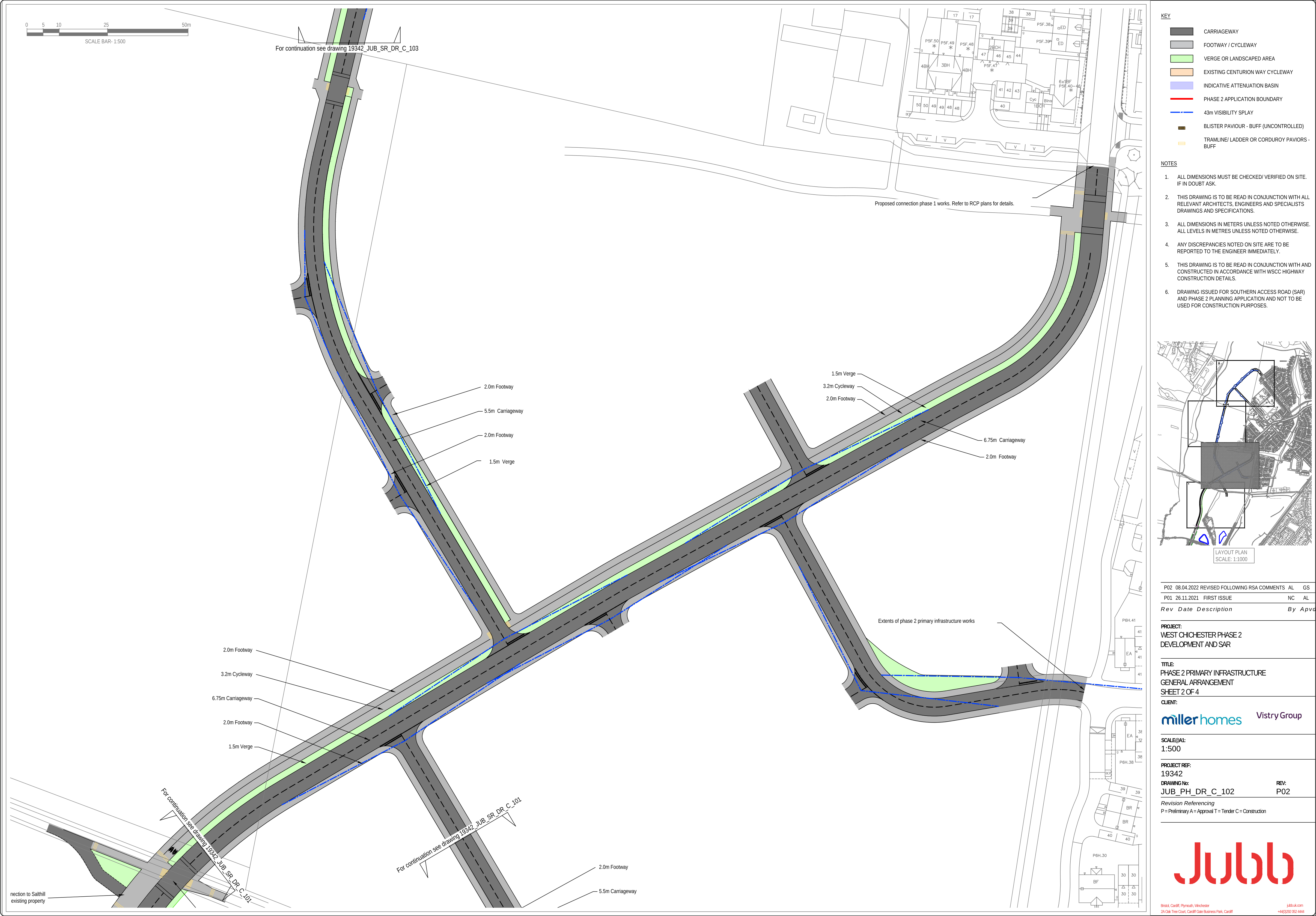
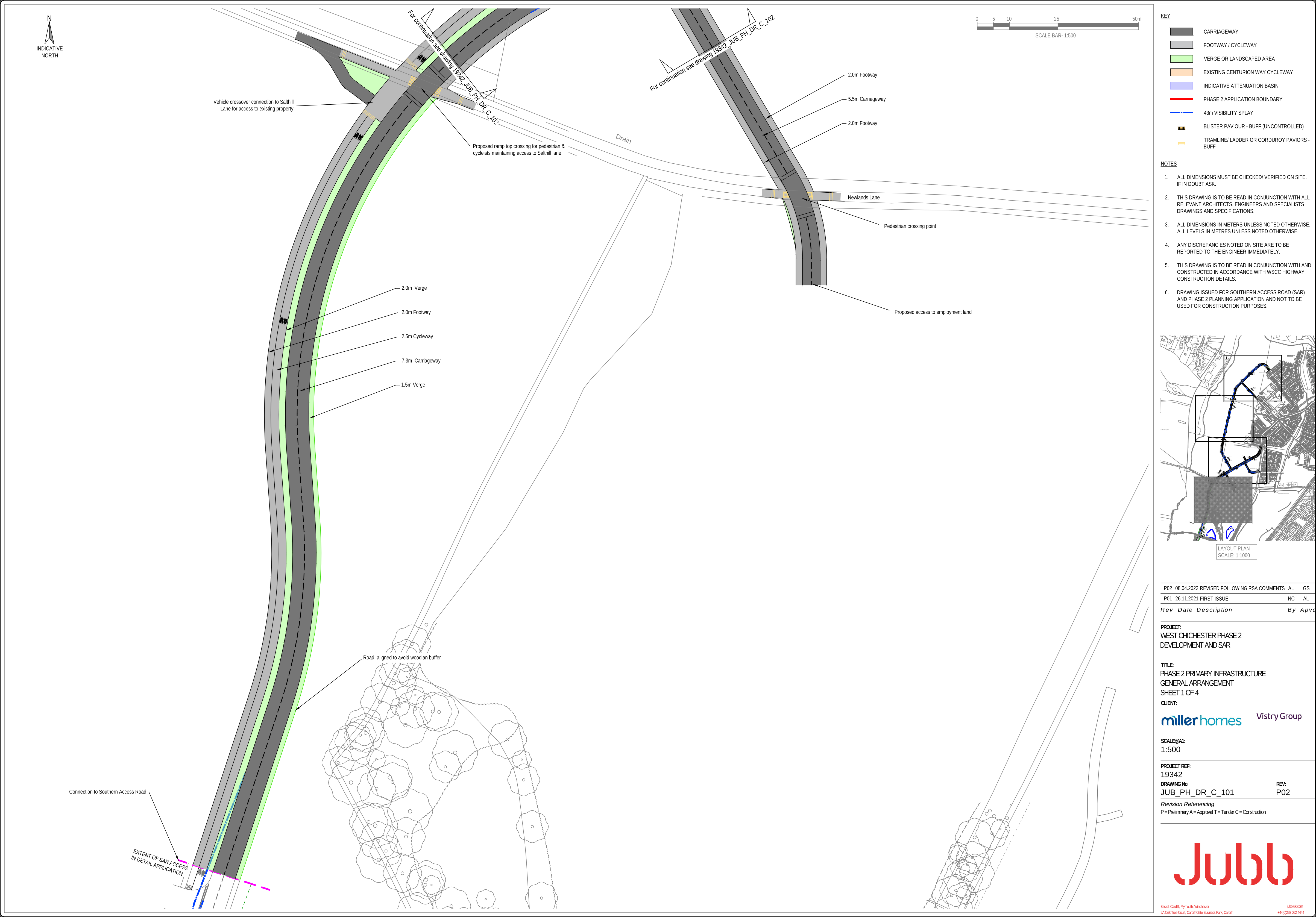
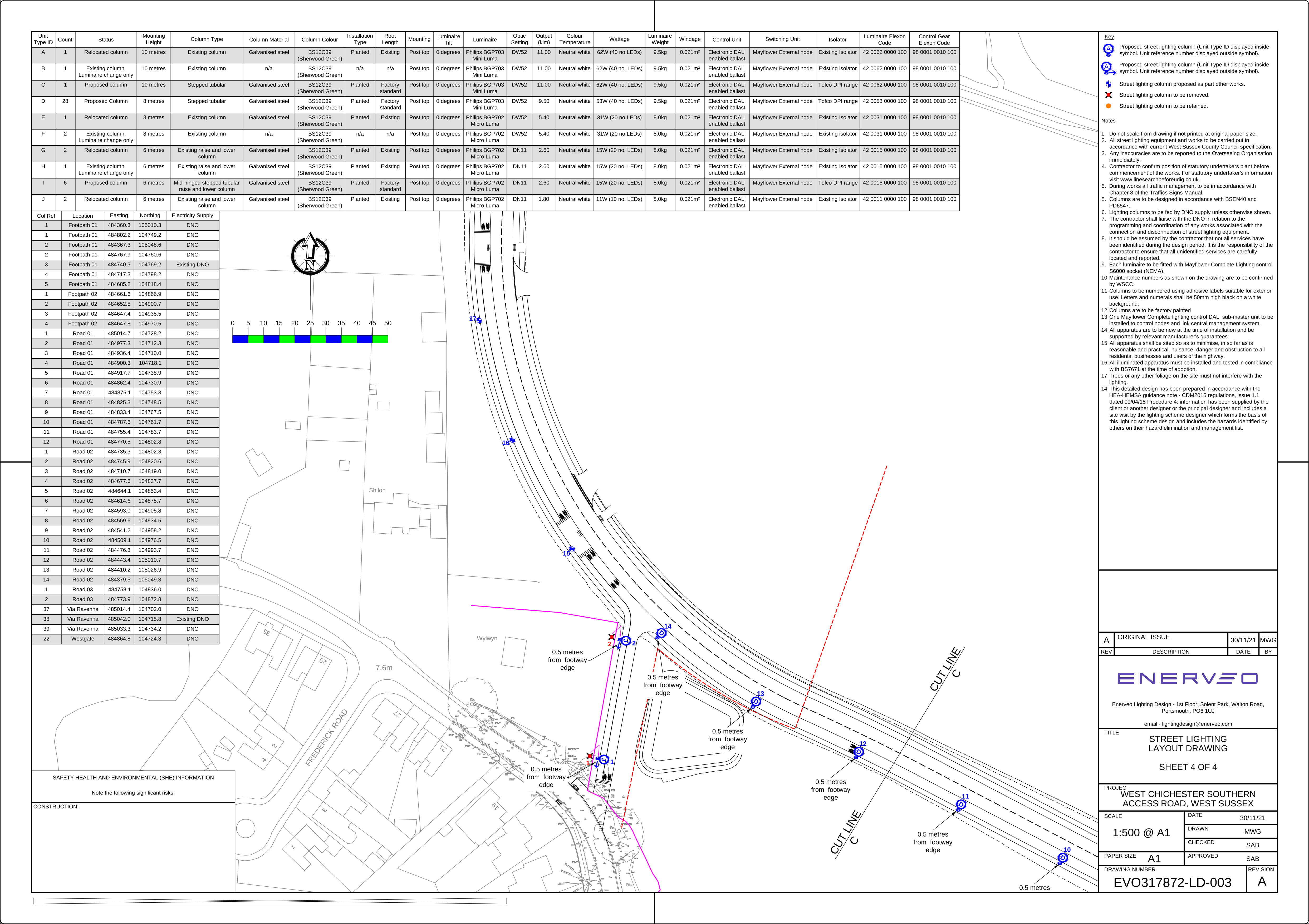
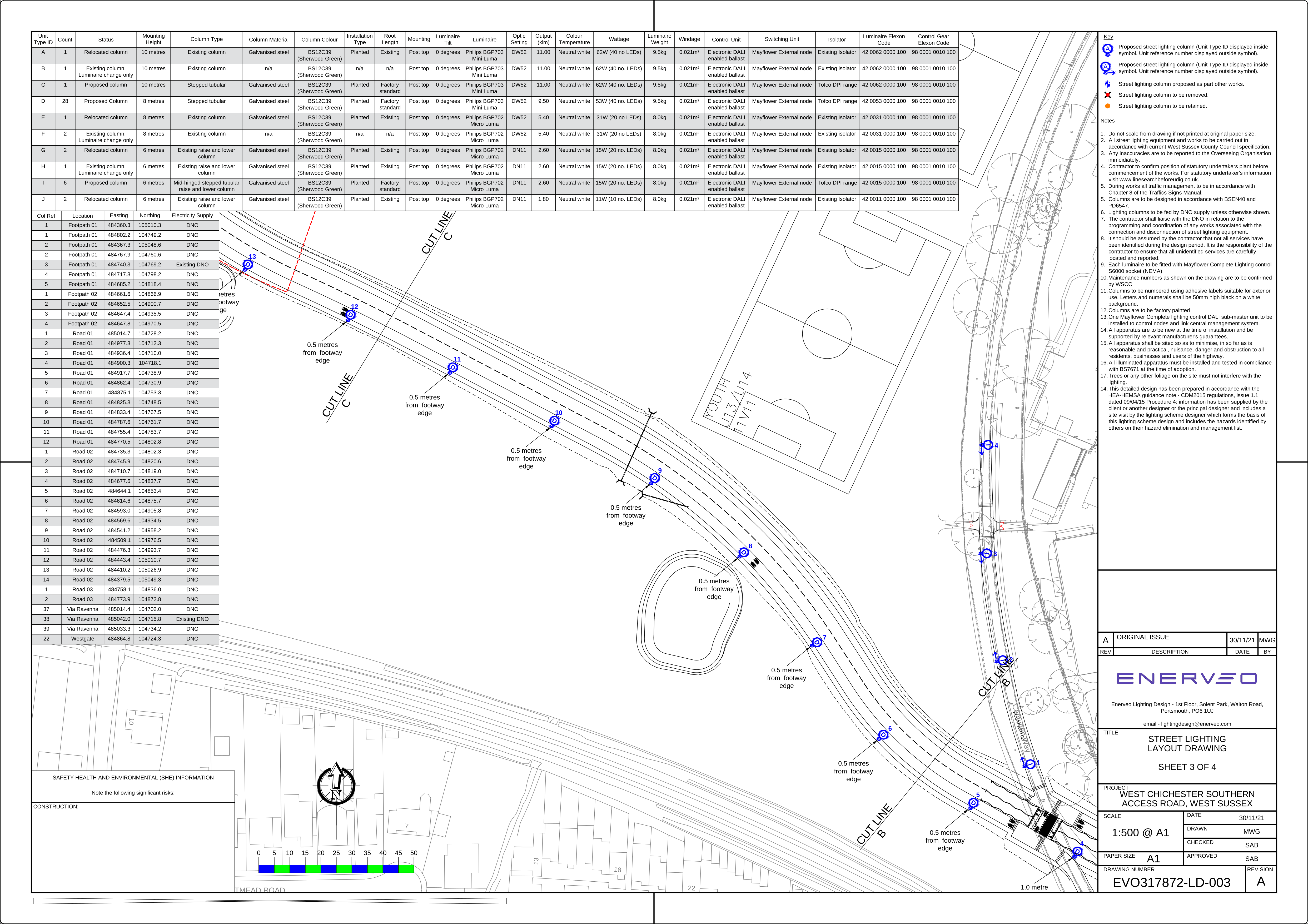
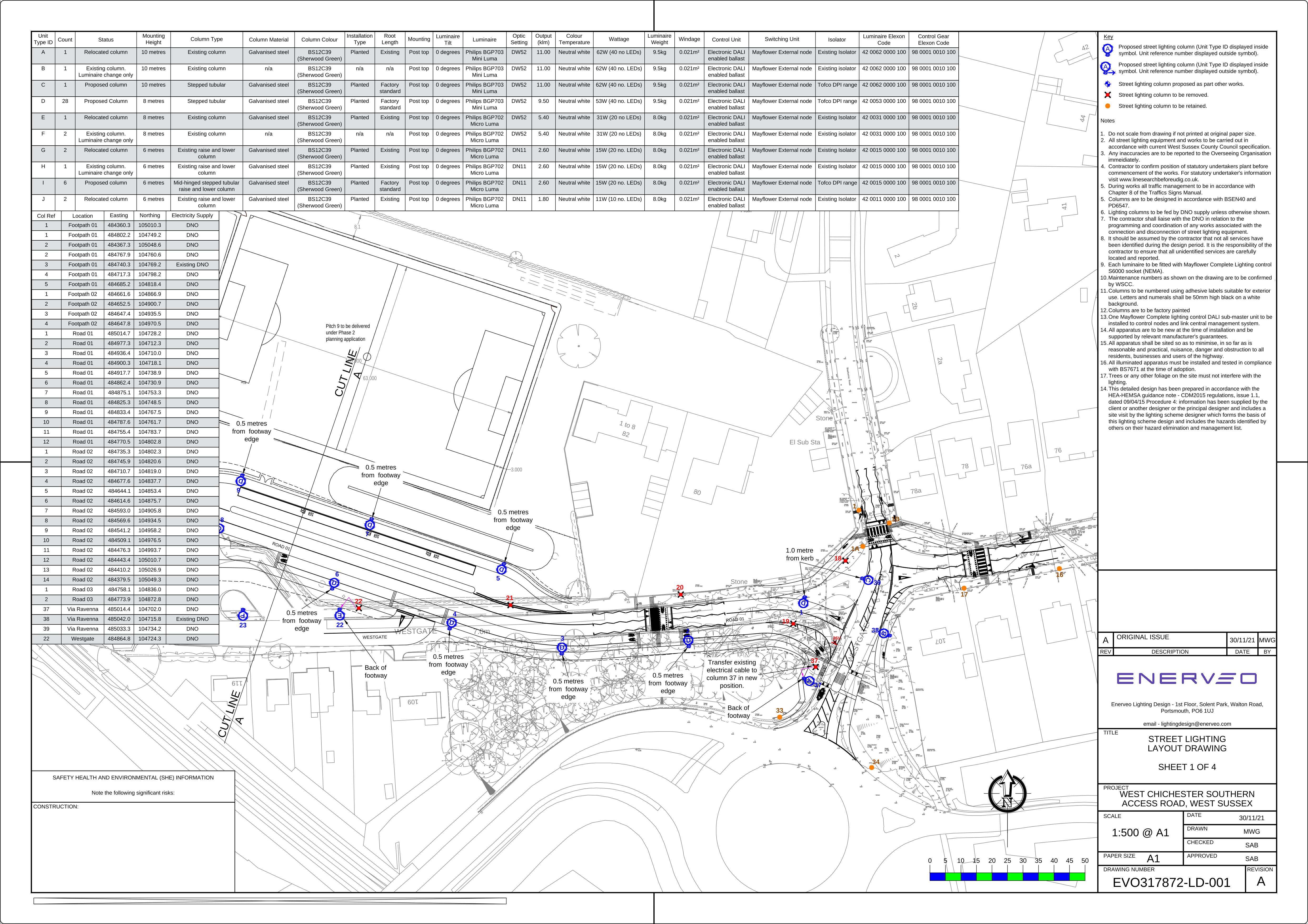
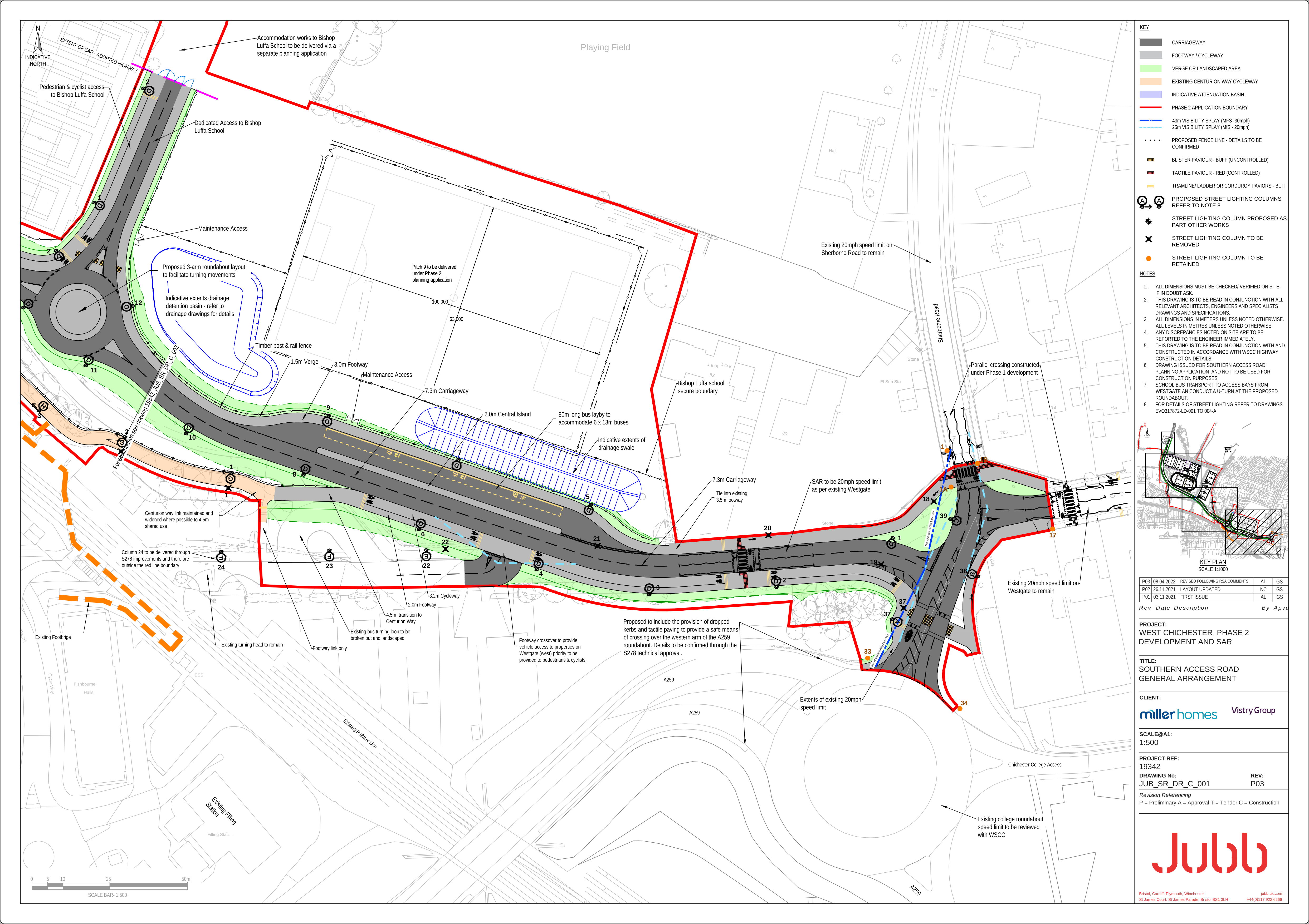
(4) If your PC has difficulty opening the PDF format plans available on the CDC website, the following images of the plans will be easier to view
The PDF plans available on CDC planning website are not optimised for convenient viewing on standard PCs.
PNG format images of some of the key plans for the Southern Access Road are available below. They are much faster to open and are of reasonable resolution.
West Chichester –Southern Access Road (SAR) Design Report
(5) WSCC Officers Previously gave the Community Assurances that the Majority of Cyclists will be Catered for Safely on the Road (Not on the Pavement) but now they have Abandoned this Commitment
WSCC officers mislead residents during Infrastructure Steering Group discussions for the First Phase of the West of Chichester Development!
In particular council officers assured both Westgate Residents Association and ChiCycle that the substandard shared pavements proposed as part of Phase 1 at the Sherborne/Westgate mini roundabout would carry only a minority of cyclists. It was frequently stated that additional measures would enable the majority of cyclists to ride safely and confidently in the roadway. This has proved to be an empty promise! No recognisable provision is provided for riding in the roadway that meets national standards for cycling LTN1/20 (or any other standard). The predicted volume of traffic will far exceed DfT recommendations for cycle routes that share space with motor traffic.
An example of the community being mislead is that ChiCycle were told the designs for shared pavement would result in a only minority of cyclists riding on the pavements at the Westgate/Sherborne-Rd. A copy of the email is available on the following link.
Sarah Quail of the Westgate Residents Association also kindly forwarded the following email to ChiCycle showing Westgate Residents had been promised that the majority of cyclists will ride in the road and that only a small number of cyclists would cycle on the narrow and busy pavements.
Sarah Quail-TRO_CHS9038_RC and Westgate,Chichester
Residents objected to the conversion of Westgate pavements permitted by TRO CHS9038. Appendix C includes the individual objections and corresponding Comments from Director of Highways & Transport.
Multiple responses within TRO CHS9038. Appendix C from the Director of Highways & Transport, promise that few cyclists will use the pavement and state that the majority of cyclists will continue to ride in the carriageway.
Director of Highways & Transport Response to TRO objection CHS9038 Appendix C No1, No2, No4, No7 & No24 states:
The majority of cyclists shall continue to cycle on the carriageway along Westgate
and additional measures are proposed to assist with this.
Councillors report that Steven Shaw (County Highways Development Team Manager) is advising the majority of cyclists will choose to ride in the carriageway at the proposed re-designed junction between Westgate and Sherborne Rd. Apparently, Steven Shaw sometimes rides a bicycle and prefers to rely on his own intuition that the majority of cyclists will feel safe enough riding in heavy traffic and will choose to ride in the road. However, there will be well in excess of 5,000 vehicles using the junction each day and the DfT advise (LTN1/20 section 7.1.4):
At flows of above 5000 vehicles per day few people will be prepared to cycle on-street
(6) Cyclists will be Directed to Leave the Road and then Immediately Ride around Blind Corners on Shared Use Pavements. In some cases Forward Visibility will be Completely Obscured by Tall Brick Walls. The Design Completely Rejects DfT National Safety Guidelines on Forward Visibility where Infrastructure is Designed for Cycling
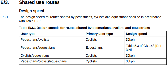
Firstly, it is important to understand how DfT safety guidelines for cyclist’s forward visibility are defined.
Geometry for forward visibility, allowing appropriate Stopping Sight Distances (SSD) are currently defined by DfT document LTN1/20 Section 5.
5.6 Cycle design speed
5.6.1 The design speed determines relevant aspects
of horizontal and vertical geometry of cycle tracks.
The design speeds in Table 5-4 should be used for cycle
only tracks and for rural shared use facilities where there
are few pedestrians – such routes should be designed
as cycle tracks which pedestrians may lawfully use
rather than a footway that can be cycled on. Cycle traffic
should preferably be separated from pedestrian and
equestrian traffic to avoid conflict and allow cyclists
to travel at a comfortable speed (see Chapter 6).
Where cycling is on-carriageway, it is assumed that
the geometry provided for motor traffic will be adequate
to cater for all types of cycle
Please note the reason why it is stated that “Table 5-4 should be used for cycle only tracks and for rural shared use facilities where there are few pedestrians” is because LTN1/20 section 5.5.3 forbids the use of shared pavements on busy residential urban streets such as Westgate and Sherborne Rd.
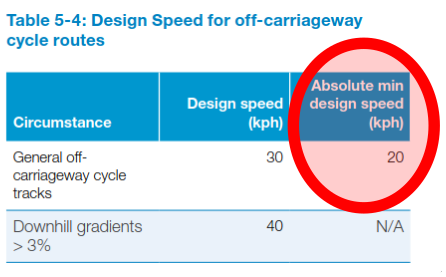
Where cycle tracks are permitted (LTN 1/20 and Gear Change guideline/document forbid converting pavements to shared use on busy urban residential/school streets) the absolute minimum design speed that defines visibility geometry is as stated in LTN1/20 table 5-4 as 20kph!
LTN1/20 section 5.7 goes on to explain minimum SSD requirements for differing cycle design speeds
5.7 Stopping sight distance
5.7.1 Stopping Sight Distance (SSD) is the distance
required for a rider to perceive, react and stop safely. It is
measured in a straight line between two points at the
centre line of the route, with the line of sight lying within
the highway or cycle track boundary. SSDs for cyclists
travelling at different speeds are given in Table 5-5.
These distances are based on the same perception
reaction times and deceleration rates for comfortable
and emergency braking as assumed in DMRB TD 9
Highway Link Design.
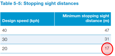
5.7.2 Designers should ensure that objects between
the carriageway surface and a height of 2.4m are
visible from an eye height in the range of 0.8m to 2.2m.
These values accommodate a range of cyclists including
recumbent users, children and adults (Figure 5.3).
5.7.3 Isolated objects with widths of less than
300mm may not have a significant effect on visibility.
This should be considered on a case-by-case basis,
taking account of the actual speeds of cycle traffic.
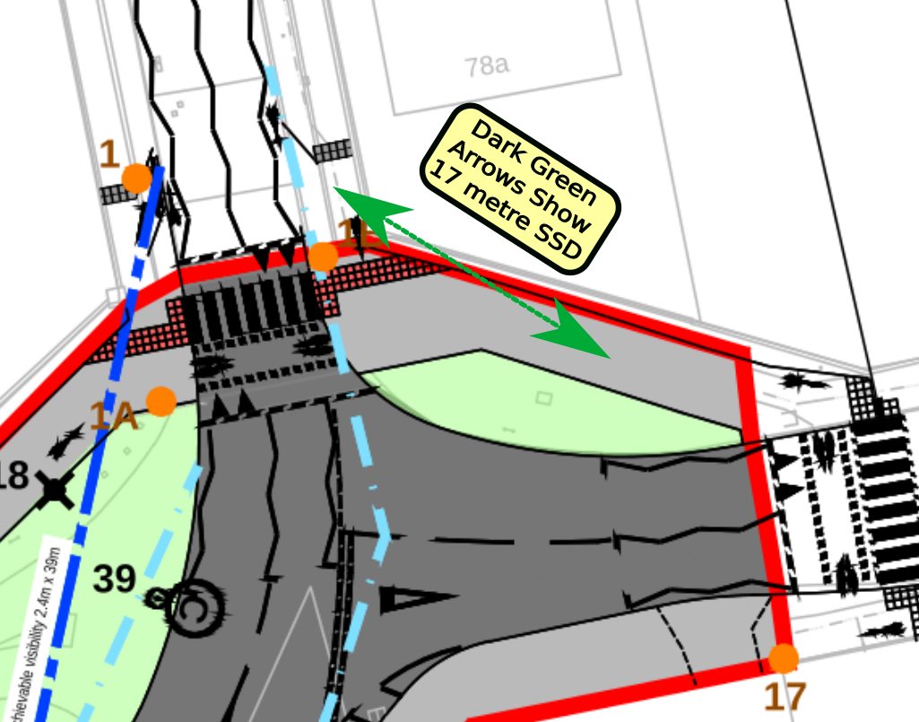
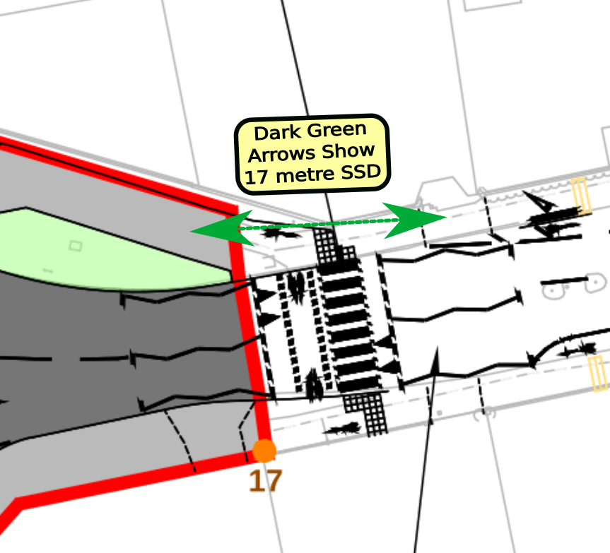
The previous text and diagrams taken from LTN1/20 show the minimum Stopping Sight Distance (SSD) considered safe for cycling on a continuing section of cycle-track (including in areas of shared use) is 17 metres! Therefore cyclists in the middle of the path/pavement should be able to see other cyclists or pedestrians on the path/pavement 17 metres ahead on continuous sections of path/pavement/cycle-track.
DfT Safety Stopping Distance visibility criteria for cyclist/pedestrian inter-visibility will clearly not be met by the shared pavement proposals outlined in planning application 22/01485/OUTEIA!
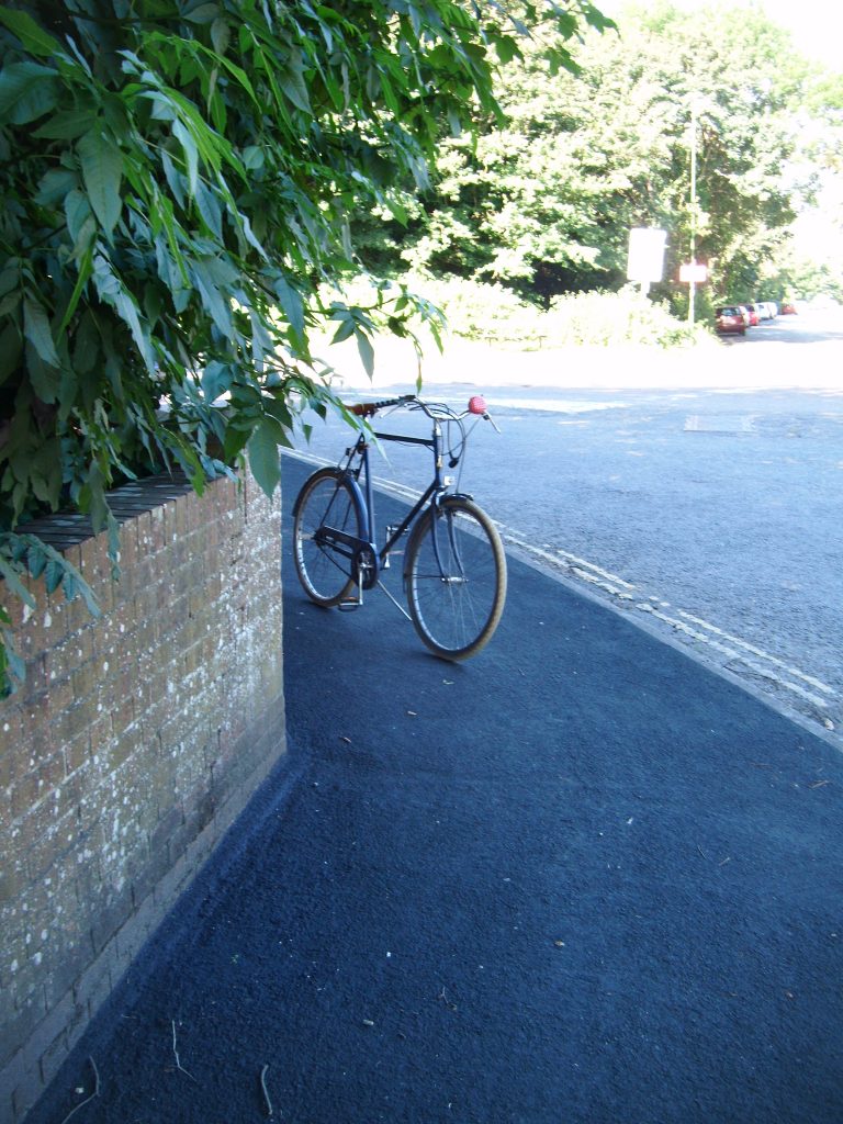
The diagram below shows the plans put forward for the shared use pavement on the Southern side of Westgate. The dark green arrows show the extent of a 17 metre SSD sight line on the corner. On the inside of the blind corner is an opaque brick wall with dense foliage hanging over it. For this arrangement to be made safe the boundary wall and hedge would have to be replaced with a wide grass verge, otherwise cyclists will be unable to have adequate visibility of the path ahead of them.
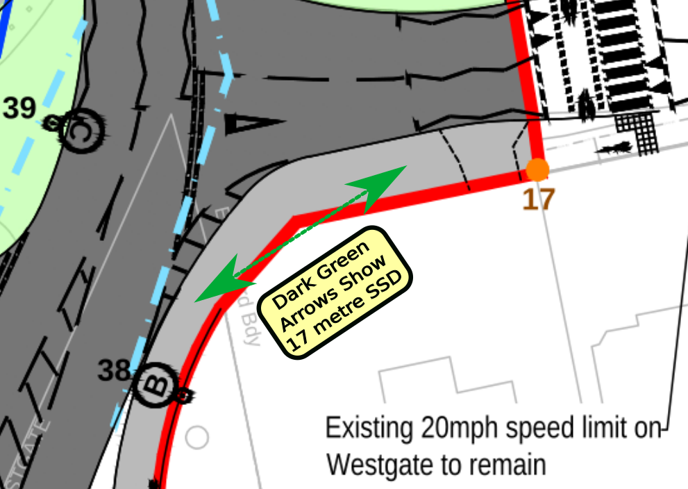
It is clearly unrealistic to expect cyclists to have adequate visibility by seeing through the wall and dense foliage illustrated by the photograph of the blind corner shown below.
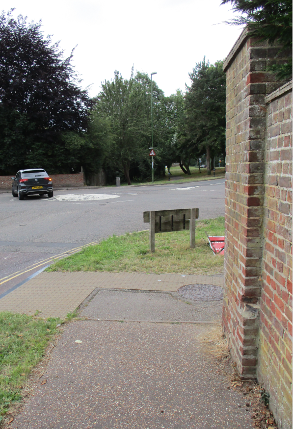
The situation on the North side of the Sherborne-Rd Westgate junction falls even further from meeting DfT safety criteria at blind corners.
Where the cycle tracks on the pavement lead northwards around the blind corners from Westgate into Sherborne-Rd there will be ludicrously little forward visibility and this will certainly cause conflict, collisions and injuries.
The following diagrams and images of the north east quadrant of the junction, illustrate how far the plans fail to meet DfT safety standards for walking and cycling infrastructure.
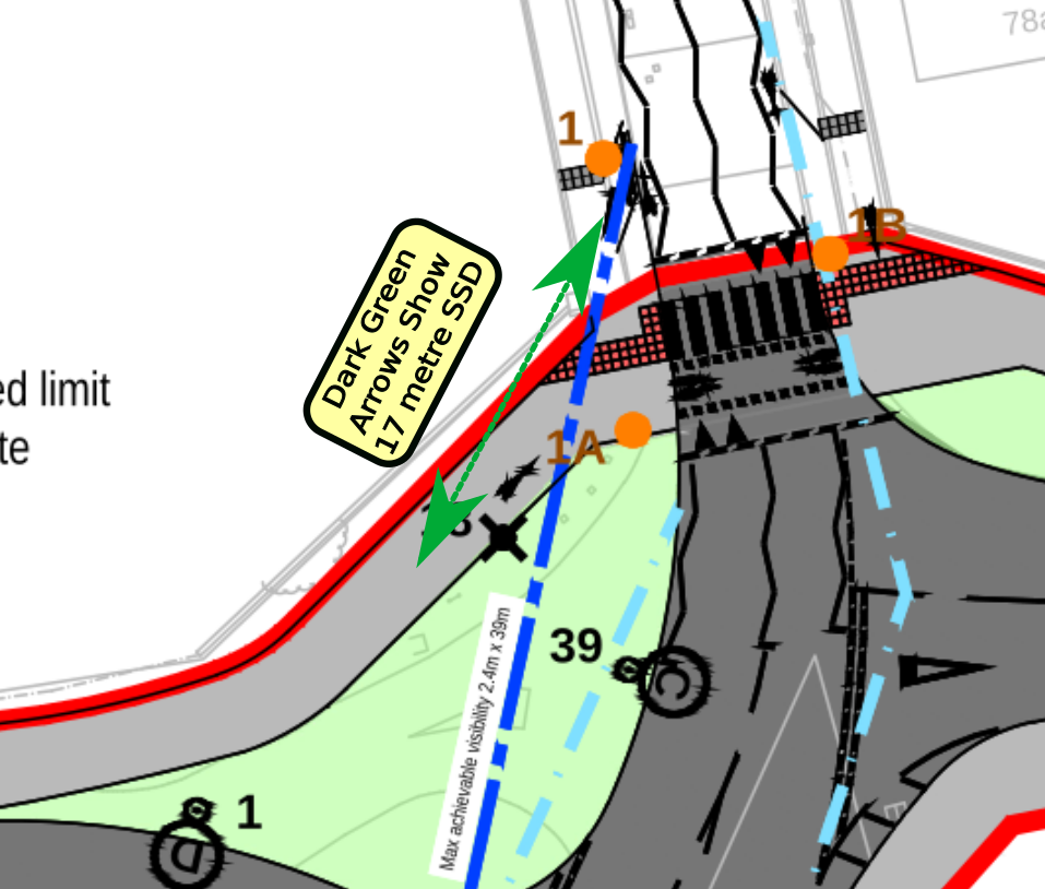
Please note that for cyclists forward visibility to extend along the 17 metre sight line shown by green arrows, it will be necessary to see through a tall brick wall!
It is ridiculous to claim there could be adequate forward visibility for a shared use pavement with the geometry of the highway boundary remaining as shown in the photo below.
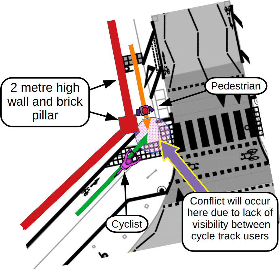
The following diagrams of the North East quadrant of the junction show further failures to abide by DfT guidelines for cycle infrastructure safety.
The following diagram shows the safety/collision danger at this blind corner
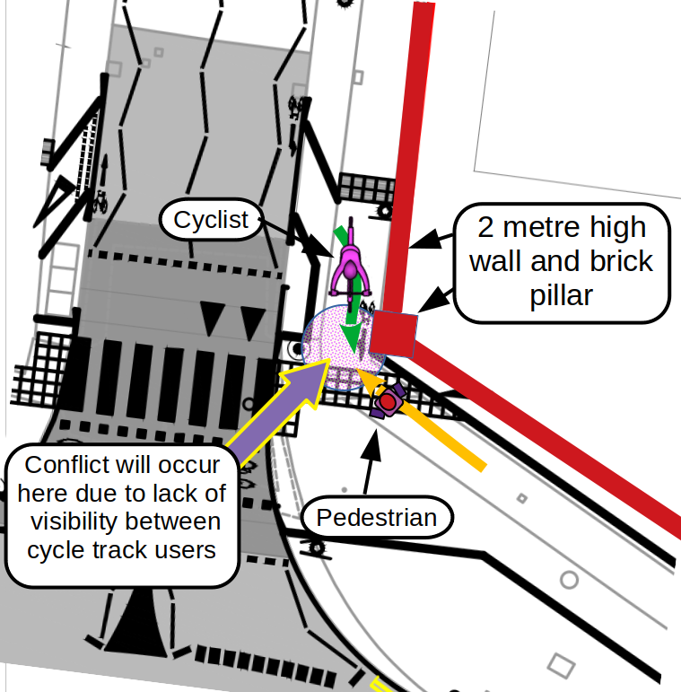
The following image shows how ridiculously short the forward visibility will be for cyclists riding around this blind corner.
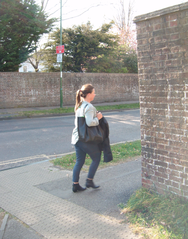
There is a further blind corner that will be encountered by cyclists riding east from the junction along Westgate.
The following diagram show inadequate forward visibility on the blind corner which is compounded by there being a blind driveway exiting immediately past the apex of the blind bend. A cyclists forward visibility is blocked here again by a tall brick wall.
(7) The Scheme Unrealistically Directs Cyclists onto Narrow Sections of Pavement that already have Extremely High Volumes of Pedestrian Traffic as School and College Student Arrive and Depart from Study
On the 25/03/2022 Carley Sitwell sent data she had collected from traffic counts made on the northern Westgate pavement.
Carley’s data shows that pedestrian flows regularly exceed the 300 people per hour maximum considered acceptable for shared use cycle-ways by DfT LTN1/20 guidelines for cycle infrastructure design (paragraph 6.5.7)
As student leave Bishop Luffa school in the afternoon, there are high flows or pedestrians, often exceeding 350 people per hour.
Over the hour period MONDAY March 21st between 2:15pm and 3:15pm Carley counted 341 pedestrians!
Over the hour period THURSDAY March 24th between 2:15pm and 3:15pm Carley counted 396 pedestrians!
It looked like Tuesday hourly figure would have also been over 300 pedestrians too had Carley continued counting for 15 or 30 minutes.
The widths and geometry LTN1/20 recommendations for shared use cycle tracks/pavement (that the current WHF plans fail to comply with) only apply where hourly pedestrian flows are less than 300 pedestrians per hour.
WSCC officers have attempted to pass off acceptance for the poor standard shared use pavement scheme by inappropriately applying CD143 standard for rural A roads and Motorways, these are only valid with hourly pedestrian footfall of less than 200 people per hour! Actual pedestrian peak hourly flows are approximately double these levels on Westgate pavements.
If even a small proportion of new residents moving into the proposed development choose to walk and cycle to commute to school or to work, then presumably the volume of pedestrians and cyclists will increase at the Sherborne-Rd/Westgate junction.
It is unrealistic to expect shared use pavements that fail even to meet minimum geometry standards for light walking and cycling traffic to cope with high volumes of commuter traffic.
The following text, tables, diagrams and images show where the shared pavement scheme fails to have adequate width for even light pedestrian and cycle traffic.
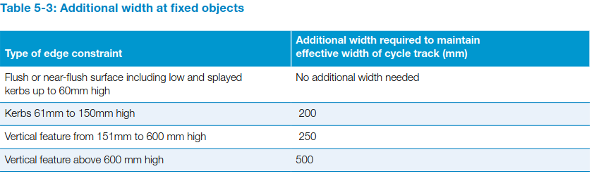
LTN1/20 section 5.5.4 explains that additional width is required where a path or cycle track is bounded by vertical features. It states:
Additional width at fixed objects
5.5.4 Where a cycle track is bounded by a vertical feature, people will not be able to use the entire width as they will naturally be wary of riding immediately next to walls and kerbs. Designers should provide additional width as shown in Table 5-3.
Table 5-3 below shows that where the proposed shared pavements at Westgate are bounded by tall walls and hedges above 600mm high, then 500mm additional actual width is required to provide the recommended effective widths for cycle lanes/paths/tracks/shared-pavements.
Where maximum pedestrian hourly traffic flows remain below 300 people per hour DfT LTN1/20 table 6-3 recommends the following minimum effective path widths:
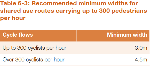
DfT LTN1/20 section 6.5.7 and 6.5.8 gives the following advice.
6.5.7 Recommended minimum widths of shared use routes carrying up to 300 pedestrians per hour are given in Table 6-3. Wherever possible, and where pedestrian flows are higher, greater widths should be used to reduce conflict.
6.5.8 Designers should be realistic about cyclists wanting to make adequate progress. The preferred approach for shared use routes is therefore to provide sufficient space so that cyclists can comfortably overtake groups of pedestrians and slower cyclists.
The geometry of the shared use pavements proposed in planning application 22/01485/OUTEIA remain the same as previous the previous poor quality proposal illustrated below.

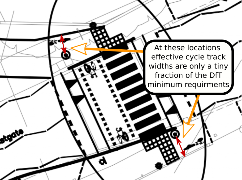
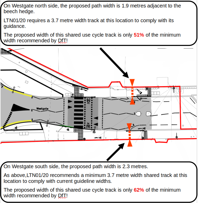
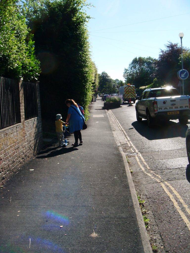
The proposed shared use pavement scheme expects commuter cyclists to ride on the narrow pavement space (shown below) between the beech hedge and the kerb, through flows of school children using the same pavement in excess of 350 people per hour! Are we really expected to accept this follows LTN1/20 guidelines asking “Designers should be realistic about cyclists wanting to make adequate progress”?
(8) National Guidelines on Cycle Infrastructure Design Forbid Conversion of Urban Pavements into Shared Use Cycle Tracks where Houses Frequently Front onto the Road
DfT guidelines on cycle infrastructure design LTN1/20 forbids conversion of urban pavements into shared use cycle tracks in areas where the are high levels of pedestrian traffic (as on Westgate where school children walk and cycle to Bishop Luffa) and it is also considered inadequate where there are frequent building frontages.
5.5.3 Where a route is also used by pedestrians,
separate facilities should be provided for pedestrian and cycle movements. However, away from the highway, and alongside busy interurban roads with few pedestrians or building frontages, shared use might be adequate (see Chapters 6 and 8). Such facilities should be designed to meet the needs of cycle traffic, however – including its width, alignment and treatment at side roads and other junctions. Conversion of existing footways to shared use should only be considered when options that reuse carriageway or other (e.g. verge)
space have been rejected as unworkable.
ChiCycle note that there has yet to be any public appraisal of alternative transport solutions for the newly proposed development (outlined in planning application 22/01485/OUTEIA) other than building a busy new road through a school street and over a quiet street currently used as a major national cycle route and then into a sensitive residential area. Conversion of the whole of Westgate into a quiet-street/school-street where motor vehicles are excluded has not yet even been discussed, let alone rejected as unworkable. The newly proposed development will be constructed adjacent to the A27 where motor vehicle access could be conveniently provided by a slip road or roundabout. Indeed, the much smaller Shopwyke-Lakes development to the east of Chichester already has two direct connections onto the A27. Perhaps routing motor vehicles away from sensitive walking and cycling routes by providing a more direct link onto the Strategic Road Network via the A27 is worth considering?
Summary principle No2 incorporated into both Gear change: a bold vision for cycling and walking (national policy for walking and cycling) and also the section 1.6 of DfT LTN1/20. Summary principle No2 makes it plainly clear that conversion of busy urban pavements in residential neighbourhoods is both unacceptable and forbidden by both national policy and DfT guidelines. LTN1/20 summary principle No2 states:
Cycles must be treated as vehicles and not as
pedestrians. On urban streets, cyclists must be
physically separated from pedestrians and
should not share space with pedestrians.
Where cycle routes cross pavements, a
physically segregated track should always
be provided. At crossings and junctions,
cyclists should not share the space used by
pedestrians but should be provided with a
separate parallel route.
Shared use routes in streets with high pedestrian or
cyclist flows should not be used. Instead, in these
sorts of spaces distinct tracks for cyclists should be
made, using sloping, pedestrian-friendly kerbs and/
or different surfacing. Shared use routes away from
streets may be appropriate in locations such as
canal towpaths, paths through housing estates,
parks and other green spaces, including in cities.
Where cycle routes use such paths in built-up areas,
you should try to separate them from pedestrians,
perhaps with levels or a kerb.
National policy and DfT guidelines do acknowledge that shares use facilities for walking and cycling can be acceptable in some circumstances. However, with all geometric advice on adequate path widths and forward visibility Safe Stopping Distances ignored, can it really be argued these plans are well-designed and implemented? LTN1/20 6.5.6 section states:
6.5.6 Shared use may be appropriate in some
situations, if well-designed and implemented.
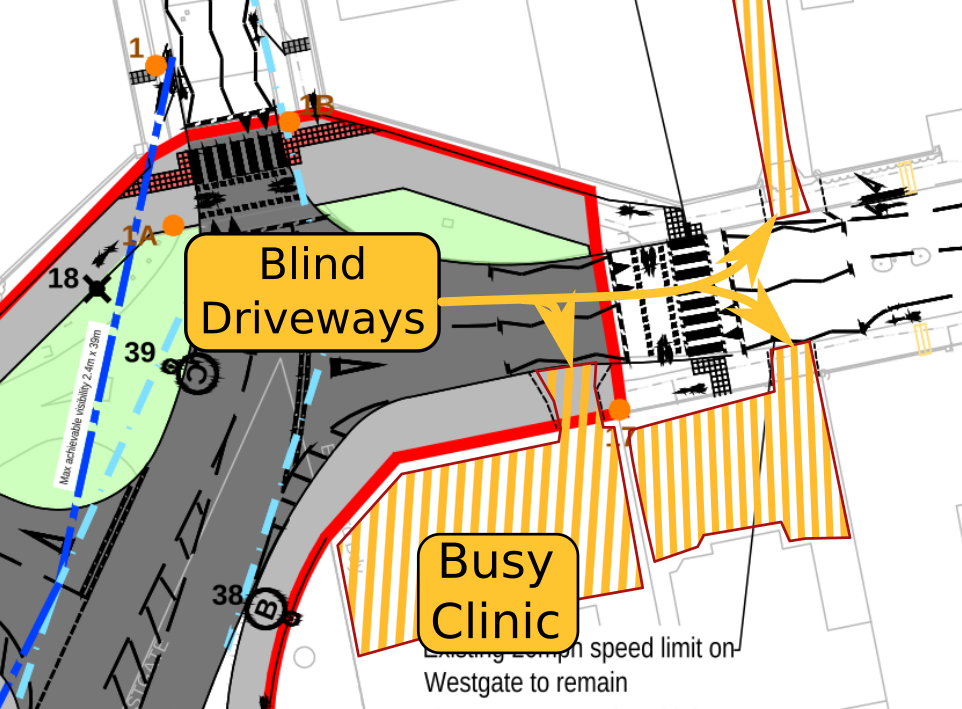
Where the scheme intends to convert Sherborne-Rd/Westgate pavements into shared use cycle tracks there are frequent properties fronting onto the road with blind driveways that will need to cross the shared cycle-track on the pavements. The following diagram illustrates where the blind driveways will exit onto the shared use cycle track. The orange hatching shows the blind driveways that cross the proposed shared use cycle tracks.
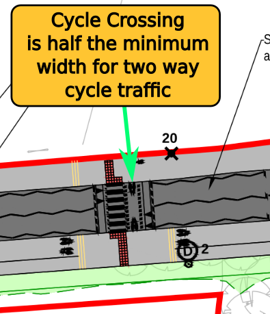
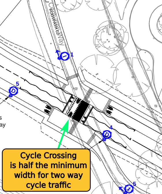
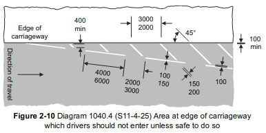
(9) Planning application 22/01485/OUTEIA Ignores DfT Traffic Signs Manual on Widths of Cycle Crossings Suitable for Two Way Cycle Traffic
The DfT Traffic Signs Manual (First published 2019) Chapter 6 states:
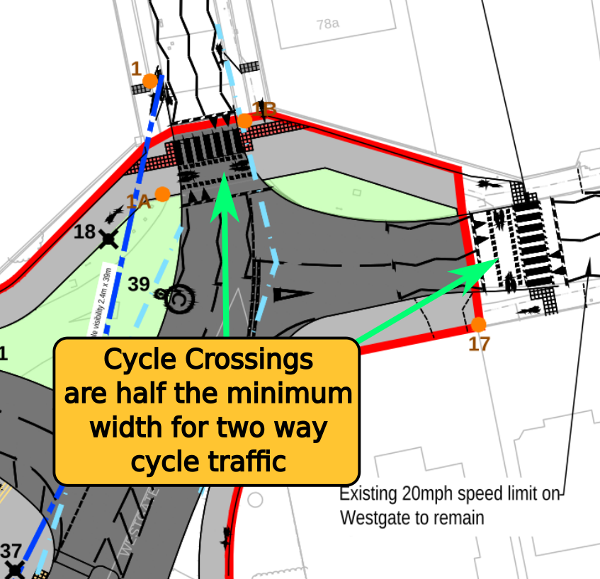
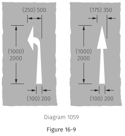
17.2.6. The minimum width of a Parallel crossing is 2.4 m for the pedestrian section, as for a Zebra crossing, and 1.5 m for the cycle route. A minimum width of 2 m is recommended for cycle lanes on busy roads, but 1.5 m may be generally acceptable for a one‑way cycle route at a Parallel crossing. Where the cycle route is two‑way the minimum width should be 3 m. The black and white stripes should be marked as for a Zebra crossing, following the advice in 16.2.8. The maximum width for the cycle route is 5 m.
All the parallel crossings in planning application 22/01485/OUTEIA will permit pedestrians and cyclists to cross the road travelling in either direction. However in every case the provision for cyclists is approximately half the minimum width for two way cycle traffic.
The following diagrams illustrate where the parallel crossings in the planning application fail to be anywhere near the DfT minimum widths:
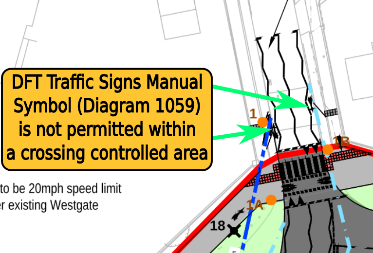
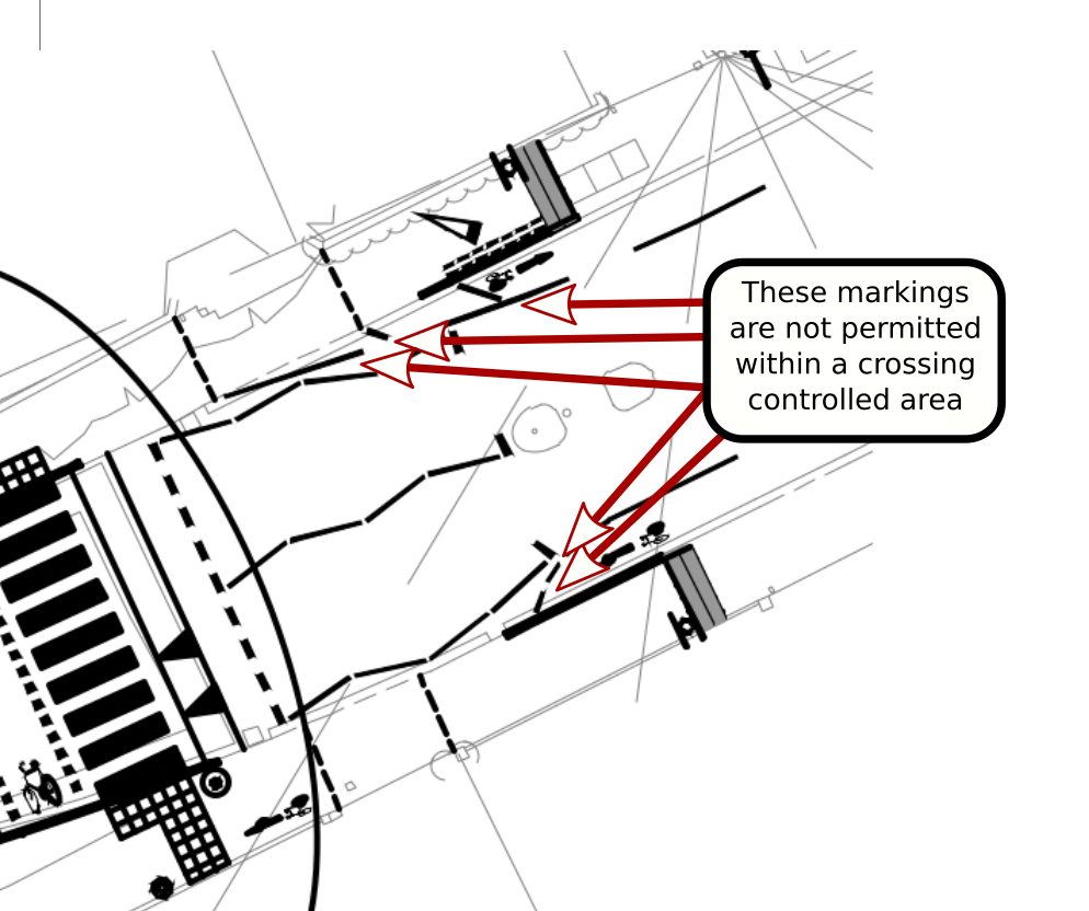
(10) Forbidden Symbols and Road Paint are use within Crossing Control Areas. This will Dangerously Confuse All Road Users at Crossings
DFT Traffic Signs Manual Chapter 6 states:
15.8.16. Markings to diagrams 1029 (S11‑4‑18) and 1062 (S11‑4‑33) may be used at or near a crossing. The use of diagram 1062 is described in Chapter 5.
15.8.17. No other marking may be used within the controlled area, except hatched and chevron markings in the circumstances described in 15.8.4 and the cycle symbol to diagram 1057 where the zig‑zags are off‑set from the kerb to allow cycling.
The following diagram symbols is not permitted for use within crossing controlled areas!
However, the following diagram shows its proposed use in a crossing controlled area (where its use is forbidden) at proposed parallel crossings in application 22/01485/OUTEIA:
Hatched, chevron or edge of carriageway markings are also not permitted between the outside carriageway kerbs and the outer zig zag lines that mark out crossing controlled areas. For example the following diagrams of markings symbols are not permitted around crossings.
However the following diagram shows their proposed use within a crossing controlled area associated with the plans to convert Westgate pavements to shared use cycle-ways.
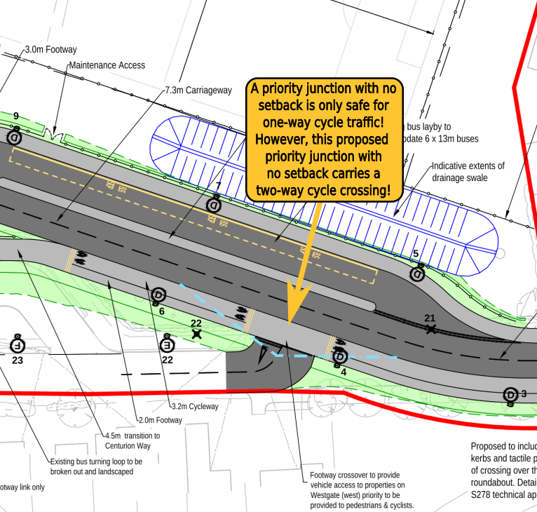
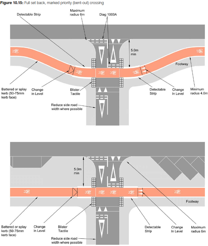
(11) Two way cycle traffic is routed across mouths of junctions contradicting safety advice given by DfT
DfT LTN1/20 section 10.5 details design of priority junctions where cycles cross side roads. Cycle-ways maintaining priority over side roads and not considered adequate of safe unless the cycle crossing is “set back” a minimum of 5 metres from the main axis kerb-line. LTN1/20 section 10.5.24 states:
Design priority, no setback 10.5.24 This approach is suitable for one way tracks travelling in the same direction as the adjacent traffic lane, as shown in figure 10.17. Drivers must give way to cyclists when leaving the side road, but there is no priority for cyclists over traffic turning in.
However, planning application 22/01485/OUTEIA shows two way cycle-traffic running flush over the mouth of a junction with no setback. This will cause unacceptable risk of collision between cyclists and motor vehicles turning into the junction.
The following diagram highlights the issue.
(12) The Cycle Route Parallel to the Development’s Access Road Fails to give Priority to Cyclists, Forcing them to Frequently Give Way to Motor Traffic Joining from the Developments Side Roads
The following diagram highlights where planning application 22/01485/OUTEIA fails to give priority to cyclists at side roads. This will make the cycle-way provided of little use for commuters as cars will stop at the give way makings blocking the progress of people cycling to work or school on a bike:
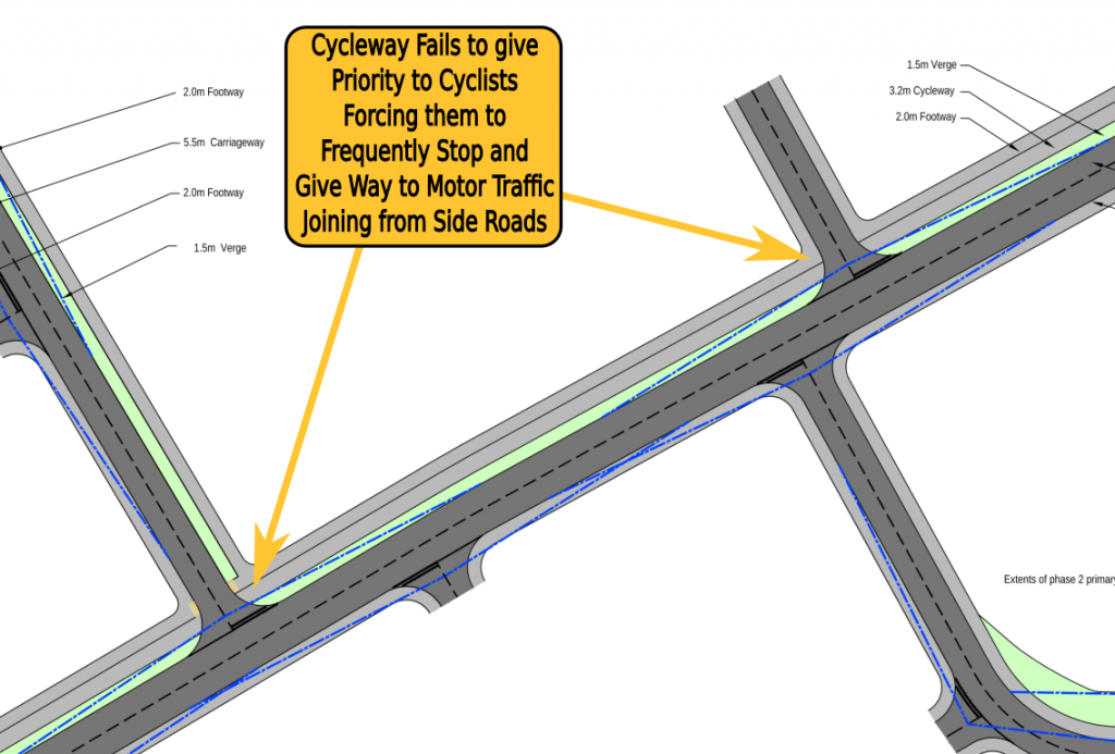
DfT LTN1/20 Figure 1.1: Core design principles, advises against making cyclists stop and give way at side roads. The following illustrative advice is given:

West Sussex cycling design guide specifies (document available from this link):
2.2.6 Along such roads, sometimes referred to as spine roads, the minimum provisions for cycle users are stepped cycle tracks (sometimes called hybrid cycle lanes, terraced or similar) on each side of the road. This also applies to smaller sites where these will ultimately form a larger overall development meeting these criteria. Table 2a sets out the minimum level of cycle infrastructure provision.
WSCC cycling design guide continues to recommend stepped cycle tracks as the minimum provision for developments with over 500 dwellings on page 12 in table 2a. This table states that:
Where spine road serves a development of greater than 500 dwellings and connects to existing highway or primary distributor road at both ends, stepped cycle
tracks are to be provided throughout on both sides of the carriageway
WSCC cycling design guide provides a diagram cross section of an appropriate stepped cycle track implementation (shown below):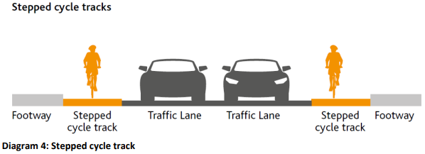
ChiCycle believe that in some circumstances, solutions other than stepped cycle tracks may be appropriate for new cycle routes parallel to housing development spine roads. However we agree with DfT LTN1/20 Cycle Design Guidelines which state in paragraph 4.2.8:
4.2.8 To make cycling an attractive alternative to driving short distances, cycle routes should be at least as direct – and preferably more direct – than those available for private motor vehicles.
Clearly, the West of Chichester proposed cycle route parallel to the spin road, is not as direct as the route available to private motor vehicles! Cyclists are expected to stop and give way each time they meet side roads branching from the spine road. This will fail to make cycling an attractive alternative to driving short distances.
(13) Planning application 22/01485/OUTEIA fails to provide adequate permeability for pedestrians and cyclists. This ignores design principles given in DfT Manual for Streets
The clipped image from document ILLUSTRATIVE_MASTERPLAN-4805316.pdf shows limited permeability for pedestrians and virtually non for people who cycle:
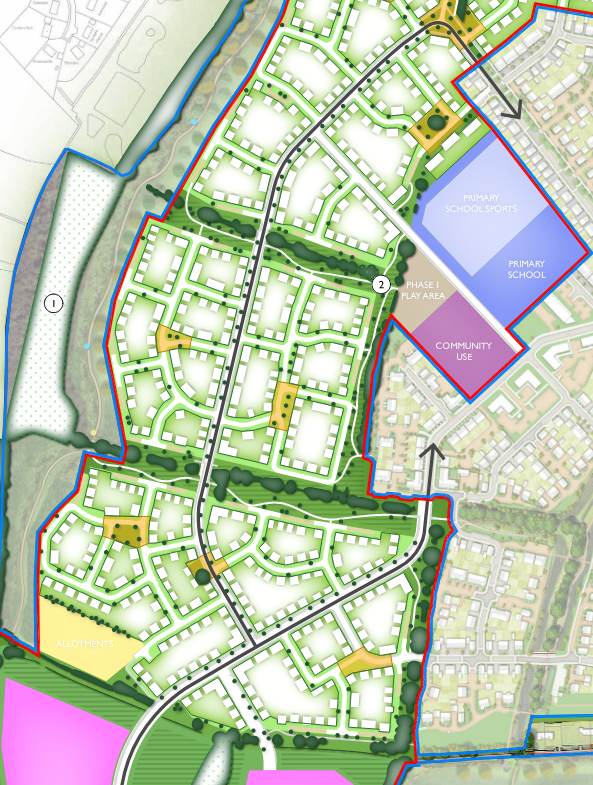
Although the green corridors are nice features of the development, they are frequently punctured by the more major roads linking the development together for motor-vehicles. It is unacceptable that sustainable transport opportunities have been sacrificed to maintain continuity of the green corridors while main routes for motor-vehicles have been prioritised and frequently breach these sensitive green strips of land.
The current national guidelines on designing and modifying residential streets are covered by the document DfT Manual for Streets. Manual for Streets (MfS) Chapter 4 “Layout and connectivity” gives advice that is able to significantly improved planning application 22/01485/OUTEIA. Section 4.2.3 highlights where the issues arise of poor permeability in the proposed development, particularly for cyclists.
4.2.3 Street networks should, in general, be connected. Connected, or ‘permeable’, networks encourage walking and cycling, and make places easier to navigate through. They also lead to a more even spread of motor traffic throughout the area and so avoid the need for distributor roads with no frontage development. Research2 shows
that there is no significant difference in collision risk attributable to more permeable street layouts.
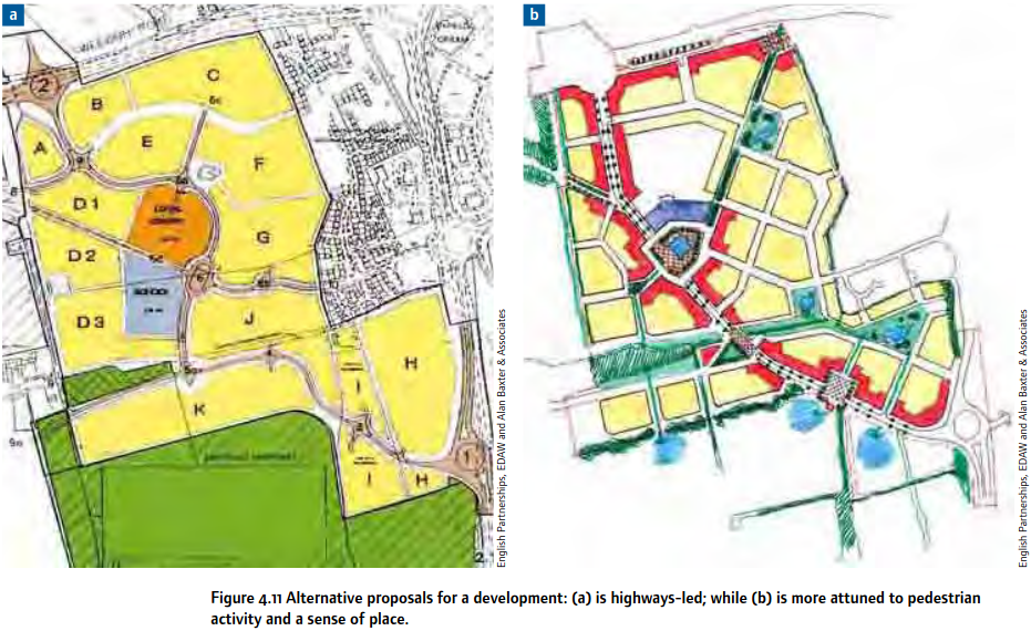
MfS Figure 4.11 (shown below) illustrates example “a” of a highway oriented development likely to lead to high levels of car dependency and alternative “b” which is more attuned to active travel, walking and cycling as practical forms of mobility and transport. ChiCycle identify that the layout master-plan of application 22/01485/OUTEIA is closer in style to the undesirable example “a” rather than example “b” which is recommended by the DfT.
In fairness to the developers, ChiCycle strongly support creation of the leisure walking routes for pedestrians through the green corridor areas and perimeter of the development. Although these routes do little to support utility walking and cycling, they are nonetheless highly desirable features that will enhance the local environment for residents. It can also be seen landscaping including planting of trees and shrubs has been thoughtfully considered.
The developers are clearly capable of high quality design as evidenced by their approach to leisure walking routes and landscaping. ChiCycle are bitterly disappointed that Chichester District Council and West Sussex Council failed to guide the developers (who appear capable) towards delivering acceptable provision for utility walking and cycling in this newly proposed development.
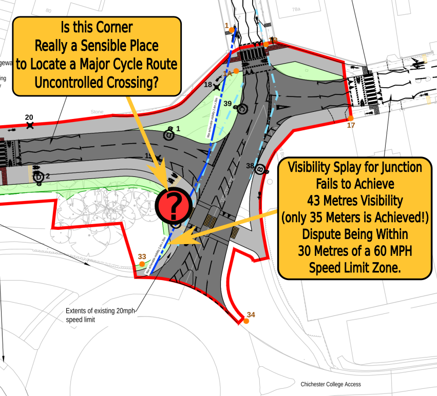
(14) The proposed uncontrolled Crossing immediately to the North of the College Roundabout has Dreadful Visibility. Developers are modelling this arm of the College Roundabout as carrying up to 14,000 Vehicles Per Day and the crossing is on the boundary of a 60 MPH speed limit. This is certainly not a desirable route for Children to cycle to school
Although planning application 22/01485/OUTEIA has introduced a crossing island, the location of the crossing is now even closer to the College Roundabout than it was previously. It is on the boundary of a transition in speed limit between 60MPH and a 20MPH zone. The western side of the crossing is only 15 metres from the roundabout with a 60 MPH speed limit. Cars will round the blind corner without seeing either the uncontrolled crossing or the 20 MPH until they are a few metres away.
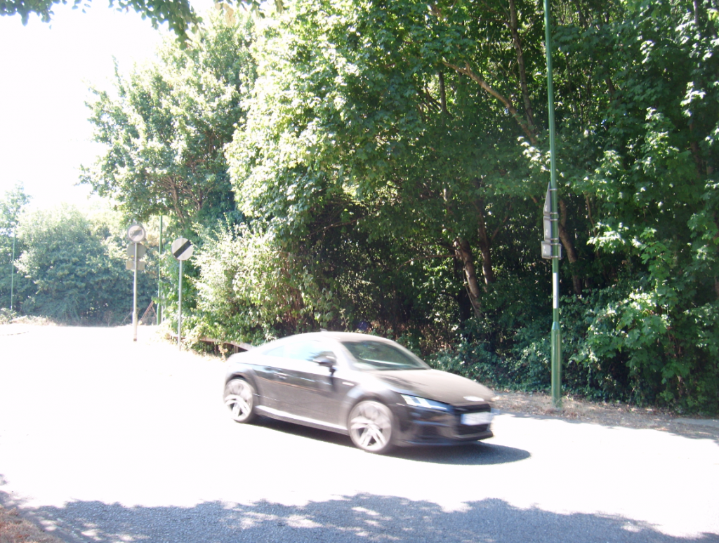
The snip taken from drawing JUB_SR_DR_C_001 rev PO3 shown above, depicts the area to the south west of the crossing as being devoid of trees. However this is a densely wooded area as shown in the following image. The uncontrolled crossing of concern will be approximately in the position of the car shown in the image:
The Visibility-splay-distances/Sight-Stopping-Distances(SSDs) used by the developers are taken from the Manual for Streets (MfS). ChiCycle very much support the design philosophies outlined in the MfS but these guidelines focus only on quiet/low-traffic residential neighbourhood streets. Can it really be argued that the MfS offers appropriate guidelines for a link section of road being modelled to carry up to 14,000 vehicles per day adjacent to the point where it joins a roundabout carrying approximately 26,000 vehicles a day?
The Manual For Streets states in its Status and application section:
MfS focuses on lightly-trafficked residential streets, but many of its key principles may be applicable to other types of street, for example high streets and lightly-trafficked lanes in rural areas. It is the responsibility of users of MfS to ensure that its application to the design of streets not specifically covered is appropriate
ChiCycle do not believe is is reasonable to apply MfS minimum visibility guidelines at this location because this is clearly not going to be a lightly-trafficked residential street.
ChiCycle members are also not reassured by the note given on the drawing stating “Existing college roundabout speed limit to be reviewed with WSCC”!
The college roundabout is incapable of passively slowing traffic without completely redesigned its geometry. It links to the A27 SRN trunk road with a short but fast length of Dual Carriageway.
(15) National Planning Policy Framework requires new developments to increase opportunities for walking and cycling by enhancing networks. However, by severing the existing walking and cycling network at the critical Westgate/Sherborne-Rd junction, the housing development scheme does the exact opposite
National Planning Policy Framework (NPPF) section 9 “Promoting sustainable transport” paragraphs 104 to 113 covers what provision for sustainable transport is required from new housing development.
NPPF paragraph 111 states:
111. Development should only be prevented or refused on highways grounds if there would be an unacceptable impact on highway safety, or the residual cumulative impacts on the road network would be severe.
As previously shown, relocating cyclists onto the pavements at Westgate is unworkable. It will result in an unacceptable safety risks as cyclists will be force to ride in the carriageway, sharing the road with unacceptably high volumes of motor-traffic, putting them at risk of death or serious injury. In addition, the current proposals will have a severe cumulative impact on Westgate residents due the the intensification in traffic through the sensitive neighbourhood. However, new housing on the Western side of Chichester does not need to be prevented or refused. What is requires is a redesign of the local transport network so that the access road does not prohibit Westgate from remaining the key corridor for walking and cycling on the Western side of the city. WSCC and CDC must make alterative, well considered town planning decisions to redesign the local transport network, before this housing development scheme can be successfully implemented.
NPPF paragraph 112 states:
112. Within this context, applications for development should:
(a) give priority first to pedestrian and cycle movements, both within the scheme and with neighbouring areas; and second – so far as possible – to facilitating access to high quality public transport, with layouts that maximise the catchment area for bus or other public transport services, and appropriate facilities that encourage public transport use;
(b) address the needs of people with disabilities and reduced mobility in relation to all modes of transport;
(c) create places that are safe, secure and attractive – which minimise the scope for conflicts between pedestrians, cyclists and vehicles, avoid unnecessary street clutter, and respond to local character and design standards;
(d) allow for the efficient delivery of goods, and access by service and emergency vehicles; and
(e) be designed to enable charging of plug-in and other ultra-low emission vehicles in safe, accessible and convenient locations.
ChiCycle are confident everything within NPPF paragraph 112 can be achieved through the local authorities taking sensible town planning decisions that avoid routeing heavy traffic onto Westgate.
(16) CDC Local Cycling Walking and Infrastructure Plan (LCWIP) prioritises the enhancement of Westgate as a key walking and cycling link through the city. If this planning application is permitted, it will no longer be feasible for Westgate to remain a practical part of the local cycle and walking network, let alone for there to be opportunities for its future enhancement
Chichester District Council has invested significant resources creating the “Chichester City Local Cycling and Walking Infrastructure Plan“. It is ChiCycles understanding that Westgate has been prioritised for investments to improve walking and cycling provision. This will be a complete waste of taxpayers money because the
(17) Access and mobility issues, particularly for visually impaired guide dog users and canine assistant dependent residents
Chichester has an ageing demographic. The 2021 census shows a 20.8% increase in people aged 65 years and over, during the last decade. Elderly people in the population require safe pavements. If frail elderly people experience collisions with bicycles directed to ride on unsuitable pavements, they are likely to fall and fracture their bones. This problem is compounded by the schemes rejection of DfT minimum standards for visibility at numerous blind corners and use of inappropriately narrow widths where the proposed plans indicate shared use pavements.
Inappropriate conversion of pavements to shared use will particularly disadvantage residents with mobility difficulties and vision impairment. There is at least one blind resident (he also suffers from impaired hearing ) who is reliant on using a guide dog for mobility. The RNIB are clear that shared use pavements are not suitable for people who use guide dogs.
There are a number of residents who rely on the use of mobility scooters. In particular, one resident who has multiple sclerosis, moved to this area specifically because she would be able to access shops independently. She also relies on a canine assistant partner, so it is essential she has enough room to use her mobility scooter while her dog walks by her side. This will clearly not be possible if pavements that are significantly below DfT minimum widths for shared use, are to carry two way cycle traffic for two national cycle routes.
(18) Safety audit highlights visibility criteria for cyclists/pedestrian visibility as it is required to do so in the DMRB
The safety audit provided for the junction at Westgate and Sherborne Rd warns of limited visibility between cyclists, motor-vehicles & pedestrians necessary for safety.
3.4.1 PROBLEM
Location: 3L (Drawing no. JUB_SR_DR_C_001 P02) – Proposed raised crossing point on Sherborne Road.
Summary: Restricted visibility could lead to vehicle to pedestrian / cyclist collisions.
The southern pedestrian / traffic inter-visibility splay is obstructed by vegetation and trees. Restricted visibility could lead to vehicle to pedestrian / cyclist collisions.
RECOMMENDATION
It is recommended that there should be no physical obstruction of the visibility splay and additionally, that the splay should be periodically maintained to retain visibility.
3.4.2 PROBLEM
Location: 3M (Drawing no. JUB_SR_DR_C_001 P02) – Proposed shared used footway /
cycle-way leading to Sherborne Road.
Summary: Restricted visibility could lead to vehicle to pedestrian / cyclist collisions.
The proposed shared use route passes a brick wall, approaching the junction with Sherborne
Road, where cyclist/pedestrian inter-visibility may be restricted. Restricted visibility could lead to cyclists to pedestrian collisions.
RECOMMENDATION
It is recommended that a buffer should be introduced between the wall and the proposed shared route to achieve inter-visibility.
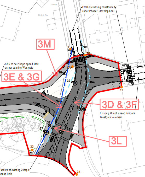
These problem locations 3M & 3L discussed in road safety audit are highlighted in the image below.
The Design Manual for Roads and Bridges outlines in document GG119 the requirements for road safety audit for highway schemes.
One of the key aspects of a stage 1 audit, is to ensure there is enough land space available for required visibility for all road users.

Stage 1, 2, & 3 of a Road Safety Audit must consider needs of cyclists (eg. adequate SSD for design speed) if the route will carry cyclists
WSCC have chosen to rely on DMRB CD143 Designing for walking, cycling and horse-riding as guidelines, for the shared use pavements on Westgate. Indeed, Director of Highways & Transport Response to TRO objection CHS9038 Appendix C relied on DMRB CD143 in several places.
DMRB CD143 states that the design speed for shared use cycle facilities shall be 30kph
The SSD corresponding to a 30kph design speed is provided in DMRB CD195 and is 31 metres!
Additional Notes
Smarter Choices – Changing the way we travel is a DfT report that studies the impact of soft measures, using evidence from the UK and abroad, to encourage modal shift away from motor vehicle dependence.
The reports summary notes that…
…those experienced in the implementation of soft factors locally usually emphasise that success depends on some or all of such supportive policies as re-allocation of road capacity and other measures to improve public transport service levels, parking control, traffic calming, pedestrianisation, cycle networks, congestion charging or other traffic restraint, other use of transport prices and fares, speed regulation, or stronger legal enforcement levels.
However, the new development has unsupportive transport policies! It will create significant reductions in provision for both cyclists and pedestrian travel. Space for the busy access road is being taken from the existing Westgate residential-quiet-street/school-street. This section of Westgate is a critical node for the local walking and cycling network. It forms a vital link for a majority of walking and cycling journeys on the western side of Chichester. In order to permit the reallocation of road-space for the proposed spine road that will carry heavy traffic, space will be taken that currently carries two national cycle ways! It is proposed at these locations that cyclists should be redirected onto inadequate shared use pavements. This is widely recognised as an unsatisfactory solution with strong evidence showing all such arrangements fail to work in busy urban environments.
ChiCycle wish to stress that soft measures such as promoting walking and cycling through Workplace travel plans, School travel plans, Personalised travel planning, Travel awareness campaigns, is only likely to succeed where there realistic opportunities for using joined up walking and cycling networks in the area! It is unrealistic to anticipate a modal shift towards walking and cycling due to West of Chichester development’s reliance on shared use pavements which the DfT advise are inadequate and unsuitable for use in urban environments.
Nonetheless, the TRANSPORT_ASSESSMENT_REV_D_PART_1_OF_4 (paragraphs 9.6.7 to 9.6.9) rely on the developers implementation of Smarter choices soft measures to reduce the predicted volume for motor vehicle traffic generated by the new development by 5%. This is extremely wishful thinking in view of the fact that construction of the Southern Access Road will causes a severe reduction in the local provision for walking and cycling.
The transport assessment reduces its base 2014 estimate of motor traffic by 7% based on the assumption of significant modal shift created by WSCC Local Transport Plan implementing Smarter Choices Measures (SCM)
10.1.13 It is noted that as part of the Local Transport Plan, WSCC has developed an integrated package of
measures and initiatives to promote behaviour changes and mode switch in favour of sustainable
transport options, thereby reducing future travel demand arising from housing and economic growth
in Chichester.
10.1.14 To reflect this, a 7% reduction was applied to the base 2014 traffic in the Vectos TA to account for the
introduction of the Smarter Choices Measures (SCM) in the City by WSCC. This approach is consistent
with the methodology adopted in the strategy modelling undertaken by Chichester District Council
(CDC) and WSCC, and was considered appropriate by the LHA for trips to/from Chichester City centre
by 2031.
10.1.15 In view of this, a similar approach has been adopted for the purposes of this study. The collated 2014
traffic information will be subsequently adjusted to account for the 7% reduction in vehicle
movements as a result of the sustainable transport initiatives and demand management measures
brought forward by the West Sussex Local Transport Plan as well as the long term impact of the
current pandemic.
3 thoughts on “Recommended Action: Write in Opposition to the New Development Access Road Plans that will Permanently Sever Chichester’s Cycle Network to the West of Chichester”