Local Authorities have Mislead our Community to Push Through a Poor Quality West of Chichester Southern Access Road!
How The Community Have Been Misled (Particularly by County Council Highways Officers)
Chichester residents have long held fears over the conversion of Westgate and Sherbourne Rd pavements to shared use cycle tracks. This issue has been of particular concern to disabled and visually impaired residents.
Current plans for the 2nd stage of the 1600 home West of Chichester development includes designs for a controversial Southern Access Spine Road. This road will bring intense heavy traffic onto formerly quiet neighbourhood/school streets in the sensitive heart of the city.
Residents were previously consulted over plans to put cyclists onto Westgate and Sherbourne Road Pavements. There was considerable opposition to the proposed conversion of Westgate and Sherborne Rd pavements to shared use! Statutory consultation over TRO CHS9038RC received 30 objections summarised in Appendix C to the report. All the objections raised related to concerns over the inappropriate conversion of sections of Westgate and Sherborne pavements into shared use cycle tracks.
Decision HT12 21/22 (allowing cyclists to ride on Sherbourne and Westgate pavements) was only granted after council officers made repeated assurances to both councillors and residents promising that the majority of cyclists would remain riding in the road and only a few less confident cyclists would use the shared use space on the narrow pavements.
Appendix C contains the following promises and assurances from the West Sussex County Council Director of Highways & Transport.
Replying to objection No1 the West Sussex County Council Director of Highways & Transport stated:
The majority of cyclists shall continue to cycle on the carriageway along Westgate
and additional measures are proposed to assist with this. The shared pedestrian
cycle route provides a safe means of access for those less confident cyclists and
this route provides a safer means of negotiating the junction.
A similar reply was given in response to objection No4 from a Resident of Westgate. In this case the West Sussex County Council Director of Highways & Transport stated:
The majority of cyclists are expected to continue to cycle on the carriageway
along Westgate and additional measures are proposed to assist with this. The
shared pedestrian cycle route provides a safe means of access for those less
confident cyclists and this route provides a safer means of negotiating the
junction.
Writing in reply to objection No7 from two Residents/business owners in Westgate, the West Sussex County Council Director of Highways & Transport again promises:
The majority of cyclists shall continue to cycle on the carriageway along Westgate
and additional measures are proposed to assist with this. The shared pedestrian
cycle route provides a safe means of access for those less confident cyclists and
this route provides a safer means of negotiating the junction.
On Wed, 7 Jul 2021, Steven Shaw the County Highways (Development Management) Team Manager wrote to ChiCycle by email making the following promise:
The majority of cyclists shall continue to cycle on the carriageway along Westgate
and additional measures are proposed to assist with this. The shared pedestrian
cycle route provides a safe means of access for those less confident cyclists and this
route provides a safer means of negotiating the junction.
Sarah Quail Chair of the Westgate Residents Association shared an email from WGRA dated 1 December 2021 illustrating WSCC made other promises that only a minority of cyclists should ride on the controversial shared pavement scheme. Indeed, WSCC had clearly promised Westgate residents there will be measures to promote cycling in the roadway.
The diagram below shows where the SAR design will cause severe conflict between pedestrians and cyclists:
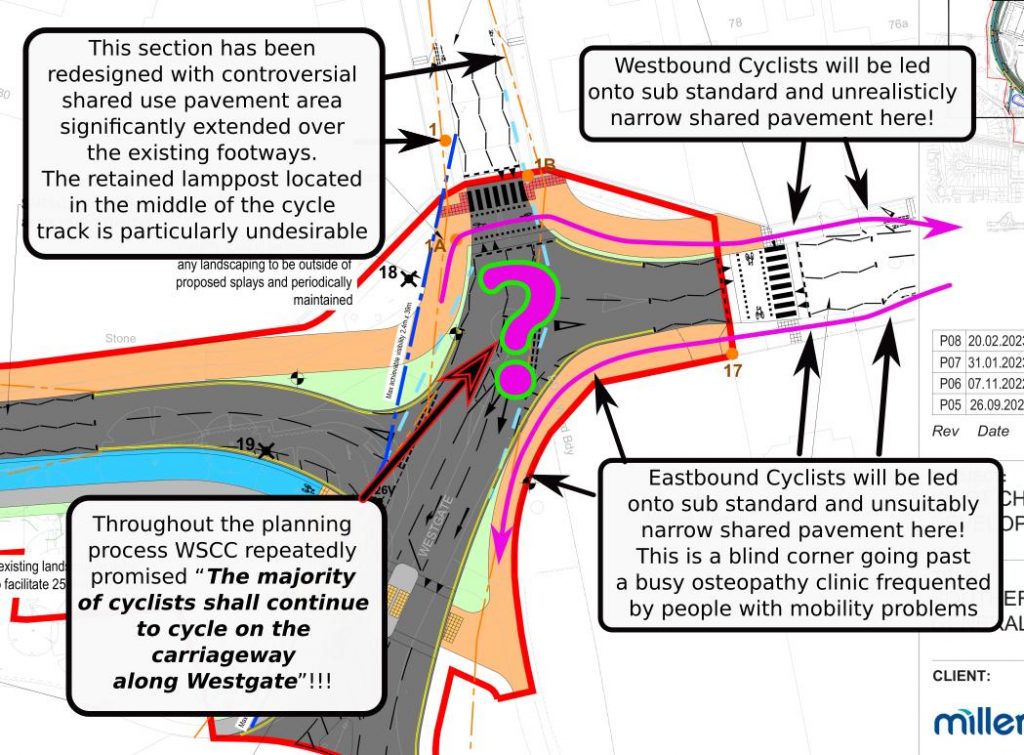
Steven Shaw the County Highways (Development Management) Team Manager acknowledged that the narrow sections of shared pavement are incapable of meeting LTN1/20 standards suitable for a busy urban school street with heavy follows of pedestrians and cyclists during rush hour. In the following quote (taken again from Appendix C) Steven’s response is so full of errors and omissions, I shall break it into sections to allow me to highlight tits most misleading elements. Stevens words follow in blue and my own comments are in red:
The available shared use width is 3.06m on the (western side) and 3.18m on the eastern side. LTN 1/20 Table 6-3 of 3.0m which the design adheres to for up to 300 cycles per hour. However, the existence of walls on the bends leaves effective widths of 2.5m at these locations. [therefore this layout fails to meet LTN1/20 minimum guidelines for urban street design. Indeed, Summary Principal No2 from LTN1/20 states “On urban streets, cyclists must be physically separated from pedestrians and should not share space with pedestrians”!]
Steven’s response continued…
CD 143 Table E/3.4 states that a minimum effective width of 3m for an unsegregated shared footway/cycleway. This can be reduced in accordance with clause E/3.5 which permits a minimum width of 2.0m where there are less than 200 users per hour. [CD143 is a National Highways standard for paths along trunk roads where few cyclists or pedestrians use a route. For a dedicated cycle route (Westgate carries two National Cycle Routes) the correct DMRB standard to follow would be CD195. Carly Sitwell conducted a survey of pedestrian traffic on Westgate during rush hour periods and discovered there is regular foot fall exceeding 300 people per hour on the northern pavement. CD143 states in clause E/3.5 “Widths of unsegregated shared use routes shall be a minimum of:1) 3.0 metres where there are 200 users an hour or more“! So in the circumstances found on Westgate pavements, CD143 requires a minimum path width for shared use of 3 metres. Steven also omits that CD143 also requires at least a half metre separation strip between the path and the carriageway. E/3.5.1 states “On segregated and unsegregated shared use routes for pedestrians and cyclists, the separation from the carriageway should be a minimum of: 1) 1.5 metres on roads with a speed limit greater than 40mph; or 2) 0.5 metres on roads with speed limits of 40mph or less“. For these reason the section of shared pavement Steven is refers to adheres to neither LTN1/20 nor CD143. This section of Steven’s response was particularly misleading to councillors and residents alike reading Appendix C
The nature of Steven’s continuing response highlights exactly why in March 2023 Active Travel England awarded West Sussex a score of Zero to reflect their consistently poor support for active travel (walking & cycling). Steven continued…
Whilst 3m or more would be ideal [3 metres is indeed the minimum width recommended for a shared use path (and its separating strip) even in the most remote/quiet rural location for DfT standards compliance!], and effective width of 2.5m still provides effective service, taking into account the constraints that exist [if this width provides effective service, then why have the DfT research experts stated a minimum width?] and. The available width in these locations ensures intervisibility between cyclists and pedestrians at the bends. [This final remark from Steven exposes his cavalier attitude towards pedestrian and cyclist road safety. To suggest a path below absolute minimum DfT width recommendation must inevitably meet all visibility criteria, simply by virtue of its generous width, is a plainly very stupid argument for a transport professional to make].
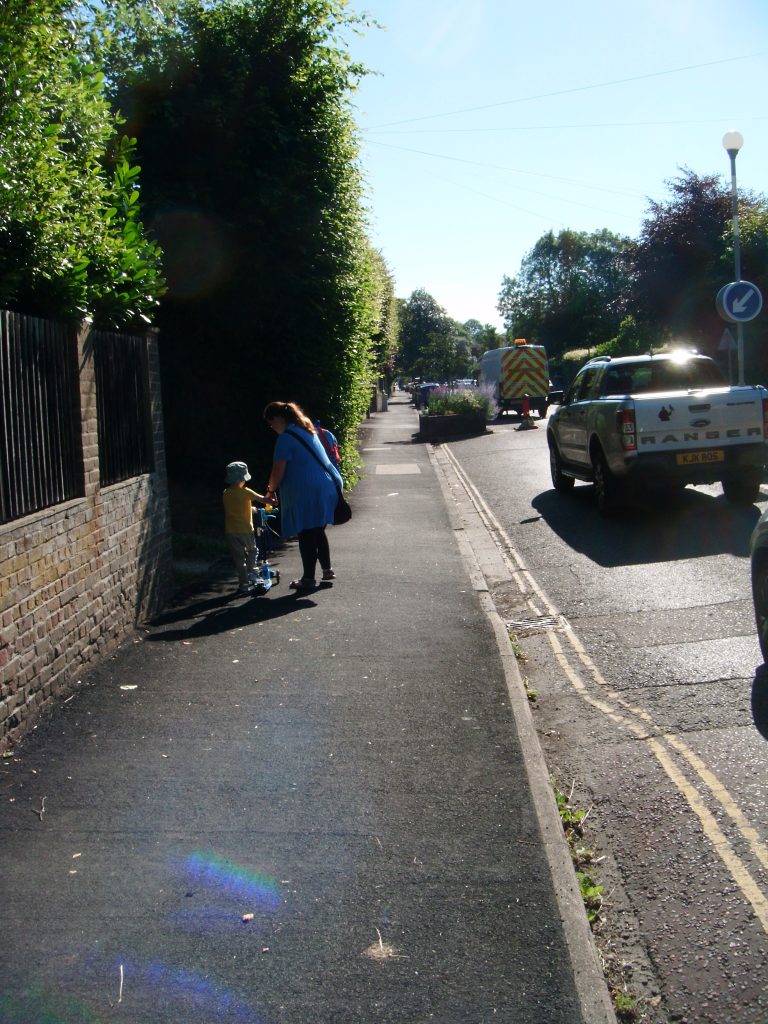
WSCC Highways Officers expect us to accept that a satisfactory two way shared use cycle track carrying significant volumes of cycle traffic can run along the pavement (illustrated below) while simultaneously carrying an additional 350 students per hour as pedestrians from Bishop Luffa school during rush hour periods. WSCC claim the section of pavement shown going past the beach hedge is capable of carrying this volume of shared use traffic.
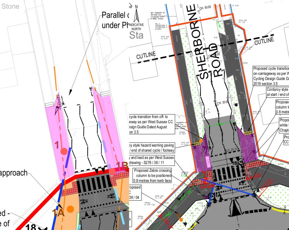
Unreasonableness of Shifting Planning Boundaries and the Undesirable Creep of Shared Use Pavements Further Northwards into Parklands.
The image half to the left (shown below) is from the latest drawings proposed by the West of Chichester development. The right half of the image is what was supposed to have been agreed by TRO CHS9038RC & decision HT12 21/22.
The boundary of the new planning application ends at the Westgate/Sherborne Rd junction (marked by a thick red line) but the new plans clearly show changes going much further North. Shared pavements are particularly undesirable in urban residential areas and it is alarming these shared use areas they are spreading Northwards dispute being outside the planning application area. Presumably residents will be unable to criticise the changes being proposed beyond the planning boundaries as they will be told this is outside of the scope of the planning decision. It therefore seems unfair that the developers are changing formerly agreed layouts of the streets beyond the boundaries of their planning application.
The purple areas shown below contrast the extent of shared pavement now proposed to push Northwards into Parklands against what was supposed to be the extent of the scheme under TRO CHS9038RC.