Critical look at Paul Wreyford’s Alternative Access Road link proposal for Planning Application 22/01485/OUTEIA
Update
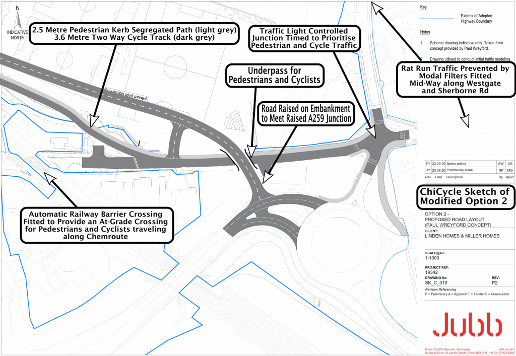
ChiCycle have reworked Jubb drawing No SK_C019 to show a modified version of Option2 (the Paul Wreyford Concept). We have some doubts about the design because it may increase congestion for motor-vehicle users but it does leave a viable/direct/convenient cycle and walking route intact along Westgate.
The motor traffic figures the developers rely on to justify their choice of Option1A, require a substantial modal shift towards walking and cycling. This is not a realistic expectation because the Option1A solution effectively severs pedestrian and cycle routes at its junction with Sherborne Rd. If a low cost compromise solution is necessary, ChiCycle’s Modified Option2 has significant advantages over Option1A because it leaves opportunities open for walking and cycling in the city.
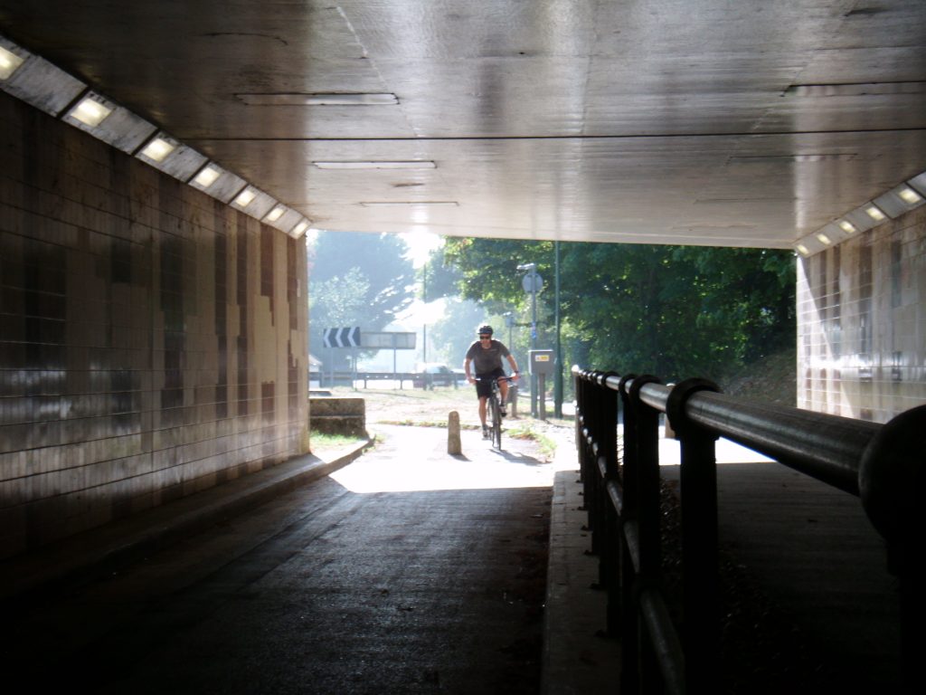
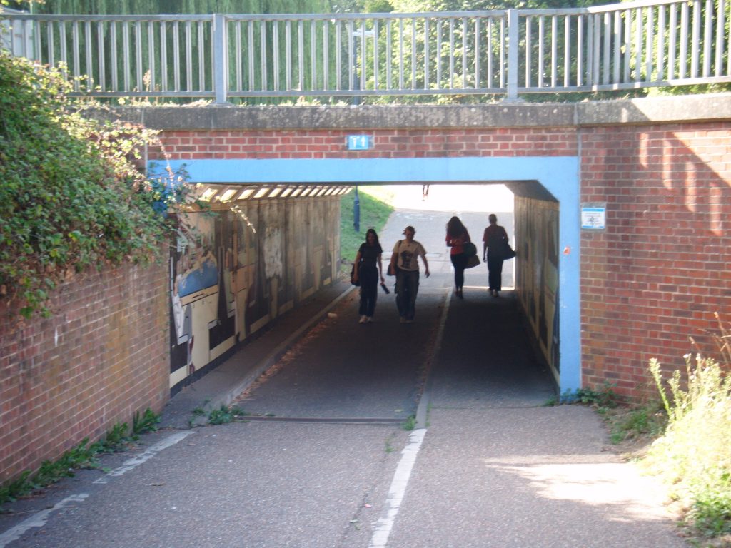
Unlike bridges over carriageways that must accommodate a double decker passing beneath, pedestrian and cycle underpasses can be relatively low needing only around 2.4 metres clearance height.
NC2 already passes beneath two underpasses on the West side of Chichester showing that the concept of using underpasses is well established and realistic. The following images illustrate the existing underpasses used by NC2 in Chichester.
Original Post
ChiCycle doubt Paul’s transport solution/option is feasible. However, from a walking and cycling perspective, it is not as bad an option as we had first imagined it to be. Unfortunately, it still links a busy access road onto/over Westgate bringing heavy traffic into close proximity with Bishop Luffa school.
Traffic Volume Data
West Sussex County Council Traffic Count Records have surprisingly little data available about traffic volumes between the Chichester College roundabout and the the A27 roundabout on the A259.
We could only find information about Southbound traffic over the railway bridge. The records we found are shown below:
CHICHESTER, A259 S. OF RAILWAY (S/B ONLY) – Southbound: Site Number: 00005708 Site Reference: A0259021L01
Vehicle Count Report Week Begin: 20 April 2009
24H(0-24) Tue13932 Wed14308 Thurs-13889 Fri-13640 Sat-13009 Sun-8510 Mon-13942 Tue-13033
In absence of any better information, ChiCycle assume there will be approximately the same traffic flow in the Northerly direction and that traffic volumes will not fall with the introduction of the new housing developments. This gives a rough estimate of 26,000 vehicles per day using the A259 road in both directions over the railway bridge (With Sunday flows of only 16,000 VPD).
Appropriate Choice of Junction
The Design Manual For Roads and Bridges give appropriate advice for planing road layouts and junctions. It gives the following graphic/chart indicating suitable junction types to suit various traffic flows in volume (CD 123 – Geometric design of at-grade priority and signal-controlled junctions):
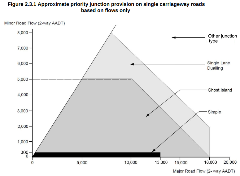
Note that the graphic above suggests the road capacity already exceeds what is suitable for “Single Lane Dualling”. Single Lane Dualling is already used on the Northbound carriageway at the Tesco Junction. To allow further discussion of Paul’s proposal, lets assume the local authorities will overlook the major road’s two way daily flow rate being 8,000 VPD in excess of the maximum recommended volume for this type of road/junction.
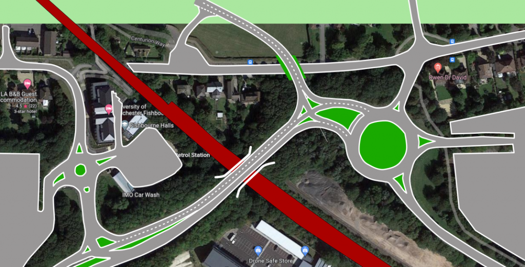
ChiCycle Indicative Sketch of Junction
ChiCycle have sketched a rough plan of what a single lane dual-carriageway junction might look like so we are able to consider its feasibility. Our sketch of this junction, at the location Paul recommends, is shown in the image below:
SSD and Splay Visibility Concerns
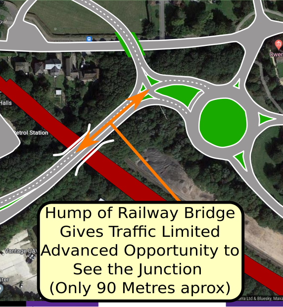
There will be insufficient visibility from the junction for people turning across the northbound carriageway with the existing 60 Mph speed limit.
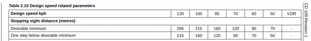
The road goes over a pronounced hump/crest as it crosses over the top of the railway bridge. Stopping sight distance (SSD) visibility criteria are given in DMRB volume (CD 109 – Highway link design). Paragraph 3.1 states:
Stopping sight distance
3.1 Stopping sight distance as identified in Table 2.10 shall be measured between driver’s eye heights of
1.05 metres and 2.00 metres to object heights of between 0.26 metres and 2.00 metres measured from
the road surface, as shown in Figure 3.1.
The relevant section of DMRB volume CD 109 Table 2.10 is shown below:
A Low Speed Limit of 30 Mph or Below would be Necessary for this Junction Layout
Design speeds are related to speed limits in DMRB volume CD 109 table 2.5 as shown below:
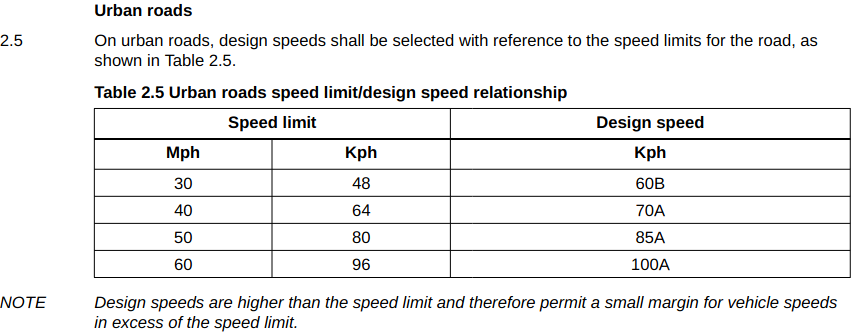
The current speed limit is 60MPH and this corresponds to a design speed of 100A. This requires a desirable minimum SSD of 215 metres (the SSDs shown are mandatory minimums for junction visibility splay y dimensions for DMRB compliance) . The distance from the crest/brow/hump of the railway bridge is currently only 130 metres so it appears the existing road layout is already significantly outside current DMRB guidelines with the existing 60Mph speed limit!
A reasonable estimate of the visibility splay distance “y” available at the type of junction Paul proposes is 90 metres. This may be permissible with a road design speed of 60kph which would correspond to a 30Mph speed limit. ChiCycle are concerned that the A259 looks to be designed for fast driving where it leaves the A27 and we fear motorists might not comply with a 30 Mph speed limit if it was applied just before the bridge. With the new access road junction only becoming visible as vehicles pass Northbound over the crest of the bridge, we anticipate motorists loosing control under hash braking just before colliding with vehicles crossing this carriageway onto the access road. However, ChiCycle have no objection to this section of road being converted to a 30Mph speed limit.
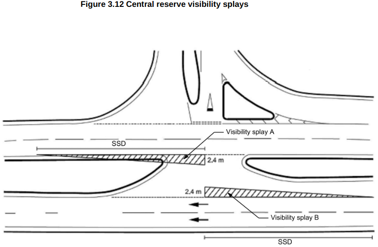
Requirements for splay visibility on a central reserve are given in DMRB volume (CD 123 – Geometric design of at-grade priority and signal-controlled junctions) and illustrated in Fig 3.12 shown below:
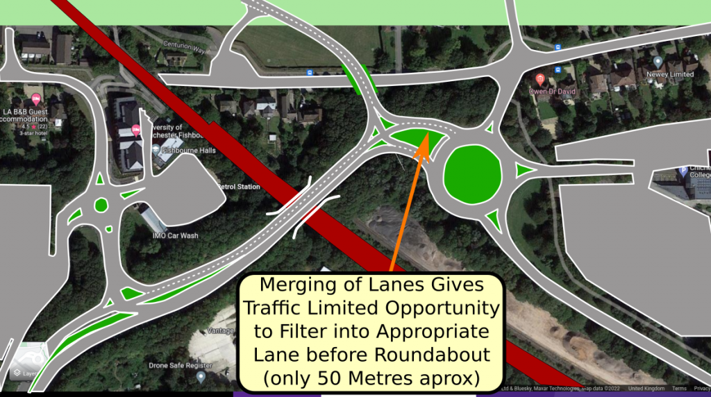
Limited Opportunities for Vehicles to Filter into an Appropriate Lane before reaching College Roundabout
An additional problem is the short distance between the junction where the new access road would join the existing carriageway and the entrance onto the College roundabout. This short length of dual-carriageway would give limited opportunity to filter into the right hand lane. However, a significant proportion of traffic leaving the access road, wishing to head South onto the A27 or to the supermarket, will wish to filter into the central lane to be ready to do a 180 degree turn at the college roundabout. This issue is illustrated in the following sketch:
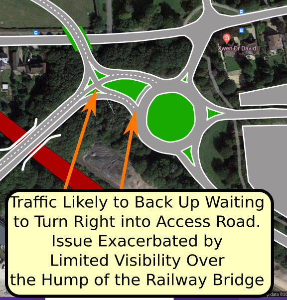
Developers Concerned Paul’s Solution Would Cause Tailbacks onto College Roundabout
The WoC developers appear to have already rejected Paul’s proposal because they fear traffic wishing to join the access road will be held up waiting to cross the Northbound A259 carriageway and therefore will cause tail backs onto the college roundabout resulting in rush hour grid lock. This issue is illustrated in the following sketch.
One of ChiCycle’s ambitions is to limit the speed and volume of traffic in the city, so we have no objection to the “traffic calming” impact that would result from this roundabout being frequently blocked because of flow issues with this proposed road layout. However, we doubt WSCC, CDC and NH will share our enthusiasm for limiting motor vehicle traffic flows either to or from the A27 into Chichester. For this reason ChiCycle believe Paul’s solution/option is highly unlikely to be adopted.
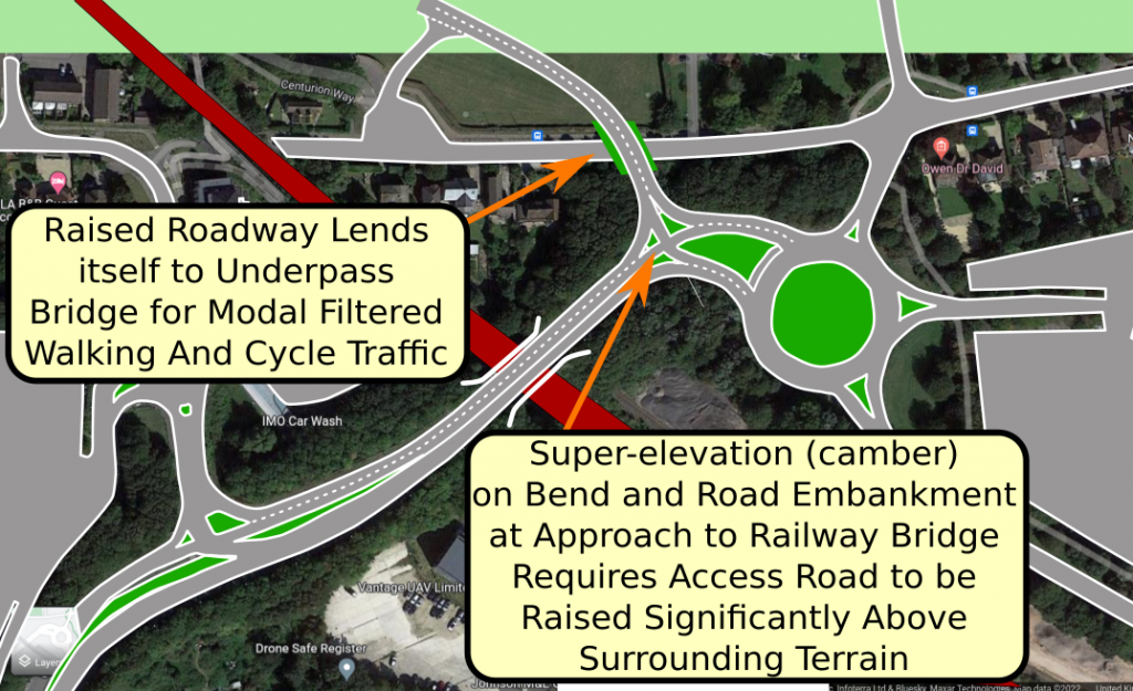
Access Road would need to be Significantly Raised but this might Conveniently Allow a Walking and Cycling Underpass on the Existing Westgate Street
A design issue with Paul’s solution/option might prove to be an advantage for walking and cycling in the city. The access road would have to be raised significantly higher than its surrounding terrain to join the A259 as it climbs its embankment to go over the railway bridge. The curved section of the road approaching the roundabout also has significant super-elevation (camber towards the inside of the curve). This requires that the access road joins the A259 with its connection either level or sloping slightly down towards the junction. DMRB volume (CD 123 – Geometric design of at-grade priority and signal-controlled junctions) gives the following advice in section 6.18.2:
6.18.2 Sections in the central reserve opening at SLD and dual carriageway junctions should fall towards,
rather than away, from the minor road.
NOTE 1 The carriageway falling towards, rather than away, from a minor road is particularly important where
there is super-elevation across the main carriageway.
NOTE 2 Where the carriageway does not fall towards the minor road at a central reserve opening, drivers can
potentially:
1) fail to see the full width of the furthest carriageway from their position on the minor road;
2) not immediately appreciate the road they are joining is a dual carriageway (particularly with SLD);
Because the access road would need to be significantly raised before joining the A259, it would be easy to incorporate an underpass bridge with appropriate modal filtering so that it only allows pedestrians and non motorised vehicles to continue along Westgate. This would retain the most direct passage for National Cycle Route No2.
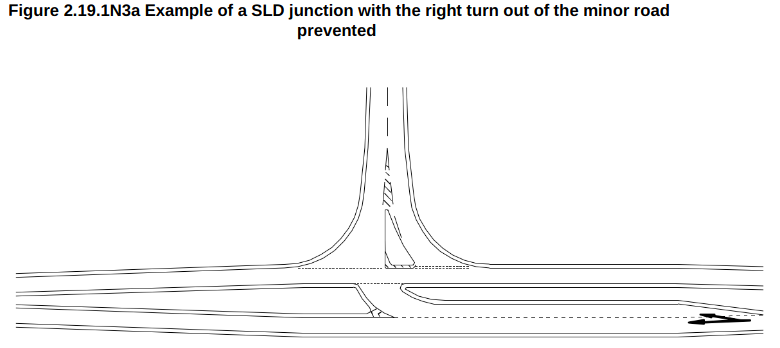
For reference, ChiCycle’s sketch/illustration of the Single Lane Dualling (SLD) junction matching Paul’s proposal, was loosely based on DMRB volume (CD 123 – Geometric design of at-grade priority and signal-controlled junctions) Figure 2.19.N3a as shown below.
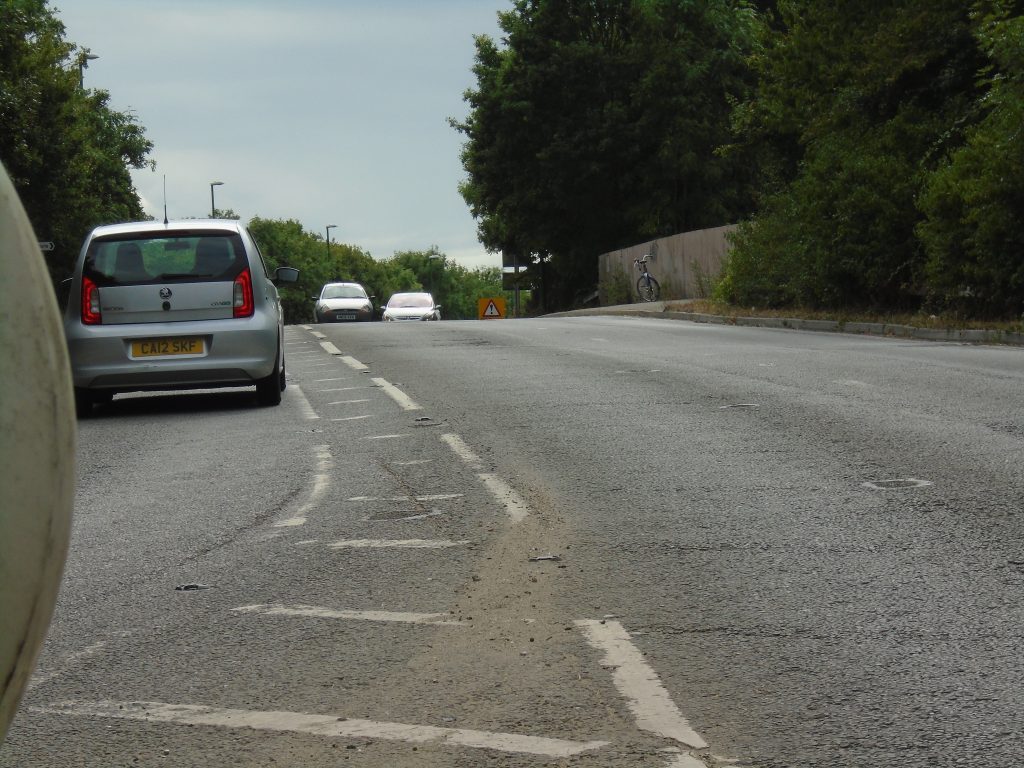
The image below was taken approximately 1.05 metres above the height of the carriageway, looking southbound, at the approximate location where the junction visibility splay would begin for vehicles turning into Paul’s proposed entrance for the access road. The approaching white Peugeot’s number plate is not visible above the crest of the road. Front number plates are usually around 0.4 meters above the carriageway. Therefore it was not possible to see an object at a height of 0.26 metres above the carriageway at this car’s location (it is outside visibility splay distance from the proposed junction). The silver Ford Ka’s number-plate is just in view as it approaches the crest of the hill. This silver car is likely just within DMRB splay visibility compliance if this road had a well enforced 30 MPH speed limit. The silver Ford Ka is approximately 90 metres from the camera, confirming ChiCycle’s previous estimates of visibility for a junction at this location.
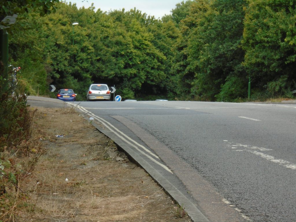
The following image was taken looking northbound from just before the crest in the A259 over the railway bridge. The camera was at approximately 1.05 metres above the height of the carriageway. The camera is around 110 metres from where Paul proposes a junction could be located. This image shows very clearly that unless extreme measures are taken such as locating the junction on a substantial embankment, there is no way that DMRB criteria could be met for 70A kph design speed (for a 40 MPH speed limit road).
Conclusion
Although a junction can fit in the available space, this would require a dramatic reduction in vehicle speed on the A259. Putting up 30 Mph signs before the bridge crest is unlikely to slow traffic enough to prevent the junction becoming an accident black spot. Perhaps road humps and a 20 Mph might do the trick. Apart from safety concerns, the A259 has heavy volumes of traffic that would make turning across the northbound carriageway difficult. This could cause people to drive past the junction heading southbound and then do a 180 degree turn around the A27 roundabout to avoid queuing. This seems likely to impact traffic flow on the A27 itself, so it is unlikely NH would accept this solution.
ChiCycle consider either of the following options are the only realistic ways to resolve the WoC development transport issues:
- The WoC development could be designed as a low traffic neighbourhood, alleviating the need for private car use altogether. Installation of a tram into the city and excellent bus, walking and cycling provision could make this a showcase for environmental responsible development.
- Alternatively, the WoC southern access road should be re-designed to connect directly onto the A27 somewhere to the west of Clay lane. If town planning was conducted thoughtfully, this would also open possibilities for reducing traffic on the A259 through Fishbourne Village centre. This could greatly enhance the local environment to the benefit of everyone living on the Western side of Chichester and also for for Fishbourne residents. It would also make the area more attractive to tourists, boosting the local economy. This follows the ChemRoute Vision initiated by Rupert Emmerson. Previously Rupert also started the Chemroute campaign for a practical cycle route between Chichester and Emsworth.
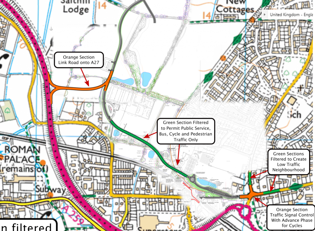
Possibilities for linking the West of Chichester more directly to the A27, allowing Westgate to become a main city corridor for walking and cycling, are shown in the following sketches:
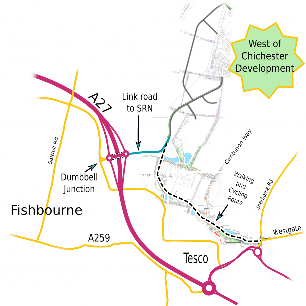
The following diagram anticipates that there will be an additional dumbbell junction to the North West of the orange slip roads shown.
Paul Wreyford’s Response
- Designed as a low traffic neighbourhood alleviating the need for private car use altogether. Installation of a tram into the city and excellent bus, walking and cycling provision could make this a showcase for environmentally responsible development.
- Alternatively, the WoC southern access road should be re-designed to connect directly onto the A27 somewhere to the west of Clay Lane. If town planning was conducted thoughtfully, this could also open possibilities for reducing traffic on the A259 through Fishbourne Village centre.
3 thoughts on “Critical look at Paul Wreyford’s Alternative Access Road link proposal for Planning Application 22/01485/OUTEIA”
I appreciate all the work you have done on this.
There is a lot of info to absorb.
With this still to be resolved why is WSCC carrying out roadworks at the bottom of Sherbourne Road now, which are likely to need changing soon when this is resolved?
My perspective is that WSCC’s key aim is to get the Southern Access Road through planning dispute this requiring substandard/unsafe provision for walking and cycling. Getting the worst substandard elements installed as supposed S106 improvements for pedestrians and cyclists, and before clearing the plans for the interlinking southern access road, is the easiest way to push through these poor quality town planning decisions.
Once the current Sherborne road alterations are in place, joining the controversial Southern Access Road traffic onto our sensitive residential streets will be a fait accompli.