ChiCycle advise that this TRO does contain some welcome changes (New Zebra Crossings) that should be encouraged; Other elements in this order might become worthwhile infrastructure with improved design (e.g. a Dutch Style Roundabout); However, we believe the creation of sub standard shared cycle tracks around the Sherborne-Rd/Westgate junction (TRO items iii & iv) should be strongly opposed for the following reasons:
Cyclists will round sharp blind corners when riding on narrow pavements directly into the path of oncoming pedestrians. Because this design element particularly discriminates against young, vulnerable, disabled and elderly pedestrians, it contravenes the Equality Act 2010.
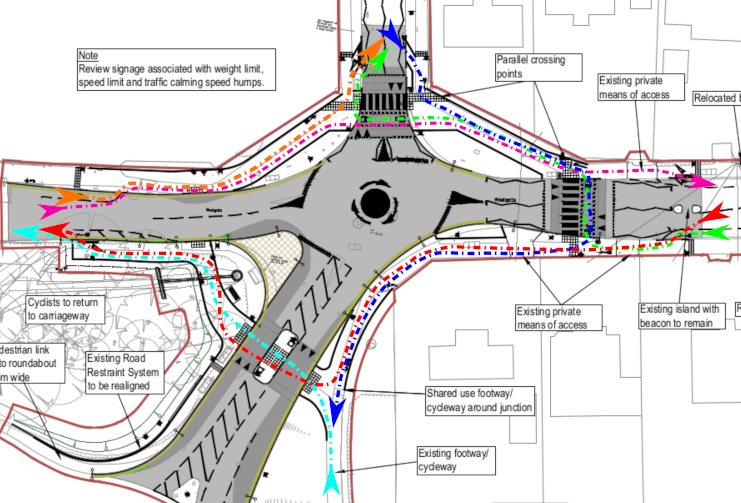
Westgate is the only viable walking and cycling route carrying pedestrians and cyclists from the city centre onto National Cycle Route No2 (South Coast Route), National Cycle Route No88 (Centurion Way) and onto Salterns Way. It is a main route used by Bishop Luffa staff and students to walk and cycle to school, for Chichester College staff and students to get into college, for parents and toddlers to access First Steps Nursery, for parents and children to reach Parklands Nursery School/Parklands Infant School, for shoppers and shop-staff to reach the Tesco Hyper market. The proposed narrow shared use pavements are not adequate to carry even existing volumes of rush hour pedestrian and cycle traffic yet this infrastructure is also intended to serve the additional sustainable transport needs of 1,600 new homes. The proposed provision for walking and cycling at Sherborne-Rd/Westgate junction must be redesigned to conform to at least minimum DfT standards for walking and cycling.
The appropriate legal procedures for conversion of pedestrian footways on existing pavements, into shared use cycle tracks, are not included or adhered to in Traffic Regulation Order CHS9038RC.
There has been inadequate consultation with disability groups over the proposed conversion of urban pedestrian footways into shared use cycle tracks.
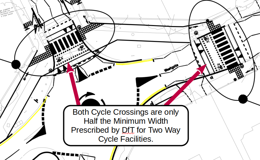
The proposed cycle crossings are only half the width required by the Department for Transport (DfT) for connection with two way cycle facilities.
Give way markings will be painted on the shared use pavements forcing cyclists to look simultaneously forward, behind themselves and also sideways as they approach each and every driveway that exits across the pavements. It is unlikely cyclists lacking confidence can successfully perform such a demanding all round observation while balancing a bike riding on narrow pavements. However, WSCC claim this infrastructure is primarily intended to meet the needs of this type of cyclist.
Parallel cycle crossings require drivers to see cyclists approaching crossings who intend to cross the road. However, in the proposed scheme, cyclists are expected to cycle along narrow shared use tracks running alongside the carriageway. As cyclists reach the crossings they may choose either to make an abrupt 90° turn into the road and over the crossings or otherwise continue along the pavement without turning. In this situation, it will be impossible for drivers to pre-empt the actions of the cyclist in proximity to the crossings and for them to safely react. Cyclists will also be expected to look both forwards at approaching motor traffic and simultaneously look back behind themselves to assess both the presence and intention of vehicles making complex manoeuvrers around a mini roundabout. This is not something a majority of cyclists can do in comfort and safety. The situation is worsened by the absence of separation strips between the shared use cycleway and the carriageway. This will leave virtually zero time between cyclists initiating a turn and transitioning onto the carriageway at the crossing.
Pavements proposed for conversion to shared use cycle tracks are significantly below minimum DfT widths for shared use.
Inappropriate road markings are proposed within parallel crossing control areas. This does not comply to standards within the DfT Traffic Signs Manual 2019.
Please object to any or all of these design failings that are certain to create unnecessary conflict between all road users if the proposed modification to Sherborne-Rd/Westgate junction go ahead.
reply to WSCC using the TRO response form on their website. Currently this link gives access but if it fails, try using this more general link covering all WSCC TROs
send in writing to: TRO Team, West Sussex County Council, The Grange, Tower Street, Chichester, PO19 1RH
Please be sure to quote reference TRO/CHS9038/RC and include your full name and address when responding as otherwise your concerns can not be taken into consideration by WSCC.
Detailed descriptions of the issues numbered above are available below the horizontal line. Please feel free to copy any of the text, links or images given below when contacting WSCC about issues within this Traffic Regulation Order.
A copy of the material in this web post is also available in the following formats
Although I have done my best to provide accurate information but cannot guarantee all my analysis is free of mistakes and errors.
Many thanks in advance to everyone supporting ChiCycle by engaging in this TRO consultation process.
Mark Record (on behalf of ChiCycle)
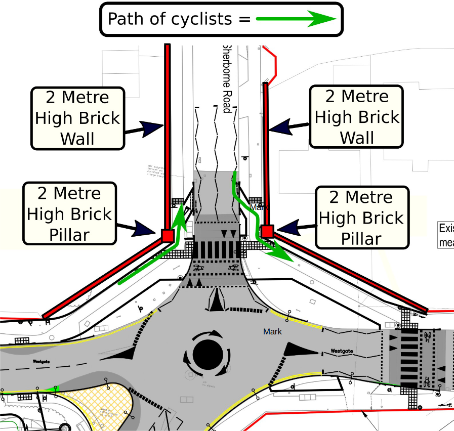
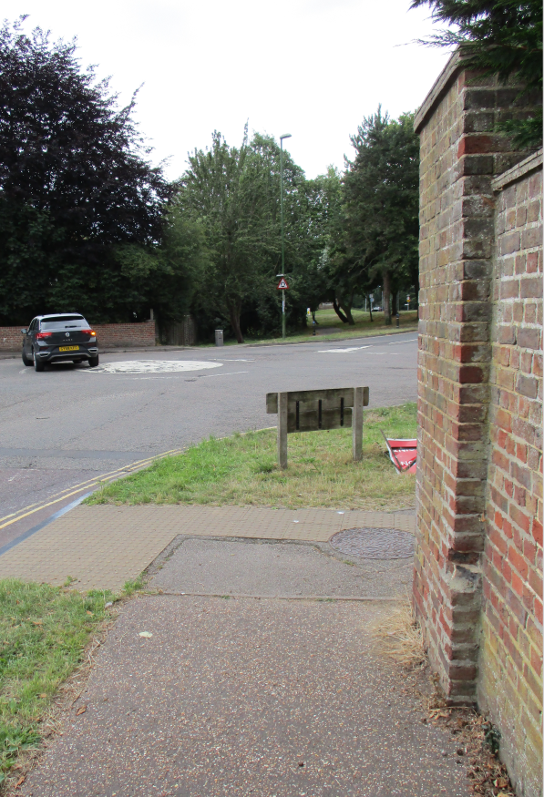
Issue No1. Cyclists will Round Sharp Blind Corners Directly into the Paths of Oncoming Pedestrians!
The Northern side of the mini-roundabout is bounded by 2-metre high brick walls. Current proposals re-locate cyclists from the road onto the pavement on a shared use cycle track. Issues are:-
1). Cyclists will round corners with virtually zero forward visibility directly into the path of oncoming pedestrians.
2). The proposed width of sections of shared cycle tracks are well below minimum widths recommended by DfT. Indeed, shared use cycle tracks are inappropriate in this location according to current guidelines.
The image above shows an annotated clip taken from the currently proposed scheme.
The route of cyclists around blind corners will clearly inconvenience/endanger pedestrians. Frail elderly members of the community are particularly vulnerable to injury from collisions with bicycles on these blind corners.
3) Conflict between cyclists and pedestrians will be inevitable on the North West pavement of this roundabout.
DfT Guidlines for Cycle Infrastructure Design LTN1/20 state:
5.9.3 “Objects such as walls, fences and trees should not be sited close to the cycle track on the inside of bends as this will potentially affect the visibility”
This guidance applies to all new cycle infrastructure (as in this case) but is clearly not adhered to in these proposals. In this example, the apex of the corner is bounded by the edge of a substantial brick pillar and wall, giving no visibility between approaching pedestrians and cyclists.
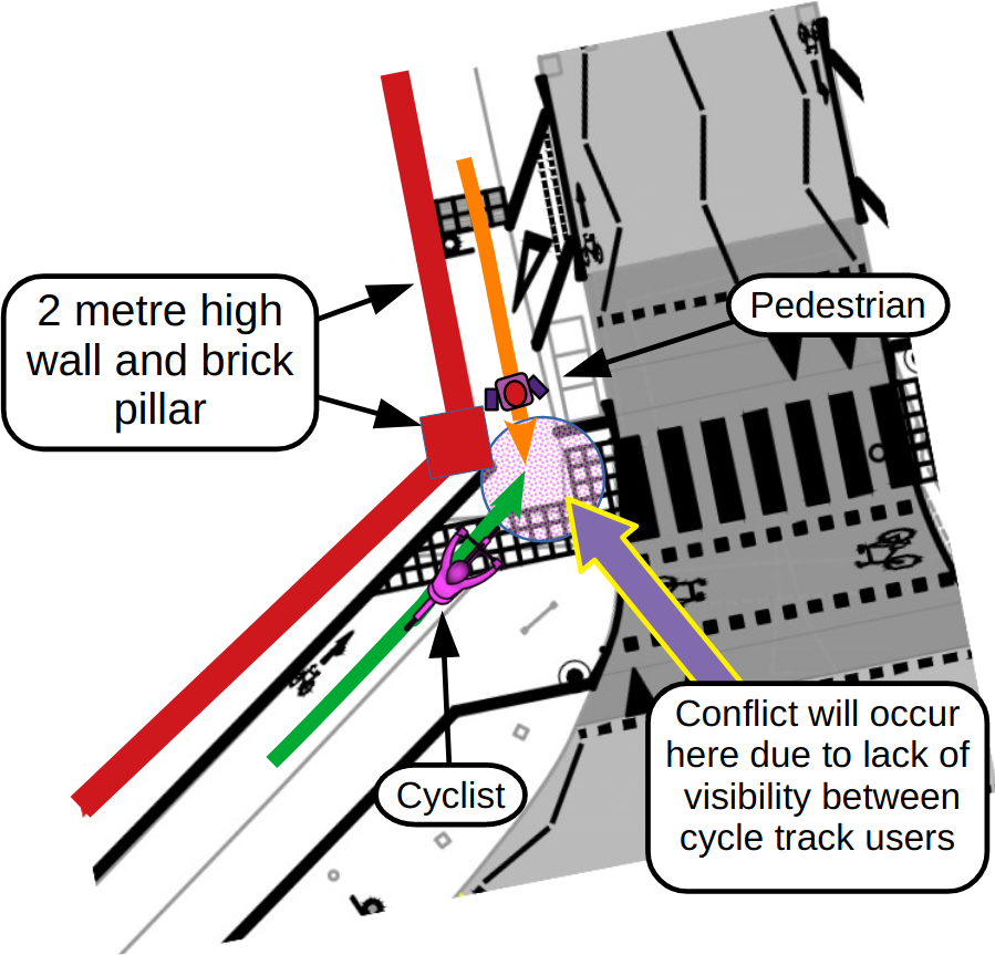
4) Conflict between cyclists and pedestrians will be inevitable on the North East pavement of this roundabout
DfT Guidlines for Cycle Infrastructure Design LTN1/20 state:
5.9.3 Table 5-7 provides minimum horizontal curve radii which should be used for cycle traffic on cycle routes including shared use facilities alongside rural highways where there are few pedestrians.
These radii are based on being able to accommodate the turning space required by the cycle design vehicle (i.e. the actual turning radius of the vehicle) and to provide adequate stopping sight distance at typical cycling speeds
The minimum inside radius given in LTN1/20 Table 5-7 is four metres but at the brick pillars this scheme uses a radius of zero metres!
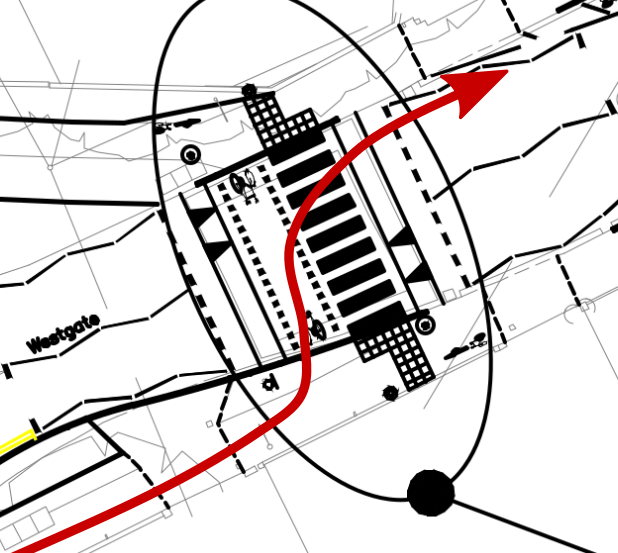
5) Conflict between cyclists and pedestrians is inevitable at this location on the North East pavement of the roundabout
The image above shows the visibility a cyclist will have when rounding the brick pillar that bounds the North East edge of the pavement. The absolute minimum stopping sight distance recommended in LTN1/20 (Table 5-5) is 17 metres! This distance is usually measured to the extreme inside radius edge of the cycle track. As cyclists approach the apex of this corner, ChiCycle approximate an actual working SSD of only 1 – 2 metres. This is between 6% and 12% of the minimum distance!
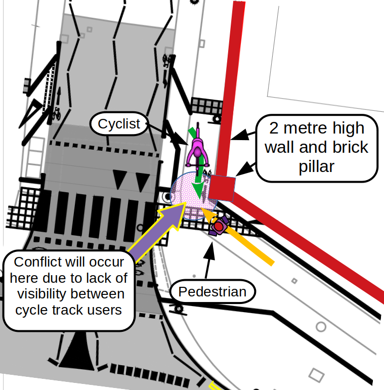
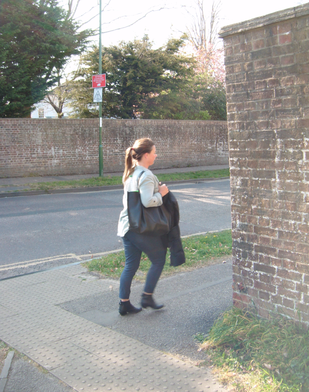
6) Conflict between cyclists and pedestrians is inevitable at this blind corner at the North West pavement of the roundabout.
The image above shows the approaching view of any pedestrian heading south on Sherborne Road, with the proposed crossing to the left. The implications are disastrous for anyone reliant on a mobility assistance dog, a frail elderly person, or a mother with children using the North West pavement. Current proposals convert this footway into a shared use cycle track!
In addition, Bishop Luffa has approximately 1,600 students who are increasingly encouraged to walk or cycle to school, rather than be driven in. The westward arm of the roundabout (West Westgate) also links two national cycleways and the Saltern’s way cycle path. Whilst the proposed pedestrian zebra crossing at Sherborne Road makes sense, is it really realistic to re-locate cycle traffic from the road onto this pavement?
7) Conflict between cyclists and pedestrians is also inevitable at this blind corner at the North East pavement of the roundabout.
The image above shows the approaching view turning north into Sherborne Road of a parent taking children to Parklands Infant and Nursery School or returning from First Steps Childcare at Chichester College.
Can it be justified for families to share space at this sharp corner with busy commuter cycle traffic approaching? Will mobility impaired and partially sighted residents feel safe using the proposed infrastructure that will have cyclists rounding this sharp corner without the protection of compliance with DfT forward visibility criteria for shared use cycle tracks?
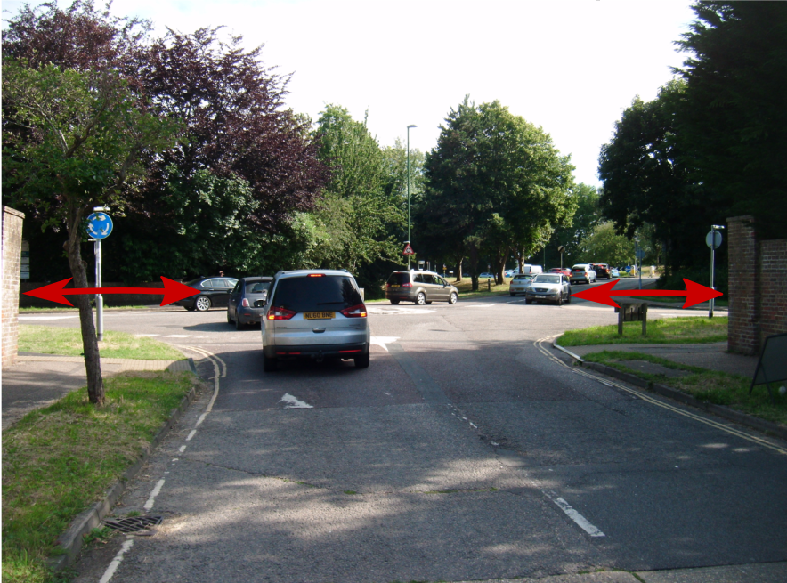
7) On the corner on the South side of Westgate, two way rush hour cycle commuter traffic will be approaching pedestrians on the pavement where visibility is severely restricted. This is unlikely to make patients of the osteopathy clinic (or any other pedestrians) feel safe using the pavement at this corner. This issue is illustrated in the following image.
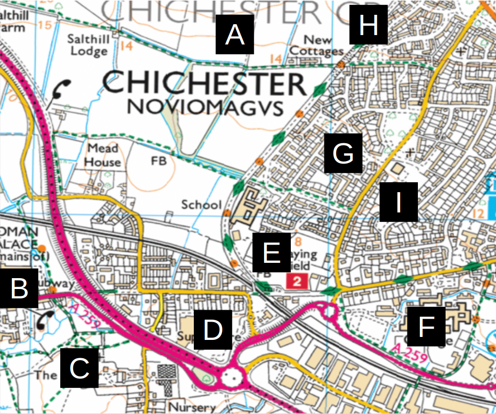
Issue No2. Westgate is the only viable walking and cycling route carrying pedestrians and cyclists from the city centre
It is unrealistic to shoehorn existing levels of walking and cycling onto existing pavements through their conversion to shared use cycle tracks!
A number of locations to the west of Chichester create substantial volumes of pedestrian and cycle traffic that could not safely use the proposed narrow sub standard shared use pavements.
A) Whitehouse farm housing development creating 1600 new homes
B) National South Coast Cycleway NC2
C) Saltern’s Way Cyclepath
D) Tesco Hypermarket (both shoppers and employees walk and cycle)
E) Bishop Luffa School with approximately 1,600 students and teachers
F) Chichester College and First Steps Nursery, 15,144 students, of whom 4,373 are full time students
G) Parklands Council Estate, approximately 2,500 residents
H) Centurion Way, counter estimates 1000 journeys made per day
I) Parklands Community Primary/Infant/Nursery School
The coloured lines in the diagram (shown below) represent paths and desire lines that cyclists are likely to follow after the proposed conversion of the footways into shared use cycle-tracks.
This design will result in conflict that will particularly disadvantage vulnerable pedestrians. Parents pushing prams or holding a child’s hand, elderly or disabled pedestrians will be unable to avoid walking on narrow shared use cycle-tracks if they need to negotiate this junction.
Issue No3. Appropriate legal procedures for conversion of pedestrian footways (on existing pavements) into shared use cycle tracks, are not included or adhered to in Traffic Regulation Order CHS9038RC.
For good reason it is illegal to ride a bicycle on a standard pavement intended for pedestrian use only. Pavements beside carriageways, intended for pedestrian use only, are legally classified as “footways”.
In order for cycling to be permitted on an existing pavement, a two step process must be followed. LTN1/20 explains on page 187″:
Converting a footway to cycle track:
To create a cycle track using part or all of an existing footway (or extending the kerbs into the carriageway) the Highway Authority must first ‘remove’ the existing footway under Section 66(4) [Highways Act 1980] and then ‘create’ the cycle track under Section 65(1) [Highways Act 1980]. The process need not involve physical construction work other than the erection of signs.
Although public consultation is not a mandatory requirement, engagement with those likely to be affected is strongly recommended, particularly groups representing disabled people.
ChiCycle can find no evidence that any groups representing disabled people (or indeed local disabled people themselves) have been consulted about the imminent legal changes to the pavements they rely on.
It is surprising that Traffic Regulation Order CHS9038RC includes reference to HIGHWAYS ACT 1980 – SECTION 90 (A), (C) & (D) which covers the construction of road humps by highway authorities but fails to consult on the controversial conversion of the pavements into cycle tracks.
ChiCycle feel it is unreasonable for WSCC to consult over other minor details of this scheme but fail to allow public consultation on the most controversial aspect.
If WSCC fail to carry out a TRO following Section 66(4) [Highways Act 1980] and then ‘create’ the cycle track under Section 65(1) [Highways Act 1980], then it will remain illegal to cycle on the pavements on Sherborne Rd and Westgate. This will put WSCC highways in an interesting legal position should they choose to signpost the pavement as a shared use cycle-track.
Issue No4. There has been inadequate consultation with disability groups over the proposed conversion of urban pedestrian footways into shared use cycle tracks.
LTN1/20 explains on page 7:
1.5 Core design principles
………
1.5.3 Inclusive design and accessibility should run through all five of these core design principles. Designers should always aim to provide infrastructure that meets these principles and therefore caters for the broadest range of people.
1.5.4 Infrastructure must be accessible to all and the needs of vulnerable pedestrians and local people must be considered early in the process to ensure schemes are supported locally in the long term. The Equality Act 2010 requires public sector authorities to comply with the Public Sector Equality Duty in carrying out their functions. This includes making reasonable adjustments to the existing built environment to ensure the design of infrastructure is accessible to all.
LTN1/20 further explains on page 67:
6.5.4 In urban areas, the conversion of a footway to shared use should be regarded as a last resort. Shared use facilities are generally not favoured by either pedestrians or cyclists, particularly when flows are high. It can create particular difficulties for visually impaired people. Actual conflict may be rare, but the interactions between people moving at different speeds can be perceived to be unsafe and inaccessible, particularly by vulnerable pedestrians. This adversely affects the comfort of both types of user, as well as directness for the cyclist.
6.5.5 Where a shared use facility is being considered, early engagement with relevant interested parties should be undertaken, particularly those representing disabled people, and pedestrians and cyclists generally. Engaging with such groups is an important step towards the scheme meeting the authority’s Public Sector Equality Duty.
At least two local residents rely heavily on assistance dogs and regularly use these pavements. Neither have been contacted about the proposed changes. ChiCycle have also contacted the RNIB and Canine Partners and neither of these organisations appear to have been consulted about the proposals. With restricted forward visibility at blind corners and with proposed shared cycle tracks having only a fraction of recommended minimum widths, it is difficult to imagine how this infrastructure could meet the needs of disabled, vulnerable or elderly pedestrians.
Issue No5. The proposed Cycle Crossings are only Half the Minimum Width required by the Department for Transport (DfT) for Two Way Cycle Facilities.
The DfT Traffic Signs Manual (First published 2019) Chapter 6 states:
17.2.6. The minimum width of a Parallel crossing is 2.4 m for the pedestrian section, as for a Zebra crossing, and 1.5 m for the cycle route. A minimum width of 2 m is recommended for cycle lanes on busy roads, but 1.5 m may be generally acceptable for a one‑way cycle route at a Parallel crossing. Where the cycle route is two‑way the minimum width should be 3 m. The black and white stripes should be marked as for a Zebra crossing, following the advice in 16.2.8. The maximum width for the cycle route is 5 m.
Both parallel crossings at the junction between Sherborne-Rd/Westgate will carry two way cycle traffic and therefore need to be a minimum width of 3 metres to comply with DfT minimum standards for crossings. The widths of the cycle crossings shown in the proposed plans are only 1.5 metres in width. This is only 50% of the DfT minimum width prescribed for use with two way parallel cycle crossings.
Issue No6. Give way markings will be painted on the shared use pavements forcing cyclists to look simultaneously forward, behind themselves and also sideways as they approach each and every driveway
Cycleways running adjacent to the carriageway do not have right of way over vehicles turning into side roads or driveways unless they are set back at these crossings. LTN1/20 states that:
Design priority, no setback
10.5.24 This approach is suitable for one way tracks travelling in the same direction as the adjacent traffic lane, as shown in figure 10.17. Drivers must give way to cyclists when leaving the side road, but there is no priority for cyclists over traffic turning in.
The driveways shown have virtually no splay visibility to see approaching cycles! If these proposals go ahead, it will be necessary for cyclists to come to a virtual standstill at each driveway exit where they must check in all directions for both vehicles entering these access-ways and also for vehicles pulling out onto the highway. The huge effort involved in making these extremely difficult observations while balancing on a narrow pavement at slow speeds, will entirely negate any benefit from attempting to cycle on this sub standard shared use cycle provision.
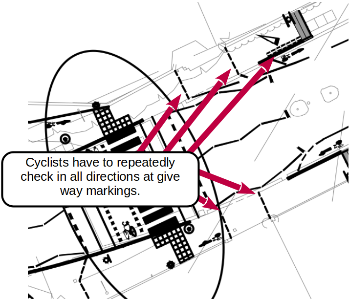
Issue No7. Parallel Cycle Crossings Require Drivers to See Cyclists Approaching Crossings Who Intend to Cross the Road. This is near Impossible with Cyclists Riding Parallel with the Road on a Cycle-Track Below the Minimum required DfT Widths for Shared Use and with no Separation Space between the Pavement and the Carriageway
DFT Traffic Signs Manual (First published 2019) Chapter 6 explains:
17.1.2. The same considerations of vehicle speed and flow apply as for Zebra crossings, and a Parallel crossing should not be placed on roads with an 85th percentile speed of 35mph or above without speed reducing measures. Cyclists travel faster than pedestrians, and as a Parallel crossing does not require them to stop and wait for a green signal as a Toucan does, good visibility is essential to ensure traffic can see cyclists in time to stop. Cyclists should also be able to see oncoming traffic in time to react, as they have no priority over other traffic until they are on the crossing.
17.1.3. If the pedestrian and cyclist desire lines do not coincide a Parallel crossing is unlikely to be suitable. The number and speed of cyclists will be a key factor in determining if a Parallel crossing is suitable. If there are very large flows of cyclists, but few pedestrians, a Parallel crossing may not be the best solution and a signal‑controlled facility using cycle only signals may be more suitable. A Parallel crossing may also be unsuitable if significant numbers of cyclists are expected to turn right from the main road onto the cycle route at this point.
Westgate carries the Long Distance National Cycle Route No2. This is also a utility cycle route regularly used by commuters. Cyclists riding this route have the expectation of meeting well designed DfT standards compliant cycle infrastructure where it is possible to safely make realistic progress in or out of the city. Westgate also carries many cyclists who are less experienced, leaving the city for family bike rides on Centurion Way.
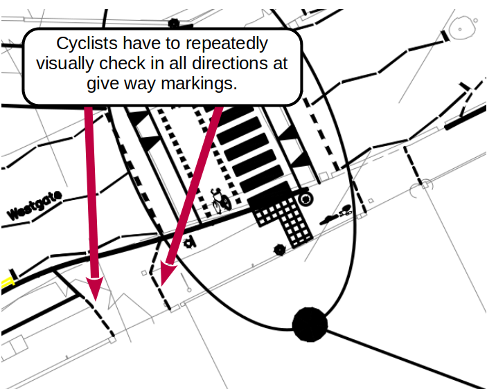
This TRO proposes to route cycle traffic over a parallel crossing on Sherborne Rd where visibility of approaching cyclists is obscured by two metre high brick walls and pillars. Cyclists making realistic forwards progress along the cycle track to this crossing, will emerge suddenly into the view of drivers leaving them with little time to react. Less experienced cyclists may be less aware of the limited visibility safety hazard presented by this proposed crossing. Students from Bishop Luffa School may attempt to make reasonable progress along this section of proposed cycle track.
There is only a 3 metre distance between the brick pillars obscuring visibility of approaching cyclists and from the kerb line of Sherborne Rd.
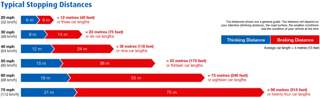
A cyclist travelling at speed of 14MPH will cover a 3 metre distance in a timespan shorter than half a second.
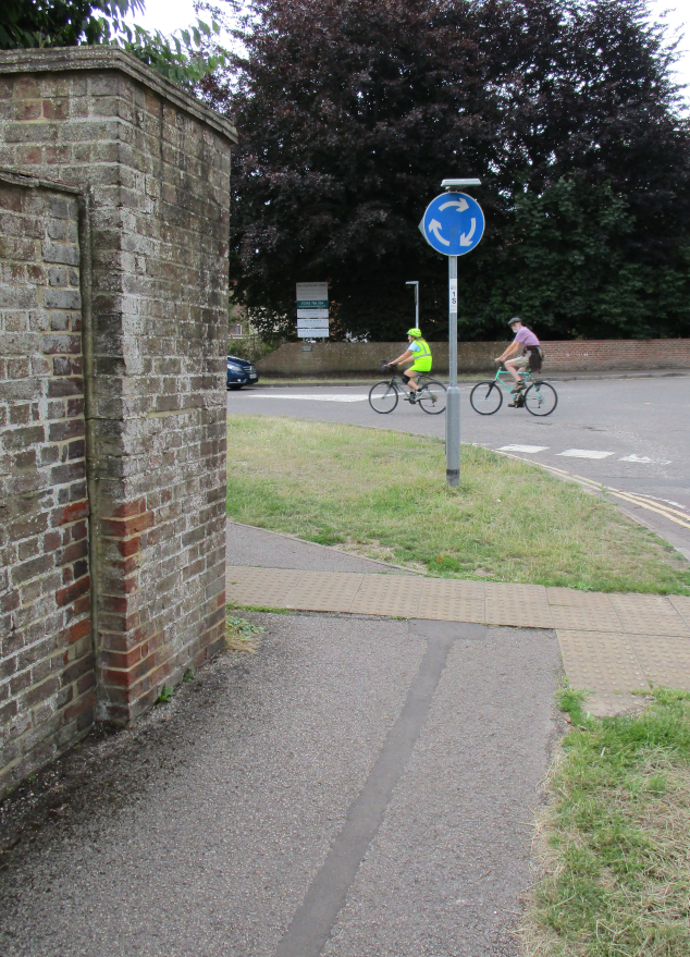
The limited visibility issue where cyclists will suddenly appear onto the proposed crossing after suddenly emerging from behind a tall brick wall and pillar, is illustrated in the photograph shown below.
The stopping distances given in the Highway Code indicate that drivers have an average reaction time in excess of half a second. Visibility of approaching cyclists will not be adequate for motorists to give way at the proposed Sherborne Rd parallel crossing.
DFT Traffic Signs Manual (First published 2019) Chapter 6 states:
17.2.7. Cyclists generally travel faster than pedestrians. On the approach to a Parallel crossing, if the cycle route joins the crossing at or near a right angle to the main road, this may lead to cyclists entering the crossing at an inappropriate speed, which could endanger themselves and intimidate pedestrians.
17.2.8. To ensure cyclists have sufficient time to assess whether there is a large enough gap in which to cross, and to allow drivers to see cyclists approaching and be ready to give way, the designer should consider how the cycle route layout can be varied to ensure cyclists do not enter the crossing too fast, for example, by deflecting the cycle route on approach. Pedestrian guardrailing for this purpose should only be used as a last resort and positioned with great care, as it can create conflict between cyclists and pedestrians, see 15.11.
Visibility issues at the proposed Sherborne Rd parallel crossing are compounded by two additional factors:
As drivers travel southbound along Sherborne road, approaching the mini roundabout, their attention will be focused towards traffic entering the roundabout from the right that they must give way to. However, the limited visibility of cyclists at the parallel crossing will require drivers to react rapidly to cyclists emerging from behind a wall and brick pillar from their left. It is unlikely drivers will be able to react quickly while looking in both directions at once.
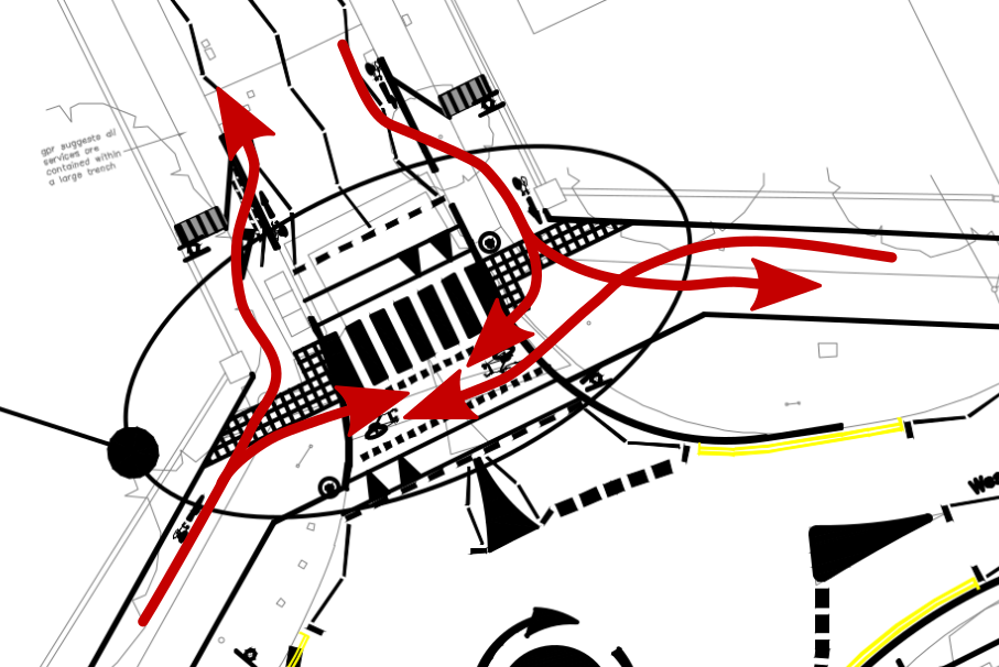
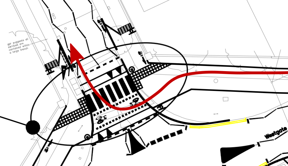
As cyclists approach the parallel crossing while riding on the pavement, motorists will be unable to predict if they intend turning across the crossing or carrying on riding along the pavement. This will leave drivers making split second decisions over whether they need to stop and give way or if they should continue forwards wthout stopping. The potential routes cyclists may follow at the crossing are illustrated in the following image. Drivers will need to consider all the potentially confusing manoeuvrers that cyclists could make when they approach the crossing.
Similar issues are present in the proposed design for a parallel crossing across Westgate. Because the proposed cycle tracks on Westgate pavements are significantly below minimum DfT widths for shared use, it will be even harder for drivers to predict if cyclists are about to turn to ride over the crossing, or if they will continue to ride along the pavement. The image below highlights the many potentially confusing manoeuvrers cyclists could make at the proposed Westgate parallel crossing.
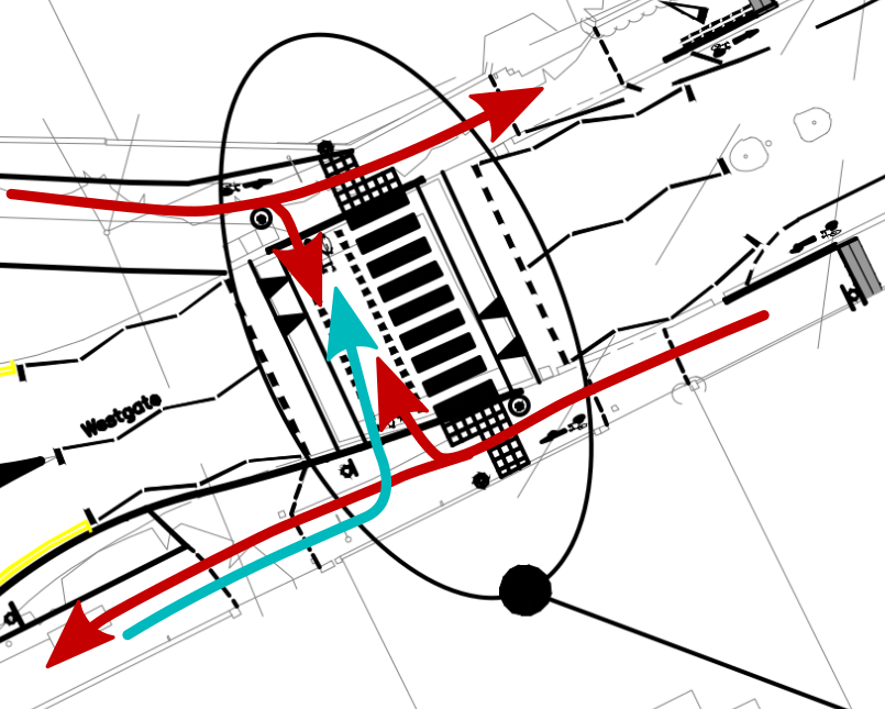
Because the cycle crossings are intended as a continuation of the cycle route running along Westgate itself, it seems likely most cyclists will choose to use the right of way at the crossings to turn right. However DfT advise that:
A Parallel crossing may also be unsuitable if significant numbers of cyclists are expected to turn right from the main road onto the cycle route at this point.
The issue with cyclists regularly wishing to turn right at the Westgate crossing is illustrated in the following diagram:
Similar issues will arise with cyclists wishing to turn right onto Sherborne road to head northbound.
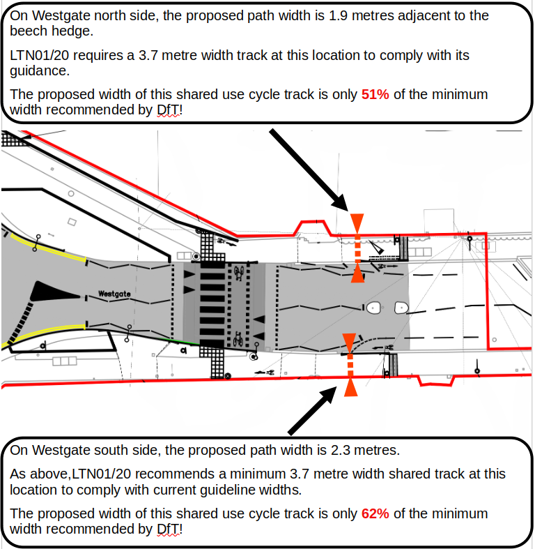
Issue No8. Unsuitably Narrow Pavements are Proposed for Conversion into Shared Use Cycle Tracks!
DfT Guidelines for Cycle Infrastructure Design LTN1/20 stipulate that:
Where a cycle track is bounded by a vertical feature, people will not be able to use the entire width as they will naturally be wary of riding immediately next to walls and kerbs. Designers should provide additional width as shown in Table 5-3.
As at Sherborne Road, on the north-side where there are adjacent features such as a two-metre vertical wall, LTN1/20 indicates additional width of 0.5 metres should be provided in addition to the 3 metres minimum recommended width for shared use paths. Total 3.5 metres.
The proposed scheme ignores DfT minimum width guidelines where shared use tracks are bounded by vertical features as illustrated in following two diagrams.
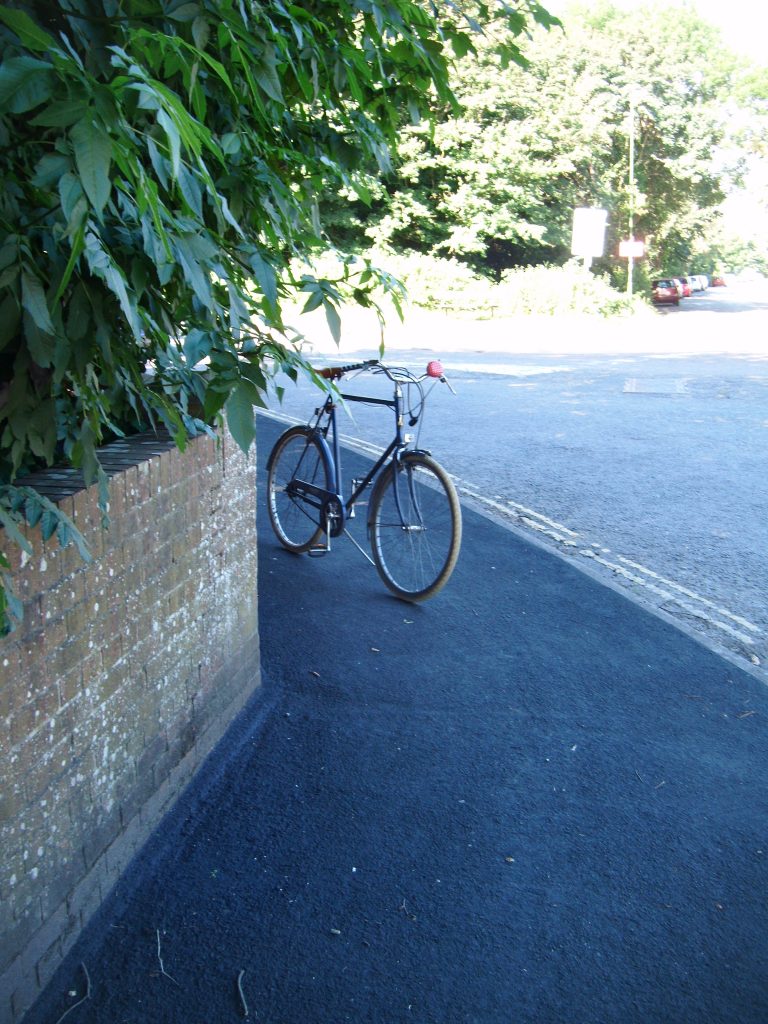
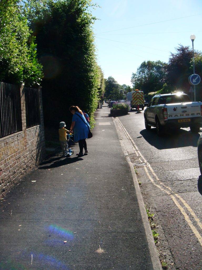
The TRO proposals runs a cycle track past a mature beach hedge that encroaches a long way over a pavement that is already below the specified width for shard use cycle tracks. The image below illustrates the narrow gap between the hedge and the kerb. It is difficult to imagine the adult and infant shown in the image below, sharing the space between the hedge and the road with fast moving morning commuter traffic including wide cargo bikes and parents pulling bicycle child trailers also using this pavement.
These design proposals fail to follow current advice given by all relevant DfT guidelines. This will result in discrimination towards vulnerable pedestrians in contravention of the 2010 Equality Act.
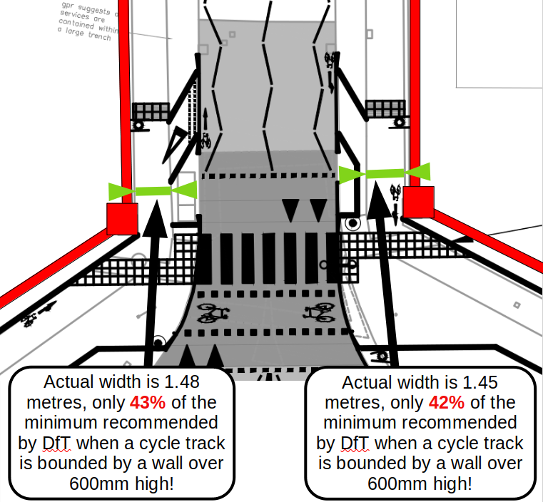
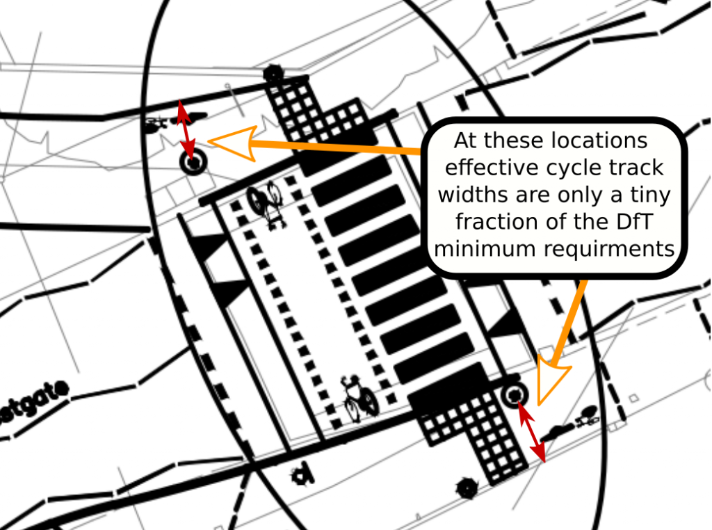
In positions where yellow globes are proposed at each end of the Westgate parallel crossing, significant difficulty will arise if these are mounted onto vertical posts rising up from the pavement. The effective width at this section of the shared use cycle track would then be only a tiny fraction of the DfT minimum for shared use facilities. This is illustrated in the diagram below.
Issue No9. Inappropriate road markings are proposed within parallel crossing control areas
DFT Traffic Signs Manual Chapter 6 states:
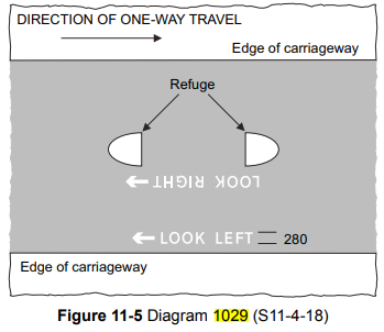
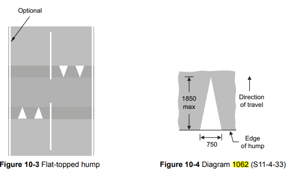
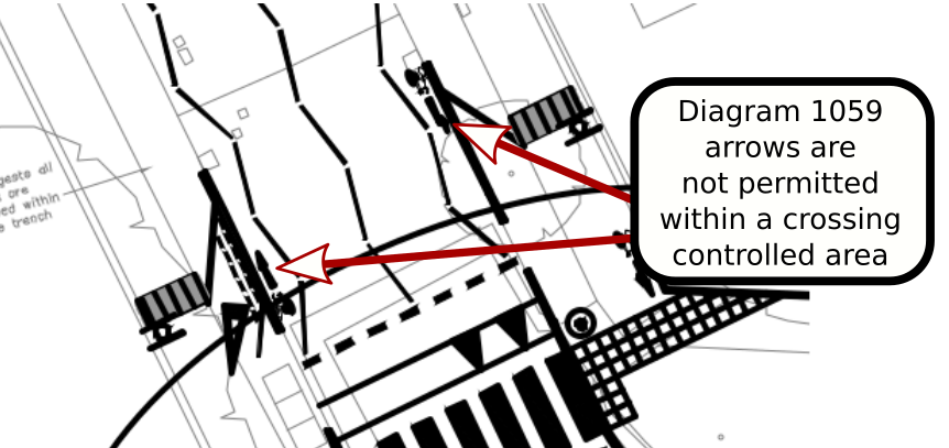
15.8.16. Markings to diagrams 1029 (S11‑4‑18) and 1062 (S11‑4‑33) may be used at or near a crossing. The use of diagram 1062 is described in Chapter 5.
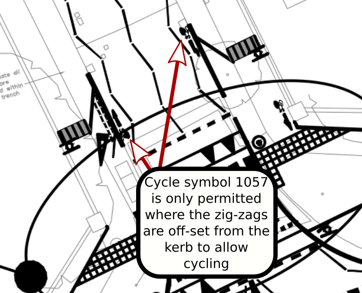
15.8.17. No other marking may be used within the controlled area, except hatched and chevron markings in the circumstances described in 15.8.4 and the cycle symbol to diagram 1057 where the zig‑zags are off‑set from the kerb to allow cycling.
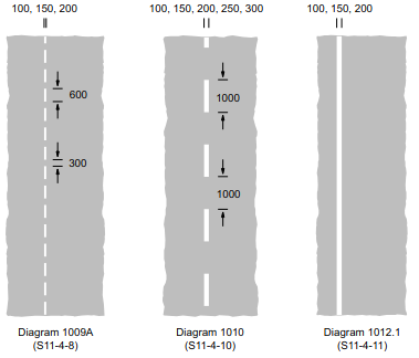
Examples of the permitted markings for use within crossing controlled areas are shown as follows.
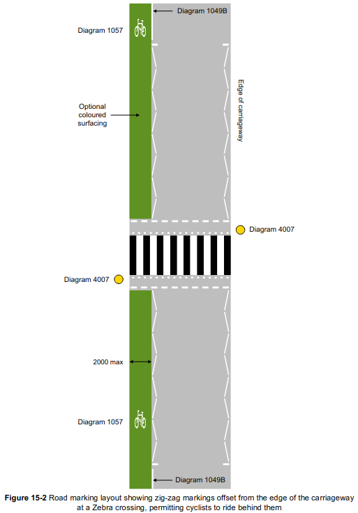
Diagram symbol 1057 may be used in conjunction with coloured tarmac to mark out a cycle lane.
diagram 1057 may only be used if the zig zags are offset to mark a cycleway
Diagram symbol 1029 may be used to remind pedestrians to look either left or right at a traffic island.
diagram 1029
Symbol 1062 is permitted only if marking a flat topped hump in the road
diagram1062
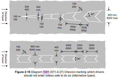
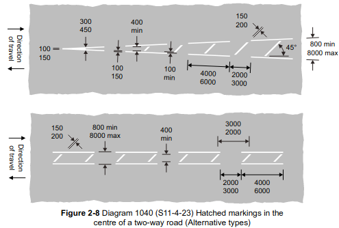
Hatched or chevron markings are only permitted in controlled area of crossings if they are between zig zags placed in the centre of the road to mark out islands!
DFT Traffic Signs Manual Chapter 6 states:
15.8.4.The Regulations permit the use of central hatched or chevron markings within the controlled area of crossings. Such markings may be used between a central double row of zig‑zags, but only in the following circumstances:
a)diagram 1040.2 may be used on the approach to a central reservation (including pedestrian refuge) of a single crossing in a two‑way road, and diagram 1041 in a one‑way road, and
b)diagram 1040.2 must be used on the approach to a staggered crossing.
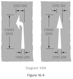
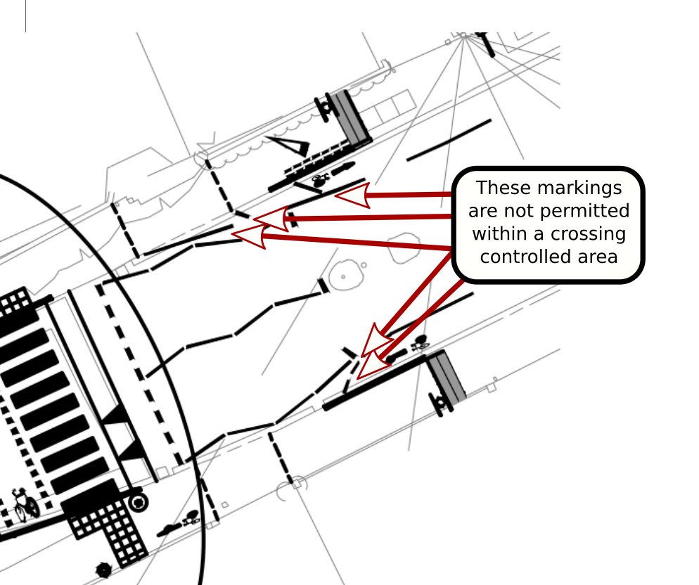
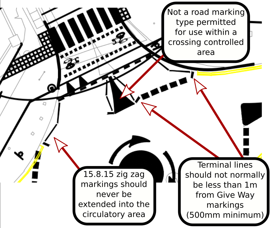
The following diagram symbol is not permitted for use within crossing controlled areas!
This symbol is not permitted within crossing controlled areas!
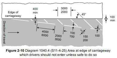
Hatched, chevron or edge of carriageway markings are not permitted between the outside carriageway kerbs and the outer zig zag lines that mark out crossing controlled areas. For example the following diagrams of markings symbols are not permitted around crossings.
These markings are not permitted between the outside carriageway kerbs and the outer zig zag lines that mark out crossing controlled areasThese markings are not permitted between the outside carriageway kerbs and the outer zig zag lines that mark out crossing controlled areas
Road marking issues are evident within the proposed Westgate parallel crossing control area. This is illustrated in the diagram below.
Road marking issues are also evident within the proposed Sherborne Rd parallel crossing control area. This is illustrated in the diagrams below. dft-traffic-signs-manual-chapter-6
If diagram 1057 symbols are to mark out a cycle lane running between the zig zag lines and the carriageway kerb, the absolute minimum width for the cycle lane width at any constraints is 1.5 metres. This requirement is given in LTN1/20 in table Table 5-2: Cycle lane and track widths.
DfT Traffic Signs Manual Chapter 6 (page 112) provides the following diagram of acceptable implementations of cycle lanes within crossing controlled areas.
Issues exist within the proposed plans where controlled area markings terminate close to the give way markings on the Westgate Sherbourne Rd roundabout. DfT Traffic Signs Manual Chapter 6 (page115) states:
15.8.12.Crossings on minor roads close to junctions will tend to restrict the layout of the controlled area markings. To preserve the effectiveness of a junction Give Way or Stop line, the terminal line of the zig‑zag markings should not normally be less than 1m from it. This distance may be reduced to 500mm if necessary to enable the minimum pattern of markings to be laid. The controlled area should never extend beyond the nearer kerb line of the major road. It should be the aim to provide room for at least one vehicle turning into the minor road to wait at the crossing without obstructing traffic on the major road. More vehicles should be accommodated if there are large numbers turning.
The issues with controlled area terminal markings is illustrated in the following diagram.


5 thoughts on “A Recommended Action, Oppose the Inappropriate Conversion of Westgate Pavements into Shared Use Cycle Tracks”