ChiCycle Perspective on the West of Chichester Development Southern Access Road
The Modification of the Road Network to Carry Motor Vehicle Traffic from the West of Chichester 1,600 Home Greenfield Development Site and also Indirectly from the B2178 Funtington Road, into the Heart of the Westgate/Parklands Residential Area of Chichester, is Inappropriate!
To view the virtual exhibition of plans for the outline planning for Phase 2 of the West of Chichester Development, you may follow this link: https://vpc.tetratecheurope.com/engage/westchichesterpart2/ a large downloadable PDF version is available here.
A large PDF file containing the 12 drawings accompanying the proposals is available here. An even larger version is available here.
Some FoCW members had trouble viewing this very large file showing all the drawings at once and we have some less detailed clips to give a quick view to those with less powerful PCs
Phase 2 Table Plans_reduced_en 1
Phase 2 Table Plans_reduced_en 2
Phase 2 Table Plans_reduced_en 3
Phase 2 Table Plans_reduced_en 4
Phase 2 Table Plans_reduced_en 5
Phase 2 Table Plans_reduced_en 6
Phase 2 Table Plans_reduced_en 7
Phase 2 Table Plans_reduced_en 8
Phase 2 Table Plans_reduced_en 9
Phase 2 Table Plans_reduced_en 10
Phase 2 Table Plans_reduced_en 11
Phase 2 Table Plans_reduced_en 12
A PDF containing notes of issues discussed with developers on the 8th July 2021 is available here ChiCycleConcernsSAR
ChiCycle believe the proposed plans deviate from accepted standards for walking and cycling
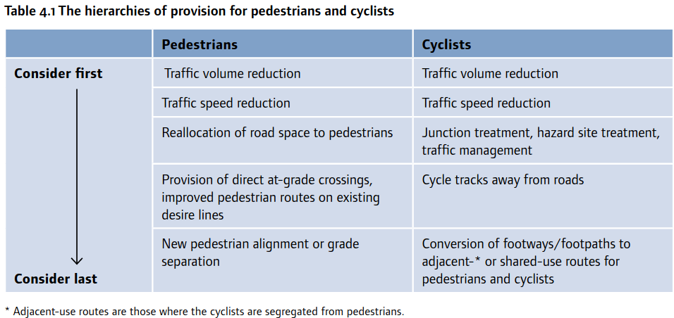
The Manual for Streets is the Department for Transports guidance on designing and modifying residential streets. The following recommendations are made regarding cycle and pedestrian safety
The hierarchies of provision 4.2.9: If road safety problems for pedestrians or cyclists are identified, conditions should be reviewed to see if they can be addressed, rather than segregating these users from motorised traffic. Table4.1suggests an ordered approach for the review.
The proposed Southern Access Road (SAR) will bring a significant traffic increase to both the western end of Westgate and to the southern end of Sherbourne Rd. This is the exact opposite of the most favoured approach recommended by the Manual for Streets.
Rather than reallocating road space to pedestrians as recommended by the Manual for Streets, it is being proposed that existing footways will be removed and converted into poor quality shared use cycle-tracks.
We need to be mindful that not only does Westgate carry significant local pedestrian and cycle traffic, bit it also carries traffic from two National Cycleways No 88 and No 2 in addition to the cycle traffic using Salterns Way.
ChiCycle have identified the following safety concerns for pedestrians or cyclists where the proposed SAR will run through Westgate and Sherbourne Rd:
- Cyclists will be relocated onto the pavements in the proximity of the Sherbourne-Rd/Westgate/Cathedral-Way junction. This will bring cyclists into direct conflict with pedestrians, particularly as the pavements are too narrow and have blind corners. This represents a significant reduction in provision for local pedestrians in this urban residential location. It will particularly disadvantage young pedestrians going to school, families using prams, shoppers using wheeled trolleys, disabled pedestrians with sensory impairment, dog walkers, those reliant on guide dogs, mobility scooter users, cargo-bike users. parents taking their kids to school using bike trailers, Cycle-without-age when using their trishaw and elderly or otherwise vulnerable pedestrians. ChiCycle believe relocating cyclists from the carriageway onto these pavements will be an infringement of the 2010 Equality Act.
- Relocating pedestrians onto shared pavements on Westgate will leave cyclists riding over blind driveways where drivers will have no visibility of approaching cyclists. This is will frequently cause cyclists to make sudden evasive maneuvers to avoid emerging cars causing additional problems for sharing the space with cyclists. Cyclists are at risk of being knocked into the road from the pavement by cars emerging from blind driveways. Cyclists knocked into the road in this manner are at extreme danger of experiencing secondary collisions with cars using the carriageway.
- Sherbourne Rd traffic volumes (as measured in March 2017) regularly run at around 4,000 vehicles per day. DfT LTN1/20 guidelines (page 33) describe this volume of traffic as “Provision not suitable for all people and will exclude some potential users and/or have safety concerns“.
- The central section of Westgate regularly sees weekday traffic volumes running at over 5,000 vehicles per day. DfT LTN1/20 guidelines (page 33) describe this volume of traffic as “Provision suitable for few people and will exclude most potential users”.
- The existing pavements on Westgate and Sherbourne Rd proposed for conversion into shared cycle tracks, are below acceptable widths given in DfT LTN1/20.
- The SAR cycleway ends at an uncontrolled crossing immediately next to Cathedral Way roundabout. The National Speed Limit of 60Mph applies to the Cathedral Way roundabout and the speed limit only reduces to 20 Mph in the immediate vicinity of the proposed crossing. Traffic on this arm of the Cathedral Way roundabout will carry traffic for Sherbourne Rd itself and in addition traffic from both Westgate and the proposed SAR. This indicates very high traffic volumes are to be anticipated at this un-signalled crossing. LTN1/20 illustrates crossing design suitability with the following table.
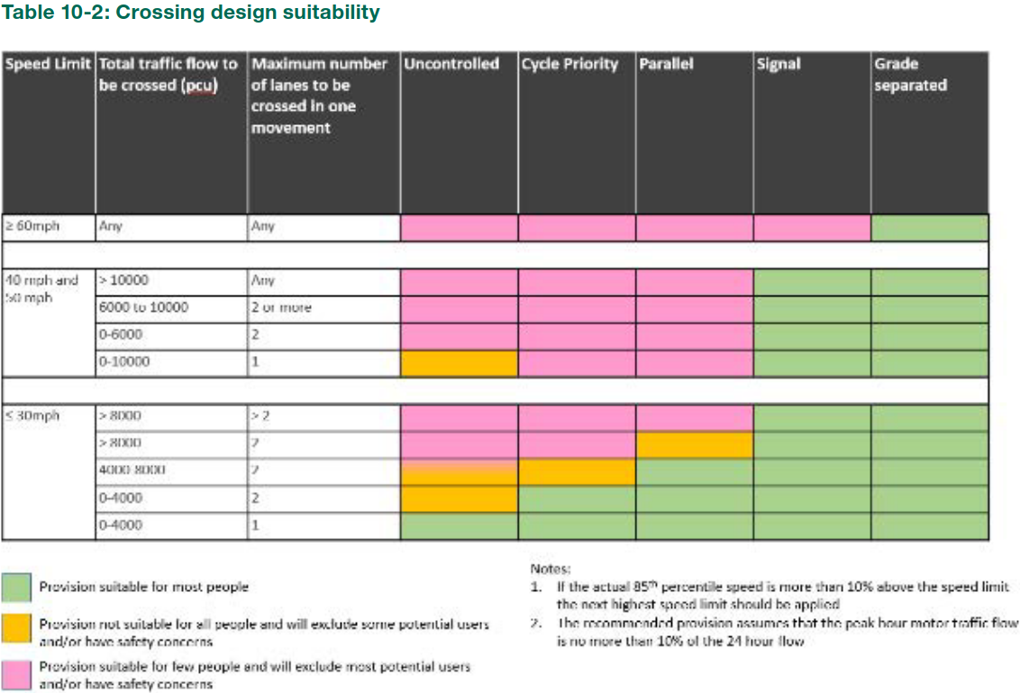
The table above indicates an uncontrolled crossing at this location will only be suitable for most people if the traffic volume is below 4,000 PCU per day where the peak hour traffic flow is no more than 10% of the 24 hour flow. These low traffic volumes are unlikely to be achieved with the currently proposed SAR design. - There will be no reasonably accessible alternative routes allowing vulnerable pedestrians to avoid using the proposed shared use cycle tracks on the pavements!
The purple dots in the diagram show the existing pedestrian route from the railway foot bridge at Bishop Luffa school towards the Market Cross. If the proposed scheme goes ahead, elderly, disabled pedestrians who fear collision with bikes will have to take a long detour to use alternative, safe pavements and paths. The shortest realistic alternative route is shown by the green dotted line.
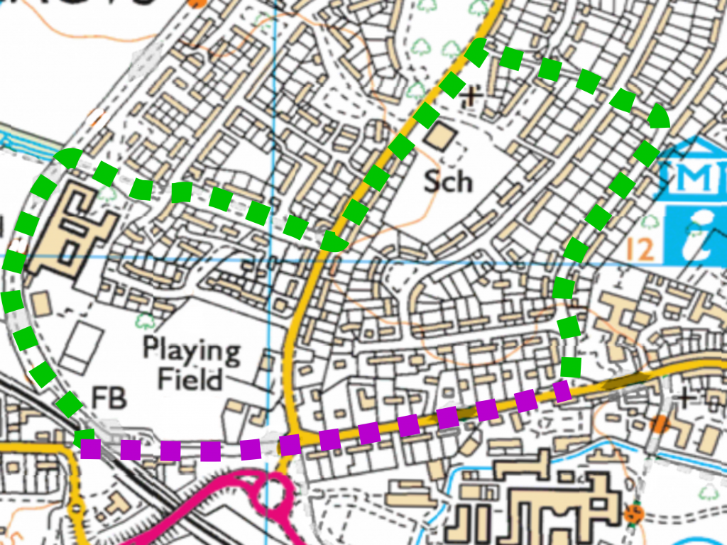
The green route that would avoid conflict with bikes on narrow shared use pavements, is over 1.15 km longer than the direct route shown in purple. Centurion Way mostly complies with existing DfT standards so it is possible some elderly or disabled pedestrians might be confident walking the route shown by green dots.
ChiCycle demand alternative Transport Network Solutions be Considered that would Enable Parklands and Westgate to become Low Traffic Neighbourhoods.
The concept of UK Low traffic neighbourhoods borrows heavily from European and particularly Dutch urban design expertise in road safety. Although there is often a degree of initial opposition to such schemes, there is evidence that once implemented a majority of people accept them as genuine and worthwhile improvements. Once established, most residents wish to retain them. Urban residents often live with the misconception that the existing volume of local motor traffic is essential to healthy community life. They fear that measures to curb motor vehicle use will restrict peoples ability to accesses local shops and services. However, once low traffic neighbourhood schemes are implemented, the remarkable phenomena of evaporating traffic takes place and residents find themselves living happily in a more pleasant and community orientated environment.
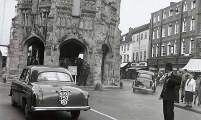
Indeed, schemes to reduce traffic are not historically unique within in Chichester. The A259 was once the main Sussex coastal road which ran over a level crossing at Westgate before leading through the centre of the city. It was necessary for it to do an awkward wiggle to squeeze around the Market Cross. A bypass was built in the 1930s but the A259 remained a route through the centre of the City until the pedestrian precinct was created in the 1970s. Cars driving past the market cross can be seen in the image below.
Only in in 1983, did an Act of Parliament authorise construction of
Cathedral Way and the diversion of what is now Fishbourne Road East.
At the same time the Westgate railway level crossing was closed to motor traffic an it became a crossing for pedestrians and cyclists only.
The closure of the Westgate level crossing to motor traffic created a Quiet Street at the western end of Westgate. As motor vehicle traffic levels increased in other parts of the city with the construction of the Chichester and Havant A27 bypass, the route along Westgate became the only realistic passage to the west of the City for pedestrians and cyclists.
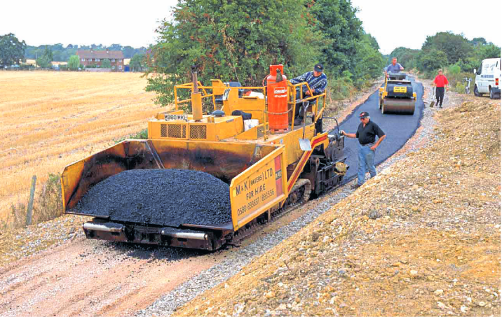
With viable walking and cycling connections through Westgate to the west of the City, several cycle routes have developed. Firstly Centurion Way was built along the route of the disused Chichester to Midhurst railway in 1995. An image of it’s construction is shown below.
Salterns Way is a 12 mile cycle route from the centre of Chichester to the sand dunes of East Head. It relies on Westgate being a navigable route for family cyclists and its success owes much to Louise Goldsmith’s determination to create a wonderful cycle route in and around Chichester Harbour.
Visionary Town Planning Decisions and Projects of the 1970/1980s Successfully Quietened Chichester’s Historic Streets and helped Popularised Walking and Cycling. To Reversing these interventions is a Retrograde Step we must Urgently Reconsider in this Period of Climate Emergency.
Breaking the convenient passage for cyclists who pass through Westgate is undesirable. The proposed introduction of the Southern Access Road servicing 1,600 new homes, will result in a severance of this cycle route. This goes against the policy guidelines in the National Planning Policy Framework (NPPF). This situation is made even worse by relocating cyclists onto unsuitable pavements. This will leave the connections along Westgate for pedestrians and cyclists inadequate for both groups of road users. The NPPF states the following:
109. Development should only be prevented or refused on highways grounds if there would be an unacceptable impact on highway safety, or the residual cumulative impacts on the road network would be severe.
110. Within this context, applications for development should:
(a) give priority first to pedestrian and cycle movements, both within the scheme and with neighbouring areas; and second – so far as possible – to facilitating access to high quality public transport, with layouts that maximise the catchment area for bus or other public transport services, and appropriate facilities that encourage public transport use;
(b) address the needs of people with disabilities and reduced mobility in relation to all modes of transport;….
It should be noted that the proposed conversion of unsuitable urban pavements to shared use will particularly discriminate against people with disabilities and reduced mobility.
The national policy on walking and cycling also demands the highest standards of convenience and safety for walking and cycling for new housing developments. The policy document Gear Change states on page 26:
We will ensure that all new housing and business developments are built around making sustainable travel, including cycling and walking, the first choice for journeys
The purpose of the planning system is to contribute to the achievement of sustainable development. We expect sustainable transport issues to be considered from the earliest stages of plan-making and development proposals, so that opportunities to promote cycling and walking are pursued. Planning policies should already provide for high quality cycling and walking networks, green spaces and green routes, and supporting facilities such as cycle parking (drawing on Local Cycling and Walking Infrastructure Plans). While many local plans already say the right things, they are not always followed consistently in planning decisions. Developments often do little or nothing meaningful to enable cycling and walking. Sometimes they make cycling and walking provision worse. We want new developments to be easily and safely accessible and navigable by foot and bike, and to make existing cycling and walking provision better………… One of Active Travel England’s functions will be as a statutory consultee within the planning system to press for adequate cycling and walking provision in all developments of over a certain threshold, and provide expert advice on ways in which such provision can be improved. We will work with Active Travel England and other key stakeholders to ensure that the importance of securing high quality cycling and walking provision is embedded within the planning system………….
The ChEmRouteVision offers a high quality transport solutions that can improve local journeys made by all road users. It also provides opportunists for Westgate, Parklands and the Harbour Villages to become Low Traffic Neighbourhoods
![]()
An important feature of the ChEmRouteVision is that it calls for a proper assessment of current and future transport needs to be assessed before hard to reverse changes to are implemented. Robust transport surveys are necessary to enable design of high quality infrastructure that is both future proof and compliant with DfT standards for highway design.
It is not possible for ChiCycle (or indeed anyone else) to produce a firm credible proposal for transport network interventions until adequate transport research has successfully been conducted. It is also unreasonable for the SAR to be connected at Sherbourne road when the existing infrastructure is proving inadequate even for existing levels of traffic.
However, ChiCycle will soon produce drawings and sketches of transport network interventions indicative of the type of solutions that could resolve both existing local transport issues and those created by new development.