Dear Mr Record
Thank you for your email regarding the Chichester to Emsworth Non-Motorised User (NMU) route.
Firstly, may I apologise for the length of time it has taken to respond to your letter.
As you are aware, we are currently in the process of procuring a design partner to progress the recommendations of the WSP feasibility study for a shared path on the northern side of the A259 between Chichester and the border with Hampshire. We currently hope to have them on board for a start to their commission in September.
As you will appreciate, the layouts detailed in the feasibility study are high level. The next stage will involve working these up in further detail and considering both localised constraints and compliance with the specified design standards (both our own DMRB and the West Sussex cycle design guide). Any design outputs will be subject to safety audits and technical reviews during the course of the design lifecycle.
We will be providing our designers with a copy of all comments received on the feasibility study from stakeholders to ensure they take on both local knowledge and any technical concerns raised. We will also be working with West Sussex County Council throughout the design process to ensure the design meets their needs as both local highway authority and asset owner.
Finally, with regards to your comments on town planning, I note your points but will decline commenting on these as they are local matters for the local authorities and I note you have written to them separately with your list of concerns.
Kind Regards
Simon Elliott
Simon Elliott BEng(Hons) CEng FCIHT DMS NEC3&4 ECC Accredited PM
Programme Manager (Construction) – Regional Investment Programme South East
Highways England | Bridge House | 1 Walnut Tree Close | Guildford | Surrey | GU1 4LZ
Web: www.highwaysengland.co.uk Mobile : 07901 110659
Dear Highways England A27 designated funds team,
ChiCycle are delighted that funds and planning efforts are being invested into walking and cycling infrastructure between Chichester and Emsworth.
However, we are reluctant to support the designs within the feasibility study because they involve relocating cyclists onto the pavement in built up areas. This will result in a significant reduction in provision for both cyclists and pedestrians alike.
Please find a detailed list of our concerns, observations and recommendations at the end of this correspondence, that we hope will be considered during the further development of this scheme.
ChiCycle would welcome an assurance from you, that plans to put fast two way cycle traffic onto the pavement, in built up areas, with the cycle-way running on a single side of the road, will be thoroughly reconsidered.
Please let us know how you intend to review and revise the existing designs. Ideally we would like a statement that you are happy for us to share by publishing on our website.
Thank you in advance for sharing your intentions,
Mark Record (on behalf of ChiCycle)
ChiCycle Concerns, Observations and Recommendations regarding the Highways England Designated Funds A27 Link Improvement Package Feasibility Study Plans
30 kph Commuter/Utility Cycle Traffic on Shared Use Pavements will Threaten Vulnerable Residents
DMRB CD195 Designing for cycle traffic (page 17) recommends a cycle-way design speed of 30 kph. It indicates an absolute minimum design speed of 20 kph. However, the standards states this minimum speed can only be applied over a short distance:
E/3.17 Absolute minimum values for cycle track design speed shall only be used for distances up to 100 metres.
E/3.17.1 Where absolute minimum design speed values are used for cycle tracks, ‘SLOW’ markings should be included.
30 kph will be an intimidating speed of traffic for vulnerable residents sharing the pavement. Parents may be discouraged from walking young children to school, choosing to make these journey by car instead. This may force a car-dependent lifestyle on the very youngest members of our community. Frail elderly residents may also lose the confidence to go shopping locally when fast moving cycles are relocated onto the pavement. This could prevent elderly people living independently. People with sensory impairment may feel particularly at risk.
The Equality Act
1.13 Shared use schemes are often implemented to improve conditions for cyclists, but it is essential that they are designed to take into account the needs of everyone expected to use the facility. Poorly designed schemes, and schemes where the available width is insufficient to comfortably accommodate the expected flows of pedestrians and cyclists, are likely to reduce the amenity value of the route.
1.14 Disabled people and older people can be particularly affected by shared use routes. Ultimately, however, it will depend on the quality of the design. Consideration of their various needs is an important part of the design of shared use, and the duties under the Equality Act 2010 are particularly relevant.
ChiCycle are concerned that removing existing cycle lanes from the carriageway and re-locating fast cycle traffic onto existing pavements will represent a significant reduction in the quality of provision for both pedestrians and cyclists alike.
Our recommendation is to preserve the existing pavements/footways for pedestrian use only.
Feasibility Study Incorrectly Relies on CD195 Specifications for Shared Use Pavements/Foot-ways
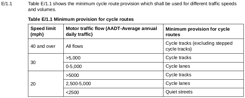
To determine the required widths of proposed cycle infrastructure, based upon peak hour cycle flow, reference has been made to Table E/3.1 of the Highways England guidance. Table E/3.1 has been re-produced below in Figure 5-3.
The Introduction of CD195 makes the following statement:
This document refers to the provision for cycle traffic only which allows for a higher design speed when separated from pedestrian and equestrian traffic.
Chapter 1 of CD195 clarifies that the scope of the document excludes shared use paths.
1. Scope (Aspects covered)
1.1 This document shall be used for the design of routes and assets used by cycle traffic.
NOTE This document does not cover the design of shared use facilities for pedestrians, equestrians and cyclists.
ChiCycle observe that CD195 recommendations have been inappropriately applied and therefore falsely indicate a shared use pavement might be an appropriate solution in built up areas. This mistake casts doubts over the conclusions of the entire study. We recommend the proposal of reallocating pavement space for shared use is reconsidered.
E/4.7 Cycle tracks which intersect the minor road at priority junctions shall cross the minor road in one of two ways – either bent-out or bent-in crossings.
The “bent in” method is not appropriate for use with two way cycle tracks.
E/4.16 Cycle tracks at bent-in crossings shall be one-way.
ChiCycle doubt there is adequate space in the built the up areas to “bent out” the cycle track by a minimum of 5 metres at all access roads and minor junctions .
E/4.15 At bent-out crossings, where cycle tracks cross minor private access roads carrying less than 2000 AADT, there shall be a minimum set-back distance of 5 metres.
ChiCycle recommend stepped cycle tracks as a more appropriate solution. CD195 indicates stepped cycle tracks are acceptable as long as a speed limit of no more than 30 Mph is applied where they are employed.
Table shows a stepped cycle track is a suitable solution even with the high 15697 AADT traffic flow of the A259.
LCDS Recommends Against Running Two-Way Cycle Tracks Across the Mouths of Side Road Junctions
LCDS Ch5 Junctions and crossings (Page 25 – Priority junctions) gives design advice on side road junctions for two way cycle tracks that is similar to that given in CD195.
For two-way tracks crossing two-way side roads, ‘bending-out’ by 5 metres is the recommended option. Where island separation is wide, this can be achieved with little or no deviation of the cycle track. Continuing a two-way track through a priority junction without deviation is possible, but brings with it various risks, related to the visibility of cyclists to turning motorised traffic. It is not recommended unless traffic speeds and volumes are very low and other measures can be put in place to enhance visibility of cyclists – even then, it should be subject to a site- specific risk assessment. Closing side streets to motorised traffic is likely to be the only reliable way of dealing with these risks.
LCDS recommend that if a two way cycle track can not be “bent out” at junctions the only reliable way of making the arrangement safe is to close the side streets to motorised traffic!
The Feasibility Study may have considered the use of two way cycle tracks parallel to the road due to the misconception that this arrangement requires the least highway space to accommodate it. However CD195 and LCDS both include bending out the cycleway by 5 metres where cycle tracks cross minor roads or access-ways. ChiCycle consider the proposed two-way cycle track an inefficient use of available space due to the requirement of bending out the cycle way at each junction/access-way.
For these reasons ChiCycle recommend that in built up areas, either stepped cycle tracks should be provided on both sides of the road or alternatively traffic volumes and speeds should be reduced to levels where cyclists can safely share the carriageway with motorists.
Proposed Plans Require Properties Adjacent to the Cycle Track to Limit Boundary Heights to 600mm for Visibility Splay Compliance
DfT LTN 02/08 Section 9.1 (page 53) explains visibility requirements at junctions and crossings of cycle tracks. It states:
9.1.1 Where a cycle track meets a road, visibility splays are required to ensure cyclists can see and be seen by approaching motorists. Splays are defined by their X and Y distances, and Figure 9.1 shows the
basic layout. Figure 7.18 in the Manual for Streets (DfT/CLG, 2007) (MfS) shows how splays are measured on curved alignments.
Boundaries of properties immediately adjacent to the cycle track will need to be free from visual obstructions. This is so motor-vehicles at junctions or vehicles emerging from driveways can see and give way to cyclists before pulling out into approaching cycle traffic. A 31 metre SSD is recommended for 30 kph design speed cycle tracks which will be the Y distance a motorist would need to see oncoming cyclists in advance of pulling out across the cycle way. Maintaining adequate visibility will require boundary planting, fencing and walls on private properties, being brought down and maintained at below the DfT recommended height of 600mm.
ChiCycle are concerned residents may be reluctant to comply with requests to modify their front gardens and that future policing of these visibility requirement may prove difficult to enforce.
All Current UK Highway Standards Recommend Against Converting Pavements to Shared Use for Two-Way Long Distance Commuter/Utility Cycle Routes running through Built Up Areas
4.6.3 – Partially separated and shared use footways are not generally recommended alongside the carriageway where there are better ways of providing for cyclists. They suffer from many of the drawbacks outlined for equivalent off-road facilities in section 4.5 above, with regard to compliance, compromising pedestrian comfort and deterring use by many people who find sharing with cyclists intimidating, including people with mobility or visual impairments. They also represent a low level of service for cyclists.
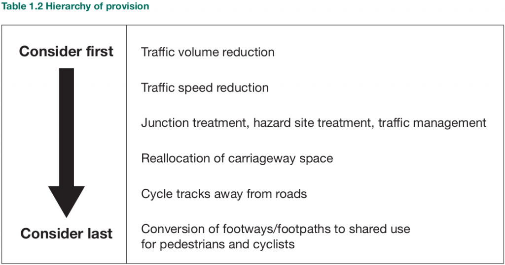
DfT LTN 02/08 (page 10) Table 1.2 Outlines a hierarchy of provision intended to ensure that the needs of the most vulnerable road users are fully considered in all highway schemes.
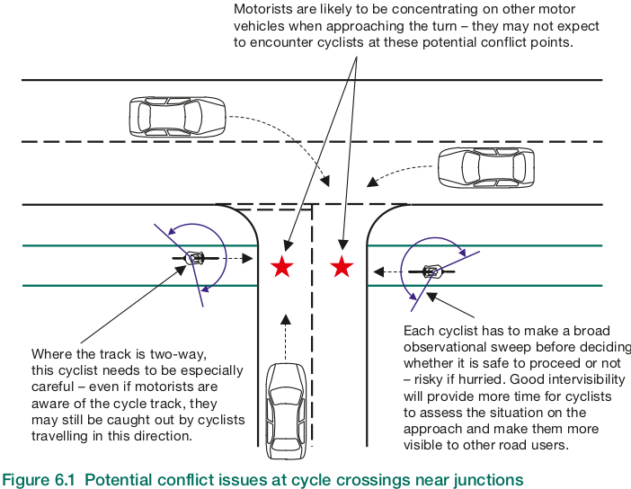
6.12 A common reason for taking cyclists off the carriageway is the perception that it will improve safety. However, it is important to understand that a shared use route will not necessarily be safer than an on-carriageway alternative. In particular, careful consideration is needed where a cycle track running alongside a road crosses side a road – see Figure 6.1. At these locations, there is significant potential for conflict, which can sometimes negate the safety benefits of segregating cyclists from motor vehicles. Section 10.3 of LTN 2/08 discusses this in greater detail.
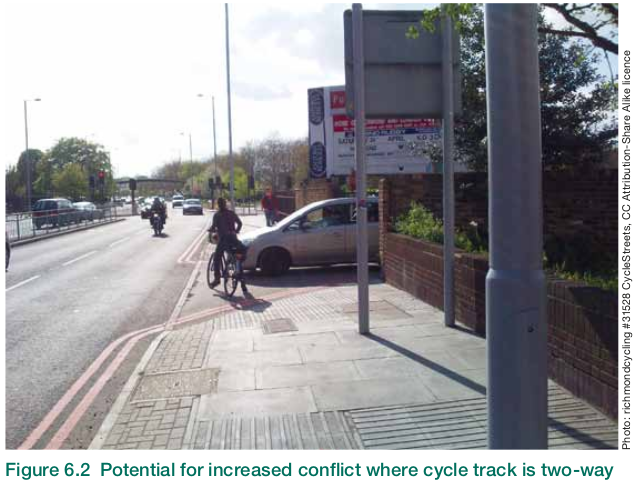
6.13 Where cycle tracks alongside roads accommodate two-way flow, the potential for conflict can increase significantly. It is probable that drivers are less likely to expect cyclists to come from both directions because, intuitively, they might assume cyclists would be travelling in the same directions as traffic in the adjacent part of the carriageway – see Figures 6.1 and 6.2.
Reallocation of road space. A fundamental aspect of the provision of cycling facilities is the reallocation of carriageway from motor vehicles to cycling. This can be seen in the majority of figures within this document. The provision of cycle tracks in urban areas at the expense of the footway is not encouraged (it tends to be unpopular with pedestrians and cyclists)
Routeing the South Coast National Cycleway along pavements, through built up areas, will prove counter productive to road safety. Motorists often show aggression towards cyclists who choose not to use poor quality cycle provision. This aggression is frequently accompanied by dangerous driving endangering cyclists. West Sussex already contains many examples of unsuitable cycle schemes that cyclists normally bypass by riding in the roadway.
If national cycle design standards are ignored, the Designated Funds A27 Link Improvement Package risks becoming a waste of public money. It may then produce unusable and useless infrastructure that the community do not want to see constructed.
ChiCycle advise that the A27 Designated Funds should only be spent on high quality, national standards compliant (preferably CD195) infrastructure. This will enable the uptake of safe, convenient and confident cycling along the South Coast National Cycle-route.
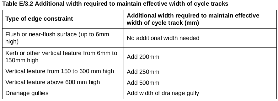
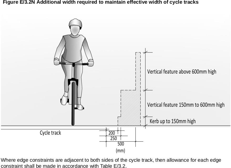
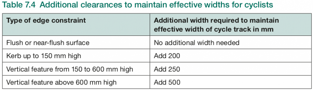
Plans Confuse Actual Widths Measured between Vertical Features with Recommended Usable Effective Widths Prescribed by National Cycle Standards
ChiCycle have surveyed sections of the A259 pavement and concluded that there has been a misinterpretation of national cycle design guidelines regarding usable track widths. Widths shown in the Feasibility Study appear not to make allowance for the vertical features adjacent to the path such as boundary walls and hedges.
As already discussed DMRB CD195 Designing for cycle traffic does not contain any specification for shared use pavements/footways. However, even if pedestrians could be removed from the pavement to make way for a dedicated cycle-way, then the standards for track widths have still been misapplied.
E/3.2 Additional width shall be added to cycle tracks to make allowance for fixed objects adjacent to or within the cycle track in accordance with Table E/3.2.
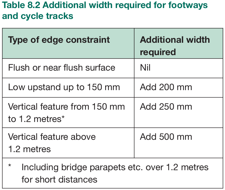
DfT LTN 02/08 (page 43) Table 8.2 Additional width required for footways and cycle tracks gives similar guidance:
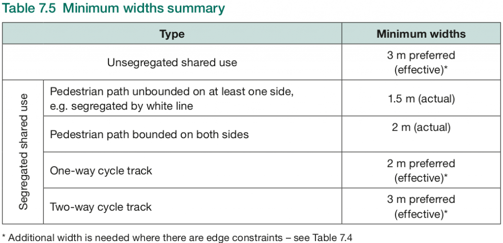
Although DfT LTN 1/12 Shared Use Routes for Pedestrians and Cyclists indicates a shared pavement is an inappropriate solution for carrying the National South Coast Cycle Route, it is the current specification to follow for designing shared use paths in situations where shared use is advisable. It gives the following specifications in LTN 1/12 Table 7.5 & 7.5 (Page 43 – 44):
ChiCycle are unable to replicate LCDS Cycle Level of Service (CLoS) analysis figures shown in Feasibility Study report
Details of the studies LCDS CLoS scoring for existing infrastructure was given in Appendix A, but the report omits detailed scoring analysis of Option-1 and Option-2. ChiCycle performed their own CLoS analysis for link number 4 for Option-1 (Southbourne to Farm Lane) but have been unable to replicate similar score to that reported in the feasibility study.
The Feasibility Study awards Option-1 link number 4, an extremely high CLoS score of 85%. Several legitimate concerns resulted in the existing infrastructure on the same section, being awarded a low score of only 24%. There are a number of scoring issues we are unable to follow:
The existing traffic arrangement is marked as a critical fail due to “Heavy streams of turning traffic cut across main cycling stream”. However, it is not clear how moving cyclists onto the pavement will resolved this issue.
Another critical fail identified in the existing arrangement is “Cycle Lanes <1.5m alongside parking loading with no buffer. This raises the issue of conflict with “Kerbside activity or risk of collision with door”. Because CD195 requires two way cycle tracks to be divided into opposing direction lanes, Option-1 presumably will have a lane less than 1.5 meters wide, adjacent to the kerb where “collision with door” are to be expected. It is also difficult to see how a cyclists riding on a pavement might be isolated from kerb side activity?
Option-1 fails to provide the convenience or directness of a route absent from frequent road crossing or free from obstruction from other road users, so it is difficult to understand how a CLoS scoring of 85% has been calculated. DfT LTN 02/08 states that:
8.2.1 On commuter routes, cyclists usually want to be able to travel at speeds of between 12 mph and 20 mph, preferably without having to lose momentum. Frequent road crossings, tight corner radii, the presence of other users and restricted width or forward visibility all affect the speed with which cyclists can travel and the effort required. Cyclists tend not to favour cycle routes that frequently require them to adjust their speed or stop.
ChiCycle recommend future CLoS assessments are conducted with input from the community of cycle users in the area. A full cycle audit and review should also be conducted with the input of local cycling groups following the recommendations of DfT LTN 02/08 1.7 (page 15).
Scope of the Cycle-way Improvement Scheme may be too Narrow and Ignores Wider Aspects of Town Planning.
There are a significant number of housing developments under construction in the South East of England with significant pressure from National Government to build even more. Fishbourne, Nutbourne, Bosham and Southbourne are small village high streets that could become appealing local centres. However for the street scene of these villages to remain appealing as local centres, something needs to be done about the increasing volume of traffic travelling on the A259.
The expansion of housing will bring an associated rise in local population. This seems likely to increase motor vehicle use still further unless steps are taken to mitigate against it. With the A259 being the main conduit for local traffic between Chichester and Emsworth it is difficult to imagine the small villages retaining an appealing sense of place with increasing traffic flow along the A259. Perhaps solving this problem requires stepping back from the narrow details of cycle track specification and considering wider issues from the alternative perspective of town planning.
ChiCycle have the following town planning recommendations for the A259 corridor between Chichester and Emsworth.
Provide employment, shops, schools and other local amenities to reduce the need for motor vehicle journeys.
Improve the convenience of public transport by providing more train stations, more frequent trains or a parallel tram service. This will provide viable alternatives to journeys by car.
Expand and improve the cycle network in the region to provide further alternatives to motor vehicle dependency.
Provide local roads with new access connections onto the A27 to relieve village centres from heavy traffic. If there must be an increase in motor vehicle use then infrastructure will be needed to divert this traffic away from the National South Coast Cycle Route and the villages/communities it connects together.
If it is not possible to reduce traffic volumes on the A259, an alternative, direct and high quality cycle route should be constructed parallel to the railway line.
Conclusion
The transport sector is now the UK’s greatest contributor of CO2 emissions. It is generally accepted that unless global CO2 emissions are halted by 2030, there will be a bleak future for humanity. ChiCycle also believe getting around by bike is more health and fun than a sedentary lifestyle with hours spent stuck inside stuffy motor-vehicles. Considering the urgency of Climate Crisis, ChiCycle hope the Designated Funds A27 Link Improvement Package plans can be reconsidered to include something more aspirational and appealing than cyclists riding on existing pavements. At this time of Climate Crisis it is vital we move away from unsustainable motor vehicle dependency and embrace sustainable modes of transport.
I hope this provides a constructive input to the Designated Funds A27 Link Improvement Package scheme,
Mark Record (on behalf of ChiCycle)
A copy of this email has now been sent to (Simon Elliott Programme Manager Regional Investment Programme South East Highways England)
4 thoughts on “Open Letter to Highways England regarding the Chichester to Emsworth Cycle-way”
WSP consultants have done quite a good analysis of the problem, but I agree their first iteration of the solution isn’t right. Having spoken to quite a few people now, I have come round to the conclusion that a two-way shared pavement on the North side doesnt work, even if priority over all side roads was an absolute pre-requisite.
The long term aim must be to increase the percentage of journeys taken by bike from its current paltry level to about 40% of all short journeys under 8 miles. This gets people out of cars and could even improve car journeys by preventing the gridlock. Without this sea-change in cycle use, it is inevitable that all the new housing along the A259 corridor will create traffic jams.
At the same time cycle lanes need to be safe. Currently 40% of all serious accidents along that stretch of the A259 involve cars hitting bikes, totally disproportionate to the number of bike journeys. What we need is a dedicated cycle lane on both sides of the road that is protected from car traffic and separate from pedestrians. This can be done by joining up and segregating the existing cycle lane sections, so long as roadside parking is banned. If necessary take real estate from the car lanes. It should start at Emsworth roundabout, go directly along the route of the A259 with priority over all side roads, driveways, bus-stops lay-bys (i.e. the same as cars travelling on the main road). The surface must be smooth so a fast road bike can get up speed and not be tempted by a smoother surface on the main road. It should be raised slightly, partly so that cars are not tempted to use it, partly so that any standing water drains onto the main road. It should not have any diversions through Emsworth square or round the back of Fishbourne, otherwise it won’t be used.
In rare cases where the car lane and bike lane is shared, then traffic calming must be introduced. It must be a ’20 is plenty’ zone so that the speed differential is minimal. I am thinking of Westgate and possibly Fishbourne if segregated cycle lanes would make the road too narrow to be viable. There are lots of different forms of traffic calming that don’t involve speed humps: Chicanes, plant pots in the middle of the road, even different colour tarmac. Emsworth square is a good example: You can cycle there quite safely, saunter across the road and there isn’t a zebra crossing or speed hump anywhere in site. It somehow just works, and creates a pleasant atmosphere to live.
I hope all the various interested parties can agree on a unified position, but we must come up with an alternative solution that does work.
Thanks Andrew,
Improving the South Coast National Cycle Route presents a challenge that I hope all parties (and particularly the local cycling community) can collaborate with finding a solution. The solution of all cycle traffic riding along one pavement in the built up areas is something we have to make sure is reconsidered by our planning authorities. My aspiration is that our national cycle routes should have a standard approaching that of any average Dutch street. If the Dutch can make high standard cycle provision available everywhere throughout their whole country then we ought to manage something comparable for our relatively few National Cycleways in the UK.