Infrastructure specifications in place for 13 Years have been ignored by our Local Planning Authorities and Councillors
ChiCycle members hope that the local authorities will take the new LTN/1/20 standards for cycle infrastructure seriously but we are already dismayed that brand new cycle infrastructure is being permitted that fails to meet standards that have been in place for 13 years. Unfortunately local provision of cycle infrastructure is of such poor quality, it amounts to displaying bike symbols on standard pedestrian pavements.
Standards for cycle infrastructure LTN 2/08 were introduced by the Department for Transport in February 2008 (13 years ago this month!). Although this standard recommended against the use of shared use pavements in locations with frequent side junctions, LTN 2/08 specified minimum standards if shared use pavements were implemented. This standard stated that:
8.5.3 Where there is no segregation between
pedestrians and cyclists, a route width of 3 metres
should generally be regarded as the minimum
acceptable, although in areas with few cyclists or
pedestrians a narrower route might suffice. In all
cases where a cycle track or footway is bounded by a
vertical feature such as a wall, railings or kerb, an
additional allowance should be made, as the very
edge of the path cannot be used.
In January 2012 the DfT published LTN1/12 specifically covering construction of shared use paths. Once again these standards highlighted the inadequacy of citing a cycleway on a pavement in a busy residential developments and particularly warned of the dangers of placing two way cycle traffic on a pavement running adjacent to a roadway. However LTN1/12 includes refined specifications for the minimum requirements for shared use cycle tracks stating:
7.34 A width of 3 metres should generally be regarded as the preferred minimum on an unsegregated route, although in areas with few cyclists or pedestrians a narrower route might suffice. Where a significant amount of two-way cycling is expected, additional width could be required. However, the need here for additional width is not clear cut, because the absence of segregation gives cyclists greater freedom to pass other cyclists. It might therefore depend on user flows.
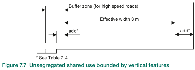
7.35 Note here that 3 metres is the preferred minimum effective width, and this will be the actual width where the route is not bounded by vertical features (see Figure 7.6).
7.36 Figure 7.7 shows an example of unsegregated shared use alongside a typical urban carriageway. In this case, the vertical edge features create the need for additional width – see Table 7.4.
Where sign posts or lamp columns are present, they should be located outside the effective width zone where possible.

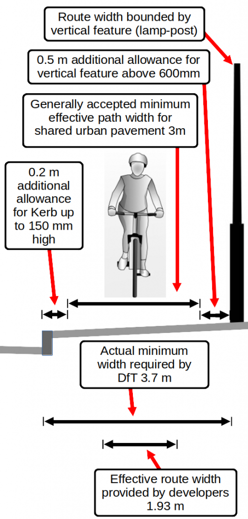
Putting this into the local context of the White House Farm shared cycle-track, to maintain a “effective route width” minimum of three metres, an actual width of 3.7 metres would be required with the designs chosen by the developers (and permitted by the local authorities). The diagram below illustrates the DfT requirements for a shared use cycle track at the time the planning application was granted.
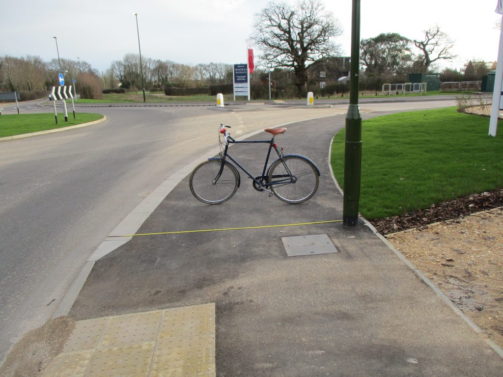
Below is an image taken of a tape measurement taken perpendicular to the kerb on the pavement now labelled as a cycleway entering the White House Farm development.

There is no conceivable reason why the lamppost needed to be set into the cycleway and DfT guidance is that it should be located away from the cycle-track.
There is other street furniture installed on the new spine road restricting the effective width of the cycle track to below 2 metres wide! Further images shown below.
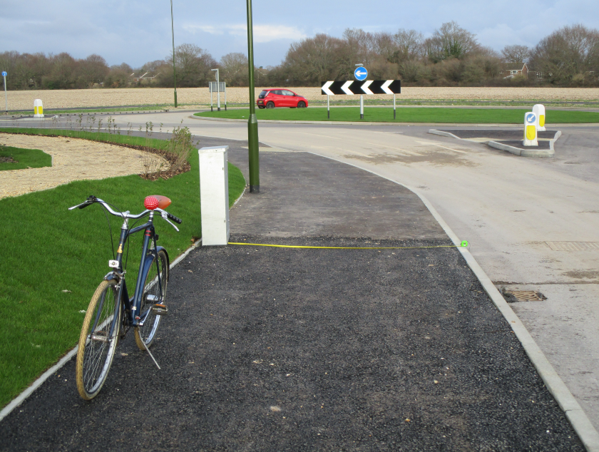
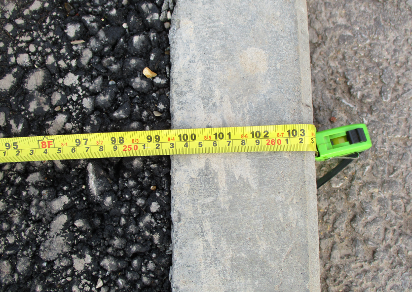
With the cycle track width already below the DfT minimum due to additional width required at vertical kerbs it is difficult to understand the necessity to further limit the width by placing the lamp-post in the cycle track.
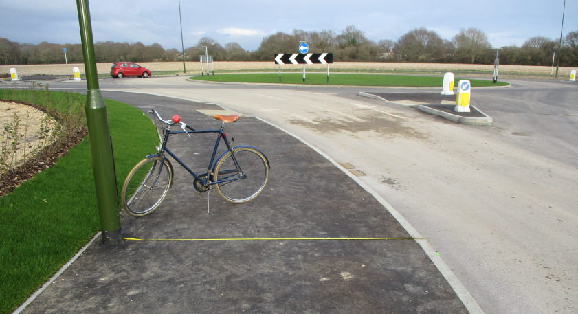
ChiCycle are concerned because previous demands that bus stops and traffic crossing should be planned in have been rejected. We have been told that they do not require any advanced planning! Now that this cycle-track infrastructure has been constructed it is hard to understand how street furniture for signs and bus-stops could be installed without further restricting the width.
ChiCycle will be contacting the local authorities to see if they have any explanation for ignoring transport design principals laid out by the Department of Transport for walking and cycling. With a climate emergency demanding we encourage walking and cycling as an alternative to car dependency, it is essential that our infrastructure at least meets minimum standards that have been in place for 13 years.
We will post details as soon as we receive a response on these matter.
Mark Record
2 thoughts on “Infrastructure specifications in place for 13 Years have been ignored by our Local Planning Authorities and Councillors”
Thank you so much for your work on exposing such pitiful shocking dereliction of duty. This was, after all, a ‘greenfield site’ so there is no excuse.
Determined for much better active travel infrastructure on the Phase 2, especially where the National Cycle Networks Nos. 2 and 88 (and connecting links) will be impacted by the WHF Access Spine Roads.
Thanks for the analysis Mark – This makes for disappointing reading.
I am left wondering (yet again!) what consultation was undertaken to understand how a space needs to be functionally purposeful and safe for anyone with a mobility issue, disability, or those that use adaptive cycles.